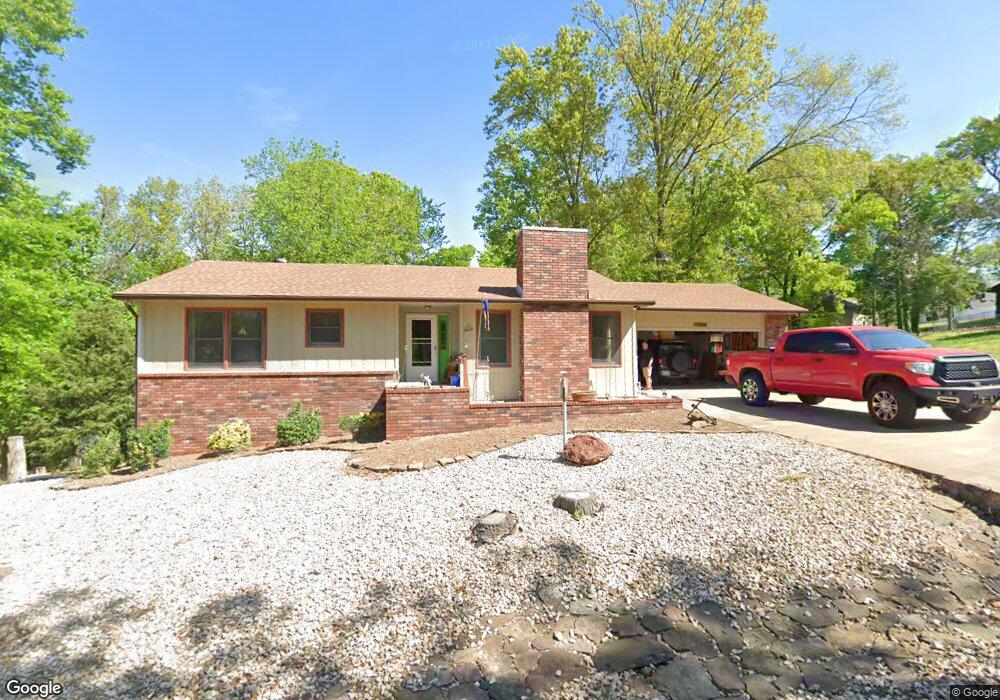
4 Martham Ln Bella Vista, AR 72715
Estimated Value: $250,168 - $302,000
--
Bed
2
Baths
1,200
Sq Ft
$229/Sq Ft
Est. Value
About This Home
This home is located at 4 Martham Ln, Bella Vista, AR 72715 and is currently estimated at $275,292, approximately $229 per square foot. 4 Martham Ln is a home located in Benton County with nearby schools including Thomas Jefferson Elementary School, Lincoln Junior High School, and Old High Middle School.
Ownership History
Date
Name
Owned For
Owner Type
Purchase Details
Closed on
Jan 15, 2016
Sold by
Burr Deborah Jean and Robert E Cummer Revocable Trus
Bought by
Cummer Thomas Robert
Current Estimated Value
Purchase Details
Closed on
Apr 28, 1997
Bought by
Cummer Tr
Purchase Details
Closed on
Apr 25, 1997
Bought by
Cummer Rev Trust
Purchase Details
Closed on
Dec 22, 1996
Bought by
Dod 12-22-1996
Purchase Details
Closed on
Oct 22, 1982
Bought by
Cummer
Create a Home Valuation Report for This Property
The Home Valuation Report is an in-depth analysis detailing your home's value as well as a comparison with similar homes in the area
Home Values in the Area
Average Home Value in this Area
Purchase History
| Date | Buyer | Sale Price | Title Company |
|---|---|---|---|
| Cummer Thomas Robert | -- | Attorney | |
| Cummer Tr | -- | -- | |
| Cummer Rev Trust | -- | -- | |
| Dod 12-22-1996 | -- | -- | |
| Cummer | $8,000 | -- |
Source: Public Records
Tax History Compared to Growth
Tax History
| Year | Tax Paid | Tax Assessment Tax Assessment Total Assessment is a certain percentage of the fair market value that is determined by local assessors to be the total taxable value of land and additions on the property. | Land | Improvement |
|---|---|---|---|---|
| 2025 | $1,266 | $47,389 | $1,600 | $45,789 |
| 2024 | $1,253 | $47,389 | $1,600 | $45,789 |
| 2023 | $1,253 | $30,060 | $800 | $29,260 |
| 2022 | $918 | $30,060 | $800 | $29,260 |
| 2021 | $915 | $30,060 | $800 | $29,260 |
| 2020 | $927 | $20,440 | $600 | $19,840 |
| 2019 | $927 | $20,440 | $600 | $19,840 |
| 2018 | $952 | $20,440 | $600 | $19,840 |
| 2017 | $777 | $20,440 | $600 | $19,840 |
| 2016 | $777 | $20,440 | $600 | $19,840 |
| 2015 | $1,109 | $18,390 | $1,000 | $17,390 |
| 2014 | $1,109 | $18,390 | $1,000 | $17,390 |
Source: Public Records
Map
Nearby Homes
- Lot 26 Block 2 Kensington Dr
- 30 Kensington Dr
- 13 Kensington Dr
- 22 Pembroke Ln
- TBD Dunsford Dr
- Lot 23 of Block 1 Dunsford Dr
- 6 & 8 Gail Ln
- 14 Gretchen Ln
- 55 Portsmouth Dr
- 4 Frensham Ln
- 9 Estes Dr
- 9 Connie Ln
- 7 Joanie Ln
- 6 Connie Ln
- 3 Lance Ln
- 21 Estes Dr
- 18 Worstead Ln
- 0 Portsmouth Dr Unit 1319021
- 5 Matlock Cir
- 19 Brompton Dr
- 2 Martham Ln
- 0 Martham Ln
- Lot 71 Martham Ln
- 18 Martham Ln
- 12 Kensington Dr
- 18 Kensington Dr
- 20 Kensington Dr
- 1 Martham Ln
- 14 Kensington Dr
- 22 Kensington Dr
- 1200 Kensington Dr
- 1231 Kensington Dr
- 11 Martham Ln
- 10 Kensington Dr
- 24 Kensington Dr
- 10 Martham Ln
- 2 Kensington Ln
- 2 Kensington Dr
- 5 Ashfield Ln
- 11 Kensington Dr