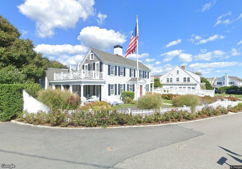
4 Merchants Way Hyannis, MA 2601
Estimated Value: $550,000 - $3,603,756
4
Beds
4
Baths
3,274
Sq Ft
$634/Sq Ft
Est. Value
About This Home
This home is located at 4 Merchants Way, Hyannis, MA 2601 and is currently estimated at $2,076,878, approximately $634 per square foot. 4 Merchants Way is a home located in Barnstable County with nearby schools including Barnstable United Elementary School, West Barnstable Elementary School, and Barnstable Intermediate School.
Ownership History
Date
Name
Owned For
Owner Type
Purchase Details
Closed on
Oct 30, 2015
Sold by
Notrelle Holdings Llc
Bought by
Desai Amit R and Desai Gitika M
Current Estimated Value
Home Financials for this Owner
Home Financials are based on the most recent Mortgage that was taken out on this home.
Original Mortgage
$1,432,125
Outstanding Balance
$1,125,224
Interest Rate
3.92%
Mortgage Type
Purchase Money Mortgage
Estimated Equity
$951,654
Purchase Details
Closed on
Mar 30, 2009
Sold by
Nawn James W
Bought by
Notrelle Holdings Llc
Purchase Details
Closed on
Mar 3, 1998
Sold by
Oneill J Brian and Oneill Miriam P
Bought by
Nawn James W
Home Financials for this Owner
Home Financials are based on the most recent Mortgage that was taken out on this home.
Original Mortgage
$350,000
Interest Rate
6.85%
Mortgage Type
Purchase Money Mortgage
Create a Home Valuation Report for This Property
The Home Valuation Report is an in-depth analysis detailing your home's value as well as a comparison with similar homes in the area
Home Values in the Area
Average Home Value in this Area
Purchase History
| Date | Buyer | Sale Price | Title Company |
|---|---|---|---|
| Desai Amit R | $2,134,500 | -- | |
| Notrelle Holdings Llc | $1,800,000 | -- | |
| Notrelle Holdings Llc | $1,800,000 | -- | |
| Nawn James W | $895,000 | -- | |
| Nawn James W | $895,000 | -- |
Source: Public Records
Mortgage History
| Date | Status | Borrower | Loan Amount |
|---|---|---|---|
| Open | Desai Amit R | $1,432,125 | |
| Closed | Nawn James W | $1,432,125 | |
| Previous Owner | Nawn James W | $350,000 |
Source: Public Records
Tax History Compared to Growth
Tax History
| Year | Tax Paid | Tax Assessment Tax Assessment Total Assessment is a certain percentage of the fair market value that is determined by local assessors to be the total taxable value of land and additions on the property. | Land | Improvement |
|---|---|---|---|---|
| 2025 | $32,223 | $3,476,000 | $2,434,200 | $1,041,800 |
| 2024 | $30,331 | $3,351,500 | $2,434,200 | $917,300 |
| 2023 | $26,163 | $2,733,900 | $1,952,600 | $781,300 |
| 2022 | $26,256 | $2,269,300 | $1,639,200 | $630,100 |
| 2021 | $26,313 | $2,209,300 | $1,639,200 | $570,100 |
| 2020 | $25,068 | $2,033,100 | $1,528,300 | $504,800 |
| 2019 | $25,471 | $2,024,700 | $1,518,700 | $506,000 |
| 2018 | $24,992 | $2,031,900 | $1,598,600 | $433,300 |
| 2017 | $23,970 | $1,999,200 | $1,598,600 | $400,600 |
| 2016 | $22,218 | $1,894,100 | $1,653,800 | $240,300 |
| 2015 | $21,409 | $1,850,400 | $1,560,300 | $290,100 |
Source: Public Records
Map
Nearby Homes
- 0 Phinneys Ln
- 800 Bearses Way Unit 2SB
- 800 Bearses Way Unit 2SF
- 800 Bearses Way Unit 1WD
- 800 Bearses Way Unit 1
- 800 Bearses Way Unit 1NE
- 800 Bearse's Unit 1WD
- 294 Salt Rock Rd
- 210 Attucks Ln
- 230 Attucks Ln
- 240 Braggs Ln
- 43 Statice Ln
- 25 Daybreak Ln
- 15 Square Rigger Ln
- 2 Longview Dr
- 0 Indian Trail
- 370 Compass Cir
- 41 Dromoland Ln
- 7 Delta St
- 78 Brant Way
- 14 Merchants Way
- 28 Merchants Way
- 25 Merchants Way
- 40 Merchants Way
- 20 Merchants Way
- 50 Merchants Way
- 35 Business Ln
- 230 Kidds Hill Rd
- 65 Merchants Way
- 11 Thornton Dr
- 53 Thornton Dr
- 53 Thornton Dr
- 73 Thornton Dr
- 31 Thornton Dr
- 93 Thornton Dr
- 52 Thornton Dr
- 82 Thornton Dr
- 100 Merchants Way
- 84 Thornton Dr
- 80 Thornton Dr