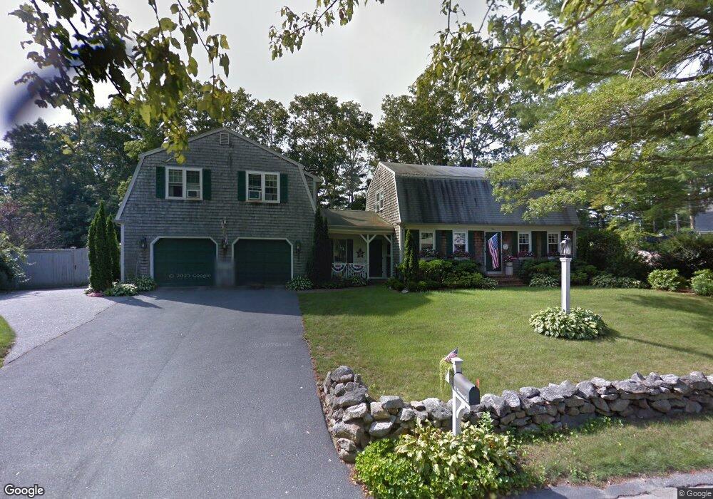
4 Norman St Acushnet, MA 02743
Sherwood Forest NeighborhoodEstimated Value: $628,767 - $768,000
Studio
2
Baths
3,135
Sq Ft
$223/Sq Ft
Est. Value
About This Home
This home is located at 4 Norman St, Acushnet, MA 02743 and is currently estimated at $697,942, approximately $222 per square foot. 4 Norman St is a home located in Bristol County with nearby schools including Acushnet Elementary School, Albert F Ford Middle School, and St Francis Xavier Elementary School.
Ownership History
Date
Name
Owned For
Owner Type
Purchase Details
Closed on
Aug 18, 2023
Sold by
Hamel Francis B and Hamel Marcia A
Bought by
Hamel Francis B and Hamel Marcia A
Current Estimated Value
Purchase Details
Closed on
May 9, 1974
Bought by
Hamel Francis B and Hamel Marcia A
Create a Home Valuation Report for This Property
The Home Valuation Report is an in-depth analysis detailing your home's value as well as a comparison with similar homes in the area
Home Values in the Area
Average Home Value in this Area
Purchase History
| Date | Buyer | Sale Price | Title Company |
|---|---|---|---|
| Hamel Francis B | -- | None Available | |
| Hamel Francis B | -- | -- |
Source: Public Records
Mortgage History
| Date | Status | Borrower | Loan Amount |
|---|---|---|---|
| Previous Owner | Hamel Francis B | $45,000 | |
| Previous Owner | Hamel Francis B | $40,000 |
Source: Public Records
Tax History
| Year | Tax Paid | Tax Assessment Tax Assessment Total Assessment is a certain percentage of the fair market value that is determined by local assessors to be the total taxable value of land and additions on the property. | Land | Improvement |
|---|---|---|---|---|
| 2025 | $62 | $574,800 | $145,000 | $429,800 |
| 2024 | $5,642 | $494,500 | $126,800 | $367,700 |
| 2023 | $5,566 | $463,800 | $115,500 | $348,300 |
| 2022 | $5,150 | $388,100 | $108,700 | $279,400 |
| 2021 | $5,019 | $362,900 | $108,700 | $254,200 |
| 2020 | $5,059 | $362,900 | $108,700 | $254,200 |
| 2019 | $4,966 | $350,200 | $108,700 | $241,500 |
| 2018 | $4,803 | $333,100 | $108,700 | $224,400 |
| 2017 | $4,683 | $324,300 | $108,700 | $215,600 |
| 2016 | $4,446 | $306,000 | $108,700 | $197,300 |
| 2015 | $4,370 | $306,000 | $108,700 | $197,300 |
Source: Public Records
Map
Nearby Homes
- 329 Middle Rd
- 134 Nyes Ln
- 1015 Forbes St
- 40 Foley Dr
- ES Acushnet Ave
- 7 Hamlin St
- 23 Coury Dr
- 1044 Phillips Rd Unit 25
- 1044 Phillips Rd Unit 20
- 2800 Acushnet Ave
- 973 Pembroke St
- 1044 Victoria St Unit B-29
- 1056 Victoria St Unit A-13
- 765 Pine Hill Dr
- 0 Church Dutton & Chaffee Unit 73371719
- 78 Greenbrier Dr
- SS Charbonneau Ln
- 1251 Church St Unit 10
- 1027 Kenmore St
- Lot 3 Beverly St
Your Personal Tour Guide
Ask me questions while you tour the home.