
4 Phillips Rd Nahant, MA 01908
Estimated Value: $910,482 - $1,031,000
Highlights
- Marina
- Golf Course Community
- Deck
- Swampscott High School Rated A-
- Waterfront
- Property is near public transit and schools
About This Home
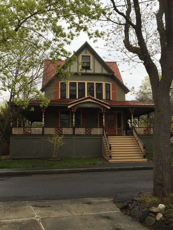
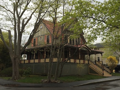
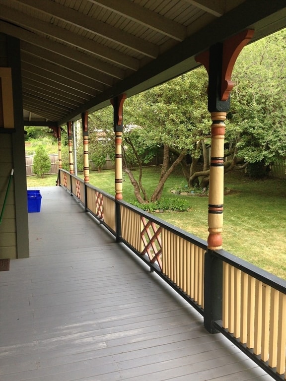
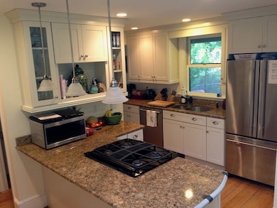
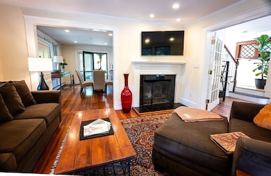
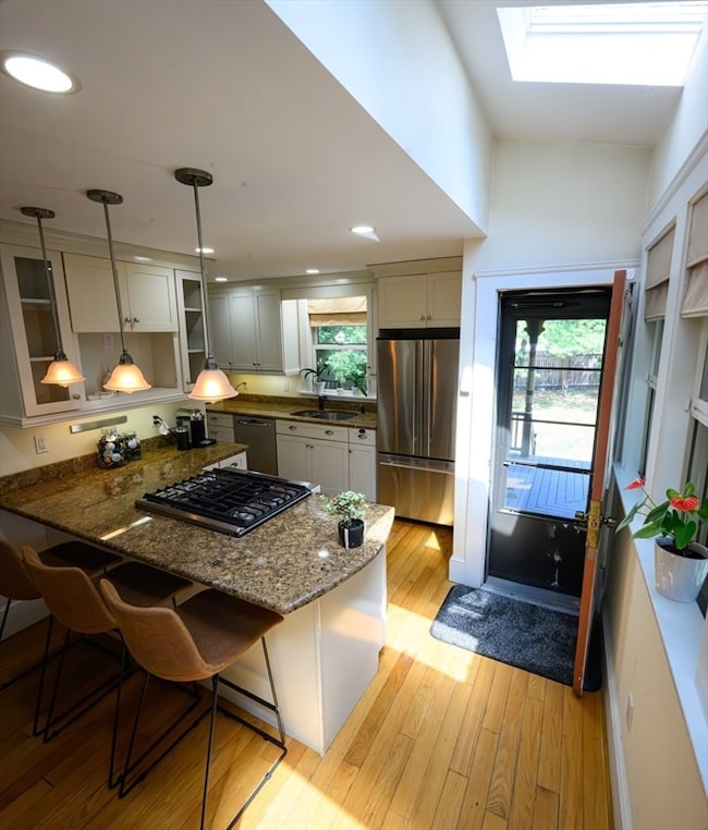
As of December 2025Magnificent architectural OCEAN VIEWS historical home steps to ocean and Nahant Beach with full wrap around porch and sunset views ,,,four levels of living space , a master suite with two walk in closets. Four bedrooms on second floor with built in drawers etc, open floor plan on first floor with modern stainless dishwasher disposal , downdraft gas stove granite counter tops and three skylights , fireplace living room, full dining room,,,,house is super insulated with highly efficient baseboard heating system 12 min to Logan airport 10 minutes,,14 miles to downtown Boston. Walk to bus line
Home Details
Home Type
- Single Family
Year Built
- Built in 1900
Lot Details
- 2,850 Sq Ft Lot
- Waterfront
- Fenced Yard
- Garden
Parking
- 3 Open Parking Spaces
Home Design
- Entry on the 1st floor
Interior Spaces
- 2,000 Sq Ft Home
- 1 Fireplace
- Washer Hookup
- Basement
Kitchen
- Range
- Dishwasher
- Disposal
Bedrooms and Bathrooms
- 4 Bedrooms
Outdoor Features
- Deck
- Porch
Location
- Property is near public transit and schools
Utilities
- No Cooling
- Heating System Uses Natural Gas
Listing and Financial Details
- Security Deposit $4,400
- Property Available on 12/1/25
- Rent includes garden area
- Assessor Parcel Number M:0021A B:0000 L:0116A,2063285
Community Details
Overview
- No Home Owners Association
- Near Conservation Area
Recreation
- Marina
- Golf Course Community
- Jogging Path
Ownership History
Purchase Details
Home Financials for this Owner
Home Financials are based on the most recent Mortgage that was taken out on this home.Purchase Details
Home Financials for this Owner
Home Financials are based on the most recent Mortgage that was taken out on this home.Purchase Details
Home Values in the Area
Average Home Value in this Area
Purchase History
| Date | Buyer | Sale Price | Title Company |
|---|---|---|---|
| Mazareas Peter | -- | -- | |
| Mazareas Peter | -- | -- | |
| Strategic Advmnt Grp I | -- | -- | |
| Strategic Advmnt Grp I | -- | -- | |
| Mazareas Peter | $515,000 | -- | |
| Mazareas Peter | $515,000 | -- |
Mortgage History
| Date | Status | Borrower | Loan Amount |
|---|---|---|---|
| Open | Mazareas Peter | $393,750 | |
| Closed | Mazareas Peter | $393,750 | |
| Previous Owner | Mazareas Peter | $393,750 |
Property History
| Date | Event | Price | List to Sale | Price per Sq Ft |
|---|---|---|---|---|
| 12/09/2025 12/09/25 | Off Market | $4,400 | -- | -- |
| 11/06/2025 11/06/25 | For Rent | $4,400 | -- | -- |
Tax History
| Year | Tax Paid | Tax Assessment Tax Assessment Total Assessment is a certain percentage of the fair market value that is determined by local assessors to be the total taxable value of land and additions on the property. | Land | Improvement |
|---|---|---|---|---|
| 2025 | $8,297 | $906,800 | $522,400 | $384,400 |
| 2024 | $8,042 | $886,700 | $502,300 | $384,400 |
| 2023 | $7,328 | $806,200 | $442,100 | $364,100 |
| 2022 | $6,951 | $710,000 | $381,800 | $328,200 |
| 2021 | $6,832 | $650,000 | $341,600 | $308,400 |
| 2020 | $6,658 | $606,900 | $341,600 | $265,300 |
| 2019 | $5,889 | $539,800 | $301,400 | $238,400 |
| 2018 | $5,478 | $534,400 | $301,400 | $233,000 |
| 2017 | $5,595 | $534,400 | $301,400 | $233,000 |
| 2016 | $5,422 | $515,400 | $291,400 | $224,000 |
| 2015 | $5,024 | $460,100 | $236,100 | $224,000 |
| 2014 | $5,075 | $460,100 | $236,100 | $224,000 |
Map
Source: MLS Property Information Network (MLS PIN)
MLS Number: 73452024
APN: NAHA-000021A-000000-000116A
Disclaimer: Certain information contained herein is derived from information provided by parties other than Homes.com. All information provided is deemed reliable, but is not guaranteed to be accurate and should be independently verified.
![]() The property listing data and information, or the Images, set forth herein were provided to MLS Property Information Network, Inc. from third party sources, including sellers, lessors and public records, and were compiled by MLS Property Information Network, Inc. The property listing data and information, and the Images, are for the personal, non-commercial use of consumers having a good faith interest in purchasing or leasing listed properties of the type displayed to them and may not be used for any purpose other than to identify prospective properties which such consumers may have a good faith interest in purchasing or leasing. MLS Property Information Network, Inc. and its subscribers disclaim any and all representations and warranties as to the accuracy of the property listing data and information, or as to the accuracy of any of the Images, set forth herein.
The property listing data and information, or the Images, set forth herein were provided to MLS Property Information Network, Inc. from third party sources, including sellers, lessors and public records, and were compiled by MLS Property Information Network, Inc. The property listing data and information, and the Images, are for the personal, non-commercial use of consumers having a good faith interest in purchasing or leasing listed properties of the type displayed to them and may not be used for any purpose other than to identify prospective properties which such consumers may have a good faith interest in purchasing or leasing. MLS Property Information Network, Inc. and its subscribers disclaim any and all representations and warranties as to the accuracy of the property listing data and information, or as to the accuracy of any of the Images, set forth herein.
- 30 Sherman Ave
- 1 Goddard Dr
- 183 Bass Point Rd
- 9 Little Nahant Rd
- 66 Ocean St
- 162 Willow Rd Unit 11
- 51 Cliff St
- 1 Carey Cir Unit 409
- 191 N Shore Rd
- 123 Mills Ave
- 11 Archer Ave
- 31 Mills Ave
- 510 Revere Beach Blvd Unit 1205
- 510 Revere Beach Blvd Unit 905
- 505 Revere Beach Blvd Unit 303
- 98 Lynnway
- 12 Chancery Ct Unit 404
- 474 Revere Beach Blvd Unit 501
- 474 Revere Beach Blvd Unit 903
- 474 Revere Beach Blvd Unit 302
Ask me questions while you tour the home.