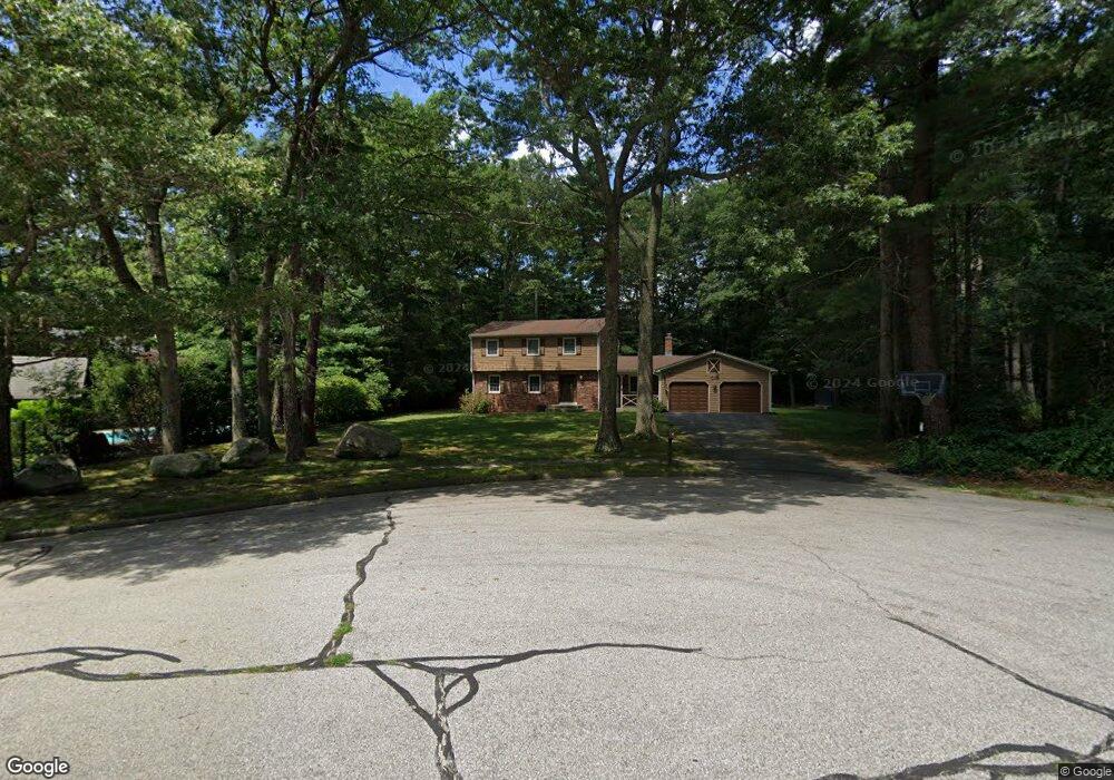
4 Red Cedar Dr Coventry, RI 02816
Estimated Value: $620,908 - $642,000
4
Beds
3
Baths
2,262
Sq Ft
$278/Sq Ft
Est. Value
About This Home
This home is located at 4 Red Cedar Dr, Coventry, RI 02816 and is currently estimated at $629,727, approximately $278 per square foot. 4 Red Cedar Dr is a home located in Kent County with nearby schools including Alan Shawn Feinstein Ms Of Cov, Coventry High School, and Father John V. Doyle School.
Ownership History
Date
Name
Owned For
Owner Type
Purchase Details
Closed on
Jun 28, 2002
Sold by
Lebrun Donald A and Lebrun Lori J
Bought by
Shylanski Scott W and Shylanski Michelle
Current Estimated Value
Home Financials for this Owner
Home Financials are based on the most recent Mortgage that was taken out on this home.
Original Mortgage
$228,000
Interest Rate
6.92%
Purchase Details
Closed on
Aug 16, 1995
Sold by
Zelenak John S and Zelenak Adrienne
Bought by
Lebrun Donald A and Lebrun Lori
Create a Home Valuation Report for This Property
The Home Valuation Report is an in-depth analysis detailing your home's value as well as a comparison with similar homes in the area
Home Values in the Area
Average Home Value in this Area
Purchase History
| Date | Buyer | Sale Price | Title Company |
|---|---|---|---|
| Shylanski Scott W | $285,000 | -- | |
| Lebrun Donald A | $180,000 | -- |
Source: Public Records
Mortgage History
| Date | Status | Borrower | Loan Amount |
|---|---|---|---|
| Open | Lebrun Donald A | $194,400 | |
| Closed | Lebrun Donald A | $227,300 | |
| Closed | Lebrun Donald A | $228,000 | |
| Previous Owner | Lebrun Donald A | $165,300 |
Source: Public Records
Tax History Compared to Growth
Tax History
| Year | Tax Paid | Tax Assessment Tax Assessment Total Assessment is a certain percentage of the fair market value that is determined by local assessors to be the total taxable value of land and additions on the property. | Land | Improvement |
|---|---|---|---|---|
| 2024 | $7,139 | $450,700 | $171,600 | $279,100 |
| 2023 | $6,909 | $450,700 | $171,600 | $279,100 |
| 2022 | $6,253 | $319,500 | $161,800 | $157,700 |
| 2021 | $6,198 | $319,500 | $161,800 | $157,700 |
| 2020 | $7,106 | $319,500 | $161,800 | $157,700 |
| 2019 | $5,943 | $267,200 | $136,100 | $131,100 |
| 2018 | $5,774 | $267,200 | $136,100 | $131,100 |
| 2017 | $5,606 | $267,200 | $136,100 | $131,100 |
| 2016 | $5,922 | $276,600 | $116,900 | $159,700 |
| 2015 | $5,762 | $276,600 | $116,900 | $159,700 |
| 2014 | $5,641 | $276,600 | $116,900 | $159,700 |
| 2013 | $5,484 | $293,900 | $127,900 | $166,000 |
Source: Public Records
Map
Nearby Homes
- 3 Crocus Ct
- 2 Huckleberry Rd
- 13 Valiant Dr
- 4 Liena Rose Way
- 33 Sunset Lake Cir
- 28 Airport Rd
- 51 Sunset Lake Cir
- 81 Sunset Lake Cir
- 83 Sunset Lake Cir
- 18 Magnolia Ln
- 9 Torch Ln
- 8 King Philip Rd
- 21 Lear Dr
- 11 Torch Ln
- 9 Giovanni Rose Ct
- 17 Wood Cove Dr
- 35 Liena Rose Way
- 89 Wisteria Dr
- 50 Isle of Capri Rd
- 207 Shady Valley Rd
- 129 Wood Cove Dr
- 127 Wood Cove Dr
- 5 Red Cedar Dr
- 46 Club House Rd
- 131 Wood Cove Dr
- 125 Wood Cove Dr
- 133 Wood Cove Dr
- 126 Wood Cove Dr
- 128 Wood Cove Dr
- 123 Wood Cove Dr
- 124 Wood Cove Dr
- 43 Club House Rd
- 132 Wood Cove Dr
- 41 Club House Rd
- 130 Wood Cove Dr
- 45 Club House Rd
- 39 Club House Rd
- 47 Club House Rd
- 121 Wood Cove Dr
- 122 Wood Cove Dr