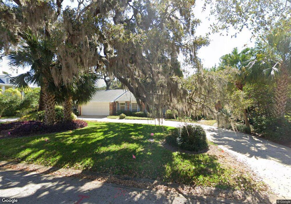
4 Riverside Cir Ormond Beach, FL 32176
Estimated Value: $643,000 - $819,958
3
Beds
3
Baths
2,350
Sq Ft
$320/Sq Ft
Est. Value
About This Home
This home is located at 4 Riverside Cir, Ormond Beach, FL 32176 and is currently estimated at $752,653, approximately $320 per square foot. 4 Riverside Cir is a home located in Volusia County with nearby schools including Ormond Beach Middle School, Seabreeze High School, and St Brendan Catholic School.
Ownership History
Date
Name
Owned For
Owner Type
Purchase Details
Closed on
Jul 8, 2020
Sold by
Foy Douglas I and Foy Leonie
Bought by
Foy Douglas I and The Douglas I Foy Trusttr
Current Estimated Value
Purchase Details
Closed on
Jan 18, 2010
Sold by
Foy Andrew N and Foy Denise B
Bought by
Foy Douglas I and Foy Leonie
Purchase Details
Closed on
Dec 15, 2009
Sold by
Nelson Lynn W and Foy Lynn
Bought by
Foy Douglas I and Foy Leonie
Purchase Details
Closed on
Dec 11, 2008
Sold by
Foy Douglas I and Foy Andrew N
Bought by
Foy Douglas I and Foy Andrew N
Purchase Details
Closed on
Nov 15, 1987
Bought by
Foy Douglas I and Foy Leonie
Purchase Details
Closed on
Oct 15, 1987
Bought by
Foy Douglas I and Foy Leonie
Purchase Details
Closed on
Jun 15, 1984
Bought by
Foy Douglas I and Foy Leonie
Purchase Details
Closed on
Jun 15, 1980
Bought by
Foy Douglas I and Foy Leonie
Purchase Details
Closed on
Aug 15, 1976
Bought by
Foy Douglas I and Foy Leonie
Create a Home Valuation Report for This Property
The Home Valuation Report is an in-depth analysis detailing your home's value as well as a comparison with similar homes in the area
Home Values in the Area
Average Home Value in this Area
Purchase History
| Date | Buyer | Sale Price | Title Company |
|---|---|---|---|
| Foy Douglas I | -- | Attorney | |
| Foy Douglas I | $100,000 | Attorney | |
| Foy Douglas I | $60,000 | Attorney | |
| Foy Douglas I | -- | Attorney | |
| Foy Douglas I | $175,000 | -- | |
| Foy Douglas I | $100 | -- | |
| Foy Douglas I | $135,000 | -- | |
| Foy Douglas I | $129,000 | -- | |
| Foy Douglas I | $80,300 | -- |
Source: Public Records
Tax History
| Year | Tax Paid | Tax Assessment Tax Assessment Total Assessment is a certain percentage of the fair market value that is determined by local assessors to be the total taxable value of land and additions on the property. | Land | Improvement |
|---|---|---|---|---|
| 2026 | $10,636 | $717,295 | $416,416 | $300,879 |
| 2025 | $10,636 | $717,890 | $416,416 | $301,474 |
| 2024 | $9,440 | $722,831 | $416,416 | $306,415 |
| 2023 | $9,440 | $714,732 | $416,416 | $298,316 |
| 2022 | $8,215 | $575,617 | $320,320 | $255,297 |
| 2021 | $7,424 | $421,854 | $234,740 | $187,114 |
| 2020 | $7,846 | $445,691 | $234,740 | $210,951 |
| 2019 | $7,264 | $409,193 | $193,600 | $215,593 |
| 2018 | $7,221 | $408,348 | $193,600 | $214,748 |
| 2017 | $7,015 | $394,629 | $194,000 | $200,629 |
| 2016 | $6,668 | $365,491 | $0 | $0 |
| 2015 | -- | $355,149 | $0 | $0 |
| 2014 | -- | $301,824 | $0 | $0 |
Source: Public Records
Map
Nearby Homes
- 39 Willis Dr
- 65 Seton Trail Unit 8
- 156 Bosarvey Dr
- 123 Arlington Way
- 65 Coquina Dr
- 1 John Anderson Dr Unit 205
- 1 John Anderson Dr Unit 604
- 1 John Anderson Dr Unit 303
- 1 John Anderson Dr Unit 3010
- 1 John Anderson Dr Unit 4120
- 1 John Anderson Dr Unit 301
- 1 John Anderson Dr Unit 412
- 111 S Atlantic Ave Unit 702
- 111 S Atlantic Ave Unit 1104
- 2 Cypress Cir
- 89 S Atlantic Ave Unit 401
- 89 S Atlantic Ave Unit 204
- 89 S Atlantic Ave Unit 404
- 89 S Atlantic Ave Unit 1006
- 89 S Atlantic Ave Unit 1004
- 6 Riverside Cir
- 216 S Halifax Dr
- 213 Riverside Dr
- 8 Riverside Cir
- 3 Riverside Cir
- 195 Riverside Dr
- 5 Riverside Cir
- 235 Riverside Dr
- 171 Riverside Dr
- 202 Riverside Dr
- 192 S Halifax Dr
- 192 Riverside Dr
- 222 S Halifax Dr
- 222 Riverside Dr
- 186 S Halifax Dr
- 165 Riverside Dr
- 182 Riverside Dr
- 249 Riverside Dr
- 167 Riverside Dr
- 228 S Halifax Dr
Your Personal Tour Guide
Ask me questions while you tour the home.