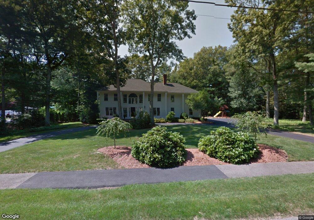
4 Robin Rd Norfolk, MA 02056
Estimated Value: $916,744 - $1,698,000
4
Beds
3
Baths
3,200
Sq Ft
$361/Sq Ft
Est. Value
About This Home
This home is located at 4 Robin Rd, Norfolk, MA 02056 and is currently estimated at $1,156,436, approximately $361 per square foot. 4 Robin Rd is a home located in Norfolk County with nearby schools including H. Olive Day School, Freeman-Kennedy School, and Woodside Montessori Academy.
Ownership History
Date
Name
Owned For
Owner Type
Purchase Details
Closed on
Dec 31, 1996
Sold by
Traynor Jean B and Traynor Lawrence E
Bought by
Mccarthy Michael G and Mccarthy Lorraine M
Current Estimated Value
Home Financials for this Owner
Home Financials are based on the most recent Mortgage that was taken out on this home.
Original Mortgage
$130,000
Outstanding Balance
$13,862
Interest Rate
7.55%
Mortgage Type
Purchase Money Mortgage
Estimated Equity
$1,142,574
Purchase Details
Closed on
Jan 28, 1988
Sold by
W & R Realty Corp
Bought by
Traynor Lawrence E
Home Financials for this Owner
Home Financials are based on the most recent Mortgage that was taken out on this home.
Original Mortgage
$285,000
Interest Rate
10.65%
Mortgage Type
Purchase Money Mortgage
Create a Home Valuation Report for This Property
The Home Valuation Report is an in-depth analysis detailing your home's value as well as a comparison with similar homes in the area
Home Values in the Area
Average Home Value in this Area
Purchase History
| Date | Buyer | Sale Price | Title Company |
|---|---|---|---|
| Mccarthy Michael G | $360,000 | -- | |
| Mccarthy Michael G | $360,000 | -- | |
| Traynor Lawrence E | $400,000 | -- |
Source: Public Records
Mortgage History
| Date | Status | Borrower | Loan Amount |
|---|---|---|---|
| Open | Mccarthy Michael G | $130,000 | |
| Closed | Traynor Lawrence E | $130,000 | |
| Previous Owner | Traynor Lawrence E | $341,000 | |
| Previous Owner | Traynor Lawrence E | $285,000 |
Source: Public Records
Tax History
| Year | Tax Paid | Tax Assessment Tax Assessment Total Assessment is a certain percentage of the fair market value that is determined by local assessors to be the total taxable value of land and additions on the property. | Land | Improvement |
|---|---|---|---|---|
| 2025 | $12,717 | $796,300 | $191,400 | $604,900 |
| 2024 | $12,585 | $808,300 | $193,100 | $615,200 |
| 2023 | $12,047 | $734,100 | $193,100 | $541,000 |
| 2022 | $11,339 | $623,000 | $181,300 | $441,700 |
| 2021 | $12,474 | $693,400 | $197,100 | $496,300 |
| 2020 | $12,416 | $666,100 | $179,300 | $486,800 |
| 2019 | $11,918 | $651,600 | $179,300 | $472,300 |
| 2018 | $11,321 | $608,000 | $179,300 | $428,700 |
| 2017 | $11,176 | $613,400 | $179,300 | $434,100 |
| 2016 | $11,278 | $623,800 | $202,800 | $421,000 |
| 2015 | $10,932 | $619,000 | $192,700 | $426,300 |
| 2014 | $10,526 | $603,900 | $192,700 | $411,200 |
Source: Public Records
Map
Nearby Homes
- 23 Fredrickson Rd
- 7 Keeney Pond Rd
- 8 Ridgefield Rd
- 16 Keeney Pond Rd
- 0 Toils End Rd
- 45 Joshua Rd
- 246 Forest Grove Ave
- 45 Meetinghouse Rd Unit 45
- 292 Main St
- 0 W Birch Rd
- 19 Waites Crossing
- 13 Waites Crossing
- 3 Elliot Mills Unit 2
- 6 Elliot Mills Unit 31
- 50 Reed Fulton Ave Unit Lot 61
- 14 Waites Crossing
- 9 Elliot Mills Unit 5
- 8 Elliot Mills Unit 30
- 5 Elliot Mills Unit 3
- 7 Elliot Mills Unit 4
Your Personal Tour Guide
Ask me questions while you tour the home.