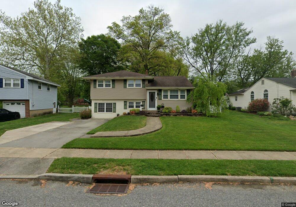
4 Rosetree Ln West Deptford, NJ 08096
West Deptford Township NeighborhoodEstimated Value: $385,338 - $437,000
4
Beds
2
Baths
1,894
Sq Ft
$221/Sq Ft
Est. Value
About This Home
This home is located at 4 Rosetree Ln, West Deptford, NJ 08096 and is currently estimated at $418,335, approximately $220 per square foot. 4 Rosetree Ln is a home located in Gloucester County with nearby schools including Green-Fields Elementary School, Oakview Elementary School, and Red Bank Elementary School.
Ownership History
Date
Name
Owned For
Owner Type
Purchase Details
Closed on
Sep 11, 2019
Sold by
Nicely Michael J and Nicely Melissa E
Bought by
Nicely Michael J and Nicely Melissa E
Current Estimated Value
Purchase Details
Closed on
Oct 23, 2009
Sold by
Mackey Craig and Mackey Jenna
Bought by
Nicely Michael J and Fean Melissa E
Home Financials for this Owner
Home Financials are based on the most recent Mortgage that was taken out on this home.
Original Mortgage
$201,600
Outstanding Balance
$131,507
Interest Rate
5.06%
Mortgage Type
New Conventional
Estimated Equity
$286,828
Purchase Details
Closed on
Dec 30, 2002
Sold by
Smith Donald A and Smith Dawn E
Bought by
Mackey Craig and Long Jenna C
Home Financials for this Owner
Home Financials are based on the most recent Mortgage that was taken out on this home.
Original Mortgage
$156,750
Interest Rate
6.18%
Create a Home Valuation Report for This Property
The Home Valuation Report is an in-depth analysis detailing your home's value as well as a comparison with similar homes in the area
Home Values in the Area
Average Home Value in this Area
Purchase History
| Date | Buyer | Sale Price | Title Company |
|---|---|---|---|
| Nicely Michael J | -- | None Available | |
| Nicely Michael J | $235,000 | Foundation Title Llc | |
| Mackey Craig | $165,000 | Group 21 |
Source: Public Records
Mortgage History
| Date | Status | Borrower | Loan Amount |
|---|---|---|---|
| Open | Nicely Michael J | $201,600 | |
| Previous Owner | Mackey Craig | $156,750 |
Source: Public Records
Tax History Compared to Growth
Tax History
| Year | Tax Paid | Tax Assessment Tax Assessment Total Assessment is a certain percentage of the fair market value that is determined by local assessors to be the total taxable value of land and additions on the property. | Land | Improvement |
|---|---|---|---|---|
| 2025 | $6,719 | $192,400 | $60,600 | $131,800 |
| 2024 | $6,632 | $192,400 | $60,600 | $131,800 |
| 2023 | $6,632 | $192,400 | $60,600 | $131,800 |
| 2022 | $6,601 | $192,400 | $60,600 | $131,800 |
| 2021 | $6,578 | $192,400 | $60,600 | $131,800 |
| 2020 | $6,563 | $192,400 | $60,600 | $131,800 |
| 2019 | $6,380 | $192,400 | $60,600 | $131,800 |
| 2018 | $6,207 | $192,400 | $60,600 | $131,800 |
| 2017 | $6,063 | $192,400 | $60,600 | $131,800 |
| 2016 | $5,893 | $192,400 | $60,600 | $131,800 |
| 2015 | $5,614 | $192,400 | $60,600 | $131,800 |
| 2014 | $5,335 | $192,400 | $60,600 | $131,800 |
Source: Public Records
Map
Nearby Homes
- 10 Meadow Ln
- 15 Ash Ave
- 51 Holly Dr
- 8 Clark Dr
- 6 Cypress Cir
- 417 Auburn St
- 124 Linden Ave
- 90 Ginger Dr
- 136 Vanderbilt Ave
- 0 Greenwood & Shivers Ave
- 629 Vassar Rd
- 14 Aviary Rd
- 418 Westminster Rd
- 94 Aviary Rd
- 807 Saint Regis Ct
- 827 Saint Regis Ct
- 751 Garrison Ct
- 411 Durham Ct Unit 411
- 213 Barclay Ct
- 463 Durham Ct