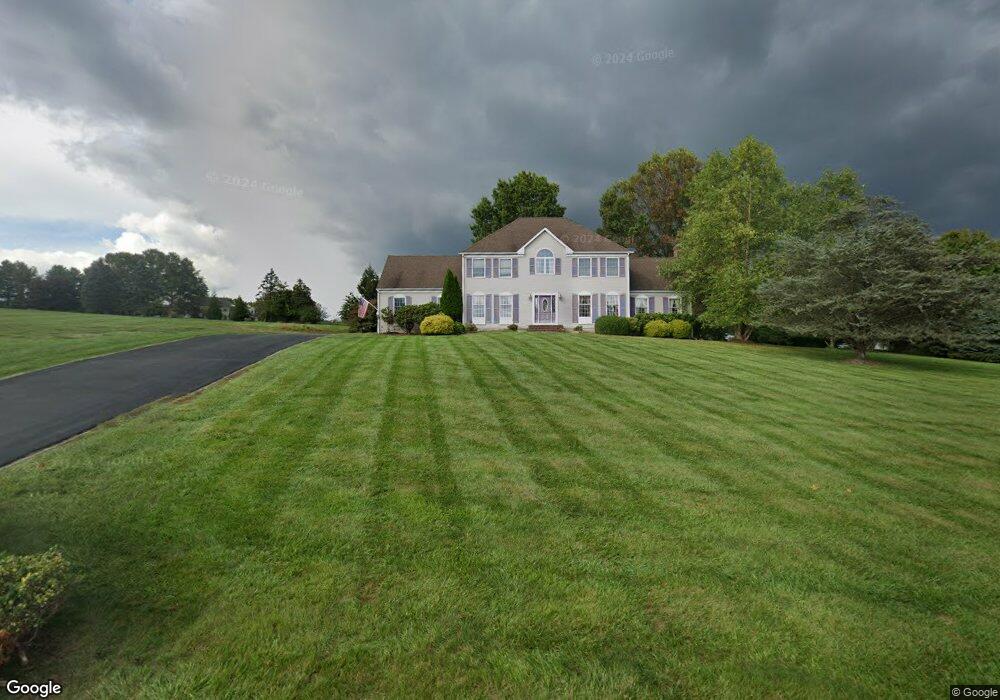
4 Stonebridge Rd Hampton, NJ 08827
Estimated Value: $855,884 - $887,000
Studio
--
Bath
3,488
Sq Ft
$249/Sq Ft
Est. Value
About This Home
This home is located at 4 Stonebridge Rd, Hampton, NJ 08827 and is currently estimated at $869,971, approximately $249 per square foot. 4 Stonebridge Rd is a home located in Hunterdon County with nearby schools including Union Township Elementary School, Union Township Middle School, and North Hunterdon High School.
Ownership History
Date
Name
Owned For
Owner Type
Purchase Details
Closed on
Dec 28, 2004
Sold by
Wang Hwai H and Wang Amy L
Bought by
Ignacz Michael and Ignacz Donna
Current Estimated Value
Home Financials for this Owner
Home Financials are based on the most recent Mortgage that was taken out on this home.
Original Mortgage
$280,000
Outstanding Balance
$141,181
Interest Rate
5.73%
Mortgage Type
Fannie Mae Freddie Mac
Estimated Equity
$728,790
Purchase Details
Closed on
Apr 6, 1992
Sold by
Peterson Louis G and Peterson Josephine
Bought by
Wang Hwai H and Wang Amy L
Create a Home Valuation Report for This Property
The Home Valuation Report is an in-depth analysis detailing your home's value as well as a comparison with similar homes in the area
Home Values in the Area
Average Home Value in this Area
Purchase History
| Date | Buyer | Sale Price | Title Company |
|---|---|---|---|
| Ignacz Michael | $572,500 | -- | |
| Wang Hwai H | $314,000 | -- |
Source: Public Records
Mortgage History
| Date | Status | Borrower | Loan Amount |
|---|---|---|---|
| Open | Ignacz Michael | $280,000 |
Source: Public Records
Tax History
| Year | Tax Paid | Tax Assessment Tax Assessment Total Assessment is a certain percentage of the fair market value that is determined by local assessors to be the total taxable value of land and additions on the property. | Land | Improvement |
|---|---|---|---|---|
| 2025 | $15,859 | $748,400 | $217,800 | $530,600 |
| 2024 | $15,948 | $748,400 | $217,800 | $530,600 |
Source: Public Records
Map
Nearby Homes
- 759 Mechlin Corner Rd
- 22 Oakwood Blvd
- 0 Baptist Church Rd
- 16 Glacier Way
- 60 Perryville Rd
- 217 van Syckels Rd
- 69 Baptist Church Rd
- 584 County Road 614
- 22 Sam Bonnell Dr Unit C0204
- 571 Route 614
- 4 The Crescent
- 93 Overlook Dr Unit 195E
- 509 County Road 579
- 12 N Slope
- 20 Northwood Dr
- 94 N Slope
- 484 Route614
- 64 Hogback Rd
- 201 Sidney Rd
- 210 Sidney Rd
- 6 Stonebridge Rd
- 11 Wolfs Farm Rd
- 3 Stonebridge Rd
- 15 Wolfs Farm Rd
- 5 Stonebridge Rd
- 5 Wolfs Farm Rd
- 19 Wolfs Farm Rd
- 7 Stonebridge Rd
- 8 Stonebridge Rd
- 14 Wolfs Farm Rd
- 12 Wolfs Farm Rd
- 16 Wolfs Farm Rd
- 10 Wolfs Farm Rd
- 9 Stonebridge Rd
- 8 Wolfs Farm Rd
- 18 Wolfs Farm Rd
- 3 Wolfs Farm Rd
- 21 Wolfs Farm Rd
- 209 Main St
- 22 Stonebridge Rd
Your Personal Tour Guide
Ask me questions while you tour the home.