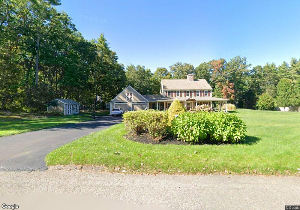
4 Trout Brook Way Shirley, MA 01464
Estimated Value: $726,772 - $862,000
3
Beds
3
Baths
2,772
Sq Ft
$280/Sq Ft
Est. Value
About This Home
This home is located at 4 Trout Brook Way, Shirley, MA 01464 and is currently estimated at $777,193, approximately $280 per square foot. 4 Trout Brook Way is a home located in Middlesex County with nearby schools including Page Hilltop School, Lura A. White Elementary School, and Ayer Shirley Regional Middle School.
Ownership History
Date
Name
Owned For
Owner Type
Purchase Details
Closed on
Jul 30, 2007
Sold by
Hart Robert A and Hart Suzanne L
Bought by
Slocumb Michael S and Slocumb Tracy A
Current Estimated Value
Create a Home Valuation Report for This Property
The Home Valuation Report is an in-depth analysis detailing your home's value as well as a comparison with similar homes in the area
Home Values in the Area
Average Home Value in this Area
Purchase History
| Date | Buyer | Sale Price | Title Company |
|---|---|---|---|
| Slocumb Michael S | $415,000 | -- |
Source: Public Records
Tax History Compared to Growth
Tax History
| Year | Tax Paid | Tax Assessment Tax Assessment Total Assessment is a certain percentage of the fair market value that is determined by local assessors to be the total taxable value of land and additions on the property. | Land | Improvement |
|---|---|---|---|---|
| 2025 | $80 | $618,300 | $140,100 | $478,200 |
| 2024 | $7,909 | $582,800 | $128,100 | $454,700 |
| 2023 | $7,534 | $531,300 | $128,100 | $403,200 |
| 2022 | $7,294 | $471,200 | $124,100 | $347,100 |
| 2021 | $7,174 | $434,000 | $112,100 | $321,900 |
| 2020 | $6,620 | $410,900 | $112,100 | $298,800 |
| 2019 | $6,496 | $404,000 | $112,100 | $291,900 |
| 2018 | $6,465 | $393,700 | $107,300 | $286,400 |
| 2017 | $6,362 | $385,100 | $104,100 | $281,000 |
| 2016 | $6,132 | $371,400 | $104,100 | $267,300 |
| 2015 | $6,306 | $364,300 | $102,500 | $261,800 |
Source: Public Records
Map
Nearby Homes
- 111 Squannacook Rd
- Lot 10 Christian Cir
- 354 Townsend Rd
- 346 Townsend Rd
- 59 Squannacook Rd
- 7a Lilac Cir Unit B
- 49 Magnolia Ln Unit 49
- 21 Magnolia Ln
- 18 Crosswinds Dr
- 37 Pepperell Rd
- 22 Townsend Rd
- 22 Lakin St
- 55 W Main St
- 64 Maplewood Dr
- 65 W Main St
- 43 Longley Rd
- 10 Lakin St
- 1790 Massachusetts Ave Unit 25
- 1790 Mass Ave Unit 3
- 1790 Massachusetts Ave Unit 22
- 6 Trout Brook Way
- 2 Trout Brook Way
- 3 Trout Brook Way
- 5 Trout Brook Way
- 1 Trout Brook Way
- Lot A Hazen Rd
- L-4 Groton Rd
- LOT 1 Squannacook Rd
- Lot 14 Derby Dr
- LOT C Phoenix Pond Cir
- LOT A Shaker Rd
- lot 46 Myles
- LOT 21 Kelsey Ln
- LOT 1 Rodman Ave
- LOT 2 Rodman Ave
- LOT A Little Turnpike Rd
- LOT 2 Clark Rd
- LOT8 Peabody Rd
- LOT7 Peabody Rd
- LOT 3A Clark Rd