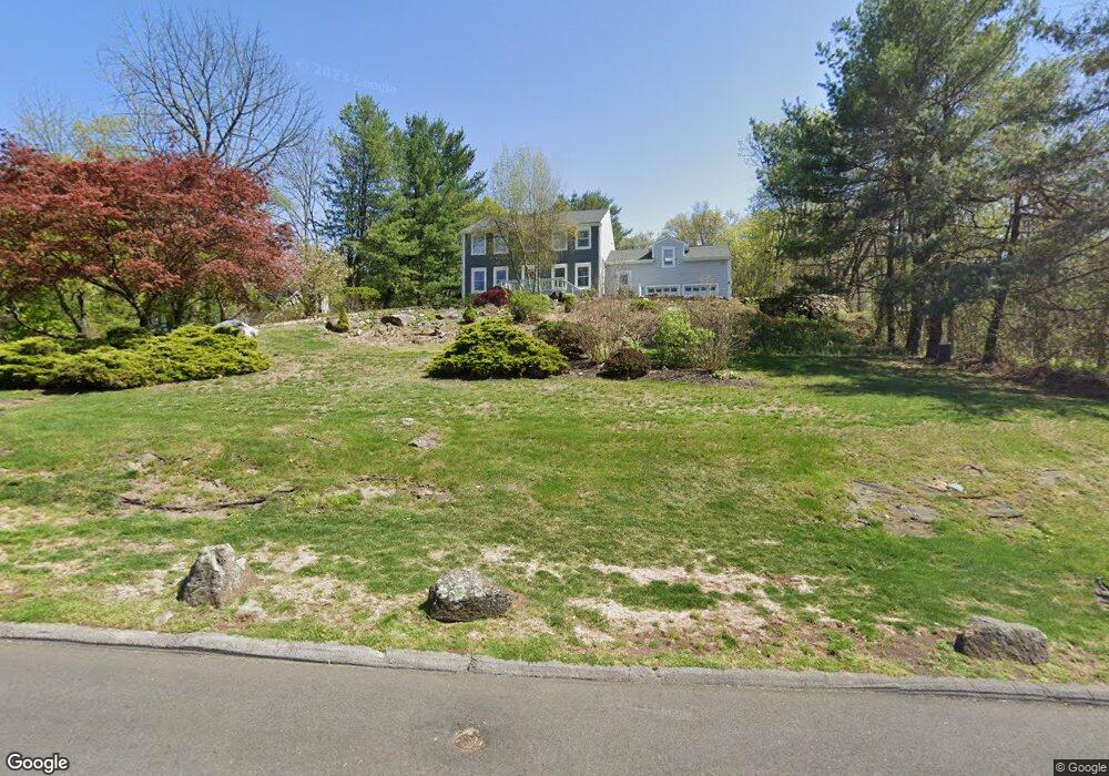
4 White Lion Dr Montrose, NY 10548
Estimated Value: $875,134 - $1,100,000
--
Bed
--
Bath
--
Sq Ft
0.69
Acres
About This Home
This home is located at 4 White Lion Dr, Montrose, NY 10548 and is currently estimated at $995,784. 4 White Lion Dr is a home located in Westchester County with nearby schools including Frank G. Lindsey Elementary School, Blue Mountain Middle School, and Hendrick Hudson High School.
Ownership History
Date
Name
Owned For
Owner Type
Purchase Details
Closed on
Aug 12, 2003
Sold by
Healy Pamela and Conry Pamela
Bought by
Burke Timothy E and Burke Emily M
Current Estimated Value
Purchase Details
Closed on
Oct 11, 1999
Sold by
Leone Maury A and Leone Donna M
Bought by
Conry Pamela
Home Financials for this Owner
Home Financials are based on the most recent Mortgage that was taken out on this home.
Original Mortgage
$331,600
Interest Rate
7.68%
Create a Home Valuation Report for This Property
The Home Valuation Report is an in-depth analysis detailing your home's value as well as a comparison with similar homes in the area
Home Values in the Area
Average Home Value in this Area
Purchase History
| Date | Buyer | Sale Price | Title Company |
|---|---|---|---|
| Burke Timothy E | $550,000 | -- | |
| Conry Pamela | $414,500 | -- |
Source: Public Records
Mortgage History
| Date | Status | Borrower | Loan Amount |
|---|---|---|---|
| Previous Owner | Conry Pamela | $331,600 |
Source: Public Records
Tax History Compared to Growth
Tax History
| Year | Tax Paid | Tax Assessment Tax Assessment Total Assessment is a certain percentage of the fair market value that is determined by local assessors to be the total taxable value of land and additions on the property. | Land | Improvement |
|---|---|---|---|---|
| 2024 | $17,337 | $9,835 | $700 | $9,135 |
| 2023 | $16,724 | $9,835 | $700 | $9,135 |
| 2022 | $16,694 | $9,835 | $700 | $9,135 |
| 2021 | $16,372 | $9,835 | $700 | $9,135 |
| 2020 | $15,981 | $9,835 | $700 | $9,135 |
| 2019 | $15,338 | $9,835 | $700 | $9,135 |
| 2018 | $13,797 | $9,835 | $700 | $9,135 |
| 2017 | $8,577 | $9,835 | $700 | $9,135 |
| 2016 | $14,957 | $9,835 | $700 | $9,135 |
| 2015 | -- | $9,835 | $700 | $9,135 |
| 2014 | -- | $9,835 | $700 | $9,135 |
| 2013 | -- | $9,835 | $700 | $9,135 |
Source: Public Records
Map
Nearby Homes
- 137 Lindsey Ave
- 219 Rockledge Ave
- 216 Rockledge Ave
- 149 Cole Ct
- 34 Kings Ferry Rd
- 168 Seward St
- 49 Henning Dr
- 23 Meadow Rd
- 15 Arlington Ct
- 62 Montrose Point Rd
- 937 Mckinley St
- 931 Mckinley St
- 843 Lyle Ct
- 92 14th St
- 11 Deer Haunt Dr
- Lot 7 Mountain Side Trail
- 110 Laurel Hill Rd
- 211 Broadway
- 114 Laurel Hill Rd
- 0 Laurel Hill Rd Unit KEY925925