Estimated Value: $766,991 - $1,272,000
Studio
--
Bath
1,788
Sq Ft
$541/Sq Ft
Est. Value
About This Home
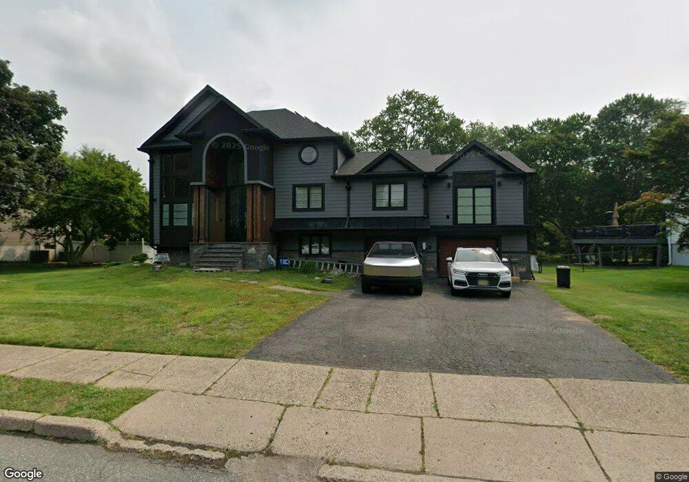
This home is located at 40 Andover Dr, Wayne, NJ 07470 and is currently estimated at $966,498, approximately $540 per square foot. 40 Andover Dr is a home located in Passaic County with nearby schools including Lafayette Elementary School, Anthony Wayne Middle School, and Wayne Valley High School.
Ownership History
Date
Name
Owned For
Owner Type
Purchase Details
Closed on
Mar 22, 2007
Sold by
Hajjar George
Bought by
Almazi Nicole and Almazi Joseph
Current Estimated Value
Purchase Details
Closed on
Apr 13, 2005
Sold by
Greig Anthony
Bought by
Hajjar George
Home Financials for this Owner
Home Financials are based on the most recent Mortgage that was taken out on this home.
Original Mortgage
$359,000
Interest Rate
5.87%
Mortgage Type
New Conventional
Purchase Details
Closed on
Nov 30, 2001
Sold by
Yospe Mary
Bought by
Greig Anthony and Greig Carol
Home Financials for this Owner
Home Financials are based on the most recent Mortgage that was taken out on this home.
Original Mortgage
$275,000
Interest Rate
6.67%
Purchase Details
Closed on
Mar 2, 2000
Sold by
Yospe Mary
Bought by
Yospe Mary and Yospe Murray
Create a Home Valuation Report for This Property
The Home Valuation Report is an in-depth analysis detailing your home's value as well as a comparison with similar homes in the area
Home Values in the Area
Average Home Value in this Area
Purchase History
| Date | Buyer | Sale Price | Title Company |
|---|---|---|---|
| Almazi Nicole | $520,000 | -- | |
| Hajjar George | $535,000 | -- | |
| Greig Anthony | $369,000 | -- | |
| Yospe Mary | -- | -- |
Source: Public Records
Mortgage History
| Date | Status | Borrower | Loan Amount |
|---|---|---|---|
| Previous Owner | Hajjar George | $359,000 | |
| Previous Owner | Greig Anthony | $275,000 |
Source: Public Records
Tax History
| Year | Tax Paid | Tax Assessment Tax Assessment Total Assessment is a certain percentage of the fair market value that is determined by local assessors to be the total taxable value of land and additions on the property. | Land | Improvement |
|---|---|---|---|---|
| 2025 | $13,480 | $226,700 | $108,900 | $117,800 |
| 2024 | $12,963 | $226,700 | $108,900 | $117,800 |
| 2022 | $12,818 | $226,700 | $108,900 | $117,800 |
| 2021 | $12,804 | $226,700 | $108,900 | $117,800 |
| 2020 | $12,747 | $226,700 | $108,900 | $117,800 |
| 2019 | $12,500 | $226,700 | $108,900 | $117,800 |
| 2018 | $12,389 | $226,700 | $108,900 | $117,800 |
| 2017 | $12,276 | $226,700 | $108,900 | $117,800 |
| 2016 | $12,104 | $226,700 | $108,900 | $117,800 |
| 2015 | $11,958 | $226,700 | $108,900 | $117,800 |
| 2014 | $11,621 | $226,700 | $108,900 | $117,800 |
Source: Public Records
Map
Nearby Homes
Your Personal Tour Guide
Ask me questions while you tour the home.