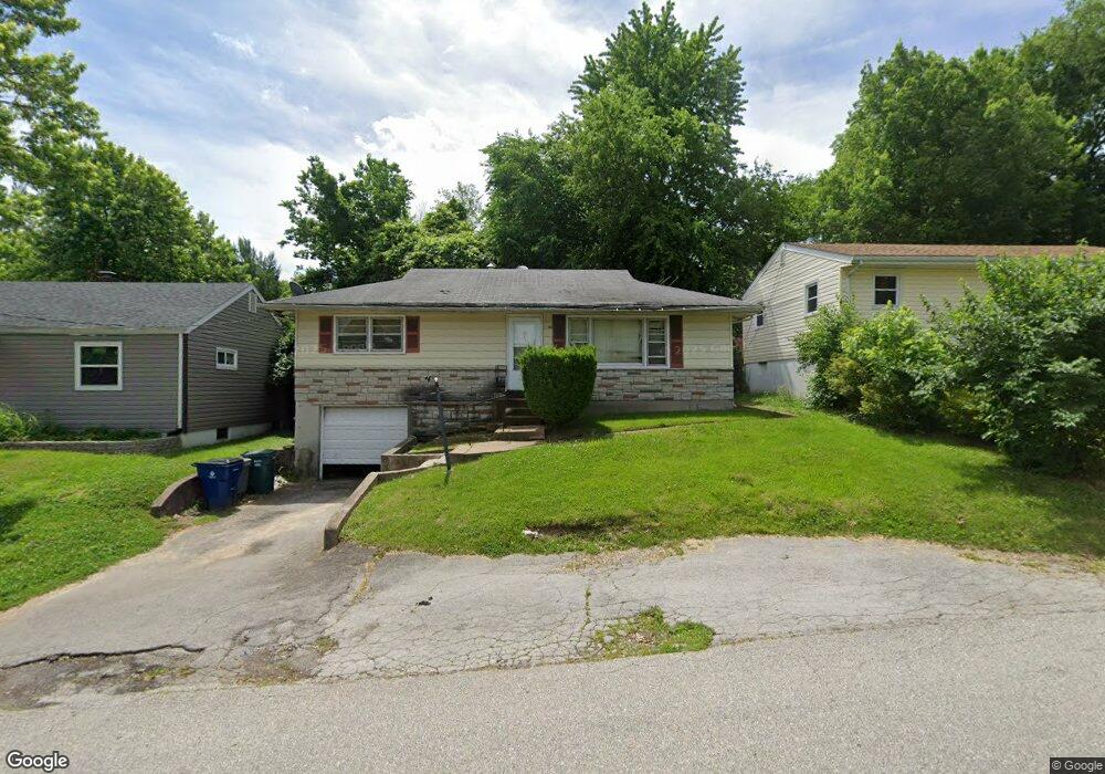
40 Bascom Dr Saint Louis, MO 63135
Estimated Value: $85,000 - $120,000
3
Beds
1
Bath
1,040
Sq Ft
$99/Sq Ft
Est. Value
About This Home
This home is located at 40 Bascom Dr, Saint Louis, MO 63135 and is currently estimated at $103,148, approximately $99 per square foot. 40 Bascom Dr is a home located in St. Louis County with nearby schools including Walnut Grove Elementary School, Ferguson Middle School, and McCluer High School.
Ownership History
Date
Name
Owned For
Owner Type
Purchase Details
Closed on
Jun 29, 2004
Sold by
Brown Timothy and Brown Angela
Bought by
Tunstall Veronica
Current Estimated Value
Home Financials for this Owner
Home Financials are based on the most recent Mortgage that was taken out on this home.
Original Mortgage
$70,290
Outstanding Balance
$37,868
Interest Rate
7.55%
Mortgage Type
Purchase Money Mortgage
Estimated Equity
$65,280
Purchase Details
Closed on
Mar 31, 2000
Sold by
Va
Bought by
Brown Timothy and Brown Angela
Home Financials for this Owner
Home Financials are based on the most recent Mortgage that was taken out on this home.
Original Mortgage
$43,500
Interest Rate
8%
Mortgage Type
Seller Take Back
Purchase Details
Closed on
Feb 24, 1999
Sold by
Njr Fitzgerald Paul and Njr Jacqueline
Bought by
Va
Create a Home Valuation Report for This Property
The Home Valuation Report is an in-depth analysis detailing your home's value as well as a comparison with similar homes in the area
Home Values in the Area
Average Home Value in this Area
Purchase History
| Date | Buyer | Sale Price | Title Company |
|---|---|---|---|
| Tunstall Veronica | $78,100 | -- | |
| Brown Timothy | $44,000 | -- | |
| Va | $44,207 | -- |
Source: Public Records
Mortgage History
| Date | Status | Borrower | Loan Amount |
|---|---|---|---|
| Open | Tunstall Veronica | $70,290 | |
| Previous Owner | Brown Timothy | $43,500 | |
| Closed | Tunstall Veronica | $4,400 |
Source: Public Records
Tax History
| Year | Tax Paid | Tax Assessment Tax Assessment Total Assessment is a certain percentage of the fair market value that is determined by local assessors to be the total taxable value of land and additions on the property. | Land | Improvement |
|---|---|---|---|---|
| 2025 | $1,174 | $21,740 | $1,960 | $19,780 |
| 2024 | $1,174 | $14,820 | $780 | $14,040 |
| 2023 | $1,170 | $14,820 | $780 | $14,040 |
| 2022 | $1,134 | $12,600 | $2,340 | $10,260 |
| 2021 | $1,130 | $12,600 | $2,340 | $10,260 |
| 2020 | $1,116 | $11,570 | $1,580 | $9,990 |
| 2019 | $1,095 | $11,570 | $1,580 | $9,990 |
| 2018 | $1,068 | $10,110 | $1,220 | $8,890 |
| 2017 | $1,062 | $10,110 | $1,220 | $8,890 |
| 2016 | $1,168 | $10,850 | $1,980 | $8,870 |
| 2015 | $1,174 | $10,850 | $1,980 | $8,870 |
| 2014 | $1,174 | $11,230 | $1,940 | $9,290 |
Source: Public Records
Map
Nearby Homes
- 25 Vierling Dr
- 181 Bascom Dr
- 194 Elbring Dr
- 135 Grether Ave
- 13 Barto Dr
- 18 White Dr
- 16 White Dr
- 1825 S New Florissant Rd
- 201 Becker Dr
- 968 Buckeye Dr
- 1815 S New Florissant Rd
- 215 Ryan Ave
- 273 Buddie Ave
- 242 Connolly Dr
- 233 Connolly Dr
- 6801 Knoll Ave
- 211 Frost Ave
- 6717 Thurston Ave
- 11 S Duchesne Dr
- 6637 Torlina Dr
Your Personal Tour Guide
Ask me questions while you tour the home.