R
Seller's Agent in 2025
Reza Abbassi
New Door Realty
(860) 874-5466
7 in this area
87 Total Sales
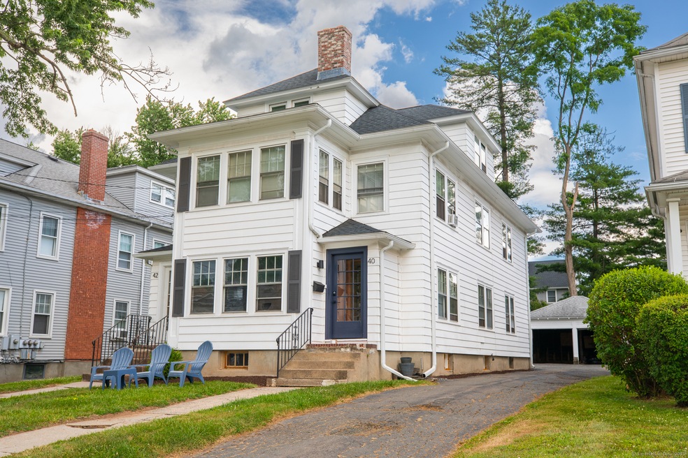
Welcome to 40 Bretton Road, a well-maintained income-producing three-family home located just a short walk from West Hartford Center. This versatile property offers two fully rented units on the first and second floors, with a vacant third-floor apartment ready for an owner-occupant or new tenants, providing flexible living options. The home features classic charm with updated systems, spacious layouts, and excellent curb appeal. Its prime location offers convenience and walkability to shops, restaurants, parks, and amenities in the vibrant West Hartford community. Whether you're an investor seeking immediate rental income or an owner looking to live in one unit while generating income from others, this property offers great potential. Don't miss the opportunity to own a well-maintained, income-generating home in a desirable neighborhood.
Last Agent to Sell the Property
New Door Realty License #REB.0793381 Listed on: 07/18/2025
| Date | Type | Sale Price | Title Company |
|---|---|---|---|
| Warranty Deed | $720,000 | -- | |
| Warranty Deed | $450,000 | None Available | |
| Warranty Deed | $450,000 | None Available | |
| Quit Claim Deed | $131,023 | -- | |
| Quit Claim Deed | $131,023 | -- |
| Date | Status | Loan Amount | Loan Type |
|---|---|---|---|
| Previous Owner | $441,849 | FHA | |
| Previous Owner | $85,160 | Purchase Money Mortgage |
| Date | Event | Price | List to Sale | Price per Sq Ft |
|---|---|---|---|---|
| 08/15/2025 08/15/25 | Sold | $720,000 | 0.0% | $192 / Sq Ft |
| 07/26/2025 07/26/25 | Pending | -- | -- | -- |
| 07/26/2025 07/26/25 | For Sale | $720,000 | -- | $192 / Sq Ft |
| Year | Tax Paid | Tax Assessment Tax Assessment Total Assessment is a certain percentage of the fair market value that is determined by local assessors to be the total taxable value of land and additions on the property. | Land | Improvement |
|---|---|---|---|---|
| 2025 | $13,676 | $305,410 | $90,720 | $214,690 |
| 2024 | $12,934 | $305,410 | $90,720 | $214,690 |
| 2023 | $12,497 | $305,410 | $90,720 | $214,690 |
| 2022 | $12,424 | $305,410 | $90,720 | $214,690 |
| 2021 | $12,549 | $295,820 | $101,360 | $194,460 |
| 2020 | $11,359 | $271,740 | $89,810 | $181,930 |
| 2019 | $11,359 | $271,740 | $89,810 | $181,930 |
| 2018 | $11,141 | $271,740 | $89,810 | $181,930 |
| 2017 | $11,152 | $271,740 | $89,810 | $181,930 |
| 2016 | $9,409 | $238,140 | $77,280 | $160,860 |
| 2015 | $9,123 | $238,140 | $77,280 | $160,860 |
| 2014 | $8,899 | $238,140 | $77,280 | $160,860 |
R
Seller's Agent in 2025
Reza Abbassi
New Door Realty
(860) 874-5466
7 in this area
87 Total Sales
Source: SmartMLS
MLS Number: 24112781
APN: WHAR-000008G-000621-000040
Disclaimer: Certain information contained herein is derived from information provided by parties other than Homes.com. All information provided is deemed reliable, but is not guaranteed to be accurate and should be independently verified.
![]() IDX information is provided exclusively for personal, non-commercial use, and may not be used for any purpose other than to identify prospective properties consumers may be interested in purchasing. Information is deemed reliable but not guaranteed.
IDX information is provided exclusively for personal, non-commercial use, and may not be used for any purpose other than to identify prospective properties consumers may be interested in purchasing. Information is deemed reliable but not guaranteed.
