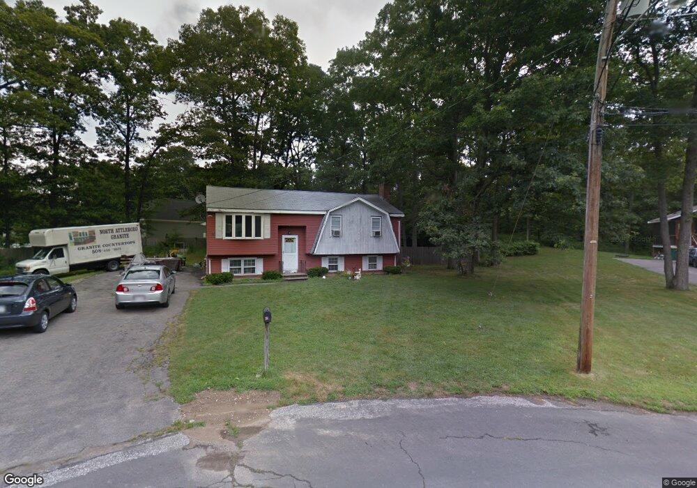
40 Brick Kiln Rd North Attleboro, MA 02760
North Attleboro NeighborhoodEstimated Value: $514,000 - $571,000
3
Beds
2
Baths
1,080
Sq Ft
$500/Sq Ft
Est. Value
About This Home
This home is located at 40 Brick Kiln Rd, North Attleboro, MA 02760 and is currently estimated at $540,028, approximately $500 per square foot. 40 Brick Kiln Rd is a home located in Bristol County with nearby schools including North Attleboro High School.
Ownership History
Date
Name
Owned For
Owner Type
Purchase Details
Closed on
Feb 17, 2004
Sold by
Bray Michele L
Bought by
Bray Paul and Bray Mary
Current Estimated Value
Home Financials for this Owner
Home Financials are based on the most recent Mortgage that was taken out on this home.
Original Mortgage
$185,000
Outstanding Balance
$86,704
Interest Rate
5.82%
Estimated Equity
$453,324
Purchase Details
Closed on
Jun 5, 2001
Sold by
Bray Paul A and Bray Mary F
Bought by
Bray \Michele L
Home Financials for this Owner
Home Financials are based on the most recent Mortgage that was taken out on this home.
Original Mortgage
$156,750
Interest Rate
7.09%
Mortgage Type
Purchase Money Mortgage
Create a Home Valuation Report for This Property
The Home Valuation Report is an in-depth analysis detailing your home's value as well as a comparison with similar homes in the area
Home Values in the Area
Average Home Value in this Area
Purchase History
| Date | Buyer | Sale Price | Title Company |
|---|---|---|---|
| Bray Paul | -- | -- | |
| Bray \Michele L | $209,000 | -- |
Source: Public Records
Mortgage History
| Date | Status | Borrower | Loan Amount |
|---|---|---|---|
| Open | Bray Paul | $185,000 | |
| Previous Owner | Bray \Michele L | $156,750 | |
| Previous Owner | Bray \Michele L | $116,250 |
Source: Public Records
Tax History Compared to Growth
Tax History
| Year | Tax Paid | Tax Assessment Tax Assessment Total Assessment is a certain percentage of the fair market value that is determined by local assessors to be the total taxable value of land and additions on the property. | Land | Improvement |
|---|---|---|---|---|
| 2025 | $5,204 | $441,400 | $158,400 | $283,000 |
| 2024 | $4,980 | $431,500 | $158,400 | $273,100 |
| 2023 | $5,216 | $407,800 | $158,400 | $249,400 |
| 2022 | $5,065 | $363,600 | $158,400 | $205,200 |
| 2021 | $4,925 | $345,100 | $158,400 | $186,700 |
| 2020 | $4,803 | $334,700 | $158,400 | $176,300 |
| 2019 | $4,595 | $322,700 | $144,000 | $178,700 |
| 2018 | $4,105 | $307,700 | $144,000 | $163,700 |
| 2017 | $3,928 | $297,100 | $144,000 | $153,100 |
| 2016 | $3,758 | $284,300 | $152,100 | $132,200 |
| 2015 | $3,520 | $267,900 | $152,100 | $115,800 |
| 2014 | $3,293 | $248,700 | $133,400 | $115,300 |
Source: Public Records
Map
Nearby Homes
- 3 Serengeti Dr
- 12 Houde St
- 1066 Mount Hope St
- 212 Fisher St Unit A5
- 217 Fisher St
- 8 Al Pace Dr Unit 8
- 64 Smith St
- Lot 2 Jeffrey Dr
- Lot 5 Jeffrey Dr
- 633 E Washington St Unit 17
- 633 E Washington St Unit 10
- 711 Mount Hope St Unit 7
- 711 Mount Hope St Unit 6
- 711 Mount Hope St Unit 8
- 711 Mount Hope St Unit 5
- 711 Mount Hope St Unit 12
- 711 Mount Hope St Unit 9
- 711 Mount Hope St Unit 11
- 711 Mount Hope St Unit 10
- 711 Mount Hope St Unit 16