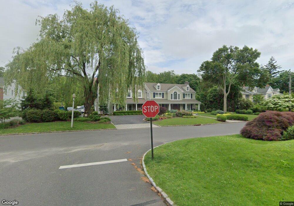
40 Brookside Dr Manhasset, NY 11030
Estimated Value: $6,079,605 - $6,322,000
Studio
8
Baths
7,742
Sq Ft
$801/Sq Ft
Est. Value
About This Home
This home is located at 40 Brookside Dr, Manhasset, NY 11030 and is currently estimated at $6,200,803, approximately $800 per square foot. 40 Brookside Dr is a home located in Nassau County with nearby schools including Manhasset Secondary School, St Mary's Elementary School, and Happy Montessori School.
Ownership History
Date
Name
Owned For
Owner Type
Purchase Details
Closed on
Jan 7, 2008
Sold by
Molinari Jeffrey
Bought by
Rielly Stephen
Current Estimated Value
Purchase Details
Closed on
Jul 31, 1995
Sold by
Regan John and Regan Lillian
Bought by
Molinari Jeffrey and Molinari Paula
Home Financials for this Owner
Home Financials are based on the most recent Mortgage that was taken out on this home.
Original Mortgage
$712,500
Interest Rate
7.48%
Create a Home Valuation Report for This Property
The Home Valuation Report is an in-depth analysis detailing your home's value as well as a comparison with similar homes in the area
Home Values in the Area
Average Home Value in this Area
Purchase History
| Date | Buyer | Sale Price | Title Company |
|---|---|---|---|
| Rielly Stephen | $3,525,000 | -- | |
| Molinari Jeffrey | $1,712,500 | -- |
Source: Public Records
Mortgage History
| Date | Status | Borrower | Loan Amount |
|---|---|---|---|
| Previous Owner | Molinari Jeffrey | $712,500 |
Source: Public Records
Tax History
| Year | Tax Paid | Tax Assessment Tax Assessment Total Assessment is a certain percentage of the fair market value that is determined by local assessors to be the total taxable value of land and additions on the property. | Land | Improvement |
|---|---|---|---|---|
| 2025 | $38,813 | $3,408 | $1,547 | $1,861 |
| 2024 | $4,975 | $3,420 | $1,552 | $1,868 |
| 2023 | $34,028 | $3,929 | $1,783 | $2,146 |
| 2022 | $34,028 | $3,854 | $1,749 | $2,105 |
| 2021 | $27,677 | $4,100 | $1,563 | $2,537 |
| 2020 | $24,647 | $4,935 | $3,943 | $992 |
| 2019 | $34,453 | $5,288 | $3,961 | $1,327 |
| 2018 | $34,743 | $5,640 | $0 | $0 |
| 2017 | $29,509 | $5,993 | $3,223 | $2,770 |
| 2016 | $36,391 | $6,345 | $3,412 | $2,933 |
| 2015 | $9,969 | $7,856 | $4,225 | $3,631 |
| 2014 | $9,969 | $7,856 | $4,225 | $3,631 |
| 2013 | $9,404 | $7,786 | $4,225 | $3,561 |
Source: Public Records
Map
Nearby Homes
- 50 South Dr
- 2 Stonytown Rd
- 44 North Dr
- 88 Plandome Ct
- 64 Plandome Ct
- 1054 Plandome Rd
- 6 Janssen Dr
- 59 Colonial Dr
- 97 Vanderbilt Ave
- 54 Summit Dr
- 107 Bayview Rd
- 539 Manhasset Woods Rd
- 71 Beechwood Ave
- 38 Mason Dr
- 350 Dogwood Ln
- 11 Muriel Rd
- 13 Chanticlare Dr
- 138 Hillcrest Ave
- 191 Elderfields Rd
- 27 Oakland Dr
- 36 Brookside Dr
- 36 Brookside Dr
- 44 Brookside Dr
- 37 Brookside Dr
- 43 Brookside Dr
- 86 South Dr
- 30 Brookside Dr
- 46 Brookside Dr
- 77 Westgate Blvd
- 82 South Dr
- 51 Brookside Dr
- 54 Brookside Dr
- 73 Westgate Blvd
- 78 Westgate Blvd
- 80 South Dr
- 20 Brookside Dr
- 70 Westgate Blvd
- 58 Brookside Dr
- 69 Westgate Blvd
- 49 Central Dr
Your Personal Tour Guide
Ask me questions while you tour the home.