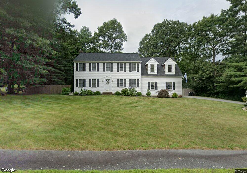
40 Captain Nathaniel Dr Hanson, MA 02341
Estimated Value: $758,927 - $909,000
5
Beds
4
Baths
2,340
Sq Ft
$348/Sq Ft
Est. Value
About This Home
This home is located at 40 Captain Nathaniel Dr, Hanson, MA 02341 and is currently estimated at $814,982, approximately $348 per square foot. 40 Captain Nathaniel Dr is a home located in Plymouth County.
Ownership History
Date
Name
Owned For
Owner Type
Purchase Details
Closed on
Dec 31, 1997
Sold by
Collamore Ests Rt and Konish William D
Bought by
Sartori David N and Sartori Bonnie M
Current Estimated Value
Purchase Details
Closed on
Jun 16, 1989
Sold by
Chase William J
Bought by
Sartori David N
Create a Home Valuation Report for This Property
The Home Valuation Report is an in-depth analysis detailing your home's value as well as a comparison with similar homes in the area
Home Values in the Area
Average Home Value in this Area
Purchase History
| Date | Buyer | Sale Price | Title Company |
|---|---|---|---|
| Sartori David N | $198,900 | -- | |
| Sartori David N | $125,000 | -- |
Source: Public Records
Mortgage History
| Date | Status | Borrower | Loan Amount |
|---|---|---|---|
| Open | Sartori David N | $90,000 | |
| Closed | Sartori David N | $30,000 |
Source: Public Records
Tax History
| Year | Tax Paid | Tax Assessment Tax Assessment Total Assessment is a certain percentage of the fair market value that is determined by local assessors to be the total taxable value of land and additions on the property. | Land | Improvement |
|---|---|---|---|---|
| 2025 | $8,387 | $626,800 | $191,800 | $435,000 |
| 2024 | $8,221 | $614,400 | $186,300 | $428,100 |
| 2023 | $8,000 | $564,200 | $186,300 | $377,900 |
| 2022 | $7,744 | $513,200 | $169,300 | $343,900 |
| 2021 | $7,005 | $463,900 | $162,800 | $301,100 |
| 2020 | $6,904 | $452,100 | $157,300 | $294,800 |
| 2019 | $6,849 | $441,000 | $169,000 | $272,000 |
| 2018 | $6,767 | $427,500 | $162,500 | $265,000 |
| 2017 | $6,560 | $410,500 | $154,700 | $255,800 |
| 2016 | $6,638 | $401,100 | $154,700 | $246,400 |
| 2015 | $6,285 | $394,800 | $154,700 | $240,100 |
Source: Public Records
Map
Nearby Homes
- 724 Whitman St
- Lot 5 Princeton Way
- 84 Liberty St
- 139 Fairwood Dr
- 22 Howland Trail Unit 34
- 17 Hayford Trail Unit 12
- 7 Hayford Trail Unit 12
- 5 Hayford Trail Unit 11
- 26 Stonebridge Dr
- 108 Waterford Dr
- 23 Live Oak Way
- 430 Brook Bend Rd
- 161 Winter St Unit 11
- 361 County Rd
- 361A County Rd
- 10 Proud Foot Way
- Lot 6 Way
- 10 Birch Bottom Cir
- 214 Winter St
- 95 Tecumseh Dr
- 22 Captain Nathaniel Dr
- 64 Captain Nathaniel Dr
- 18 Capt Nathaniel Dr
- 35 Captain Nathaniel Dr
- 53 Captain Nathaniel Dr
- 8 Capt Nathaniel Dr
- 473 Whitman St
- 86 Captain Nathaniel Dr
- 3 Capt Nathaniel Dr
- 71 Captain Nathaniel Dr
- 118 Lexington St
- 469 Whitman St
- 524 Whitman St
- 140 Captain Nathaniel Dr
- 470 Whitman St
- 163 Captain Nathaniel Dr
- 100 Lexington St
- 534 Whitman St
- 464 Whitman St
- 451 Whitman St
Your Personal Tour Guide
Ask me questions while you tour the home.