
Seller's Agent in 2026
Lisa Gordon
Coldwell Banker Realty
(860) 805-7722
4 in this area
180 Total Sales
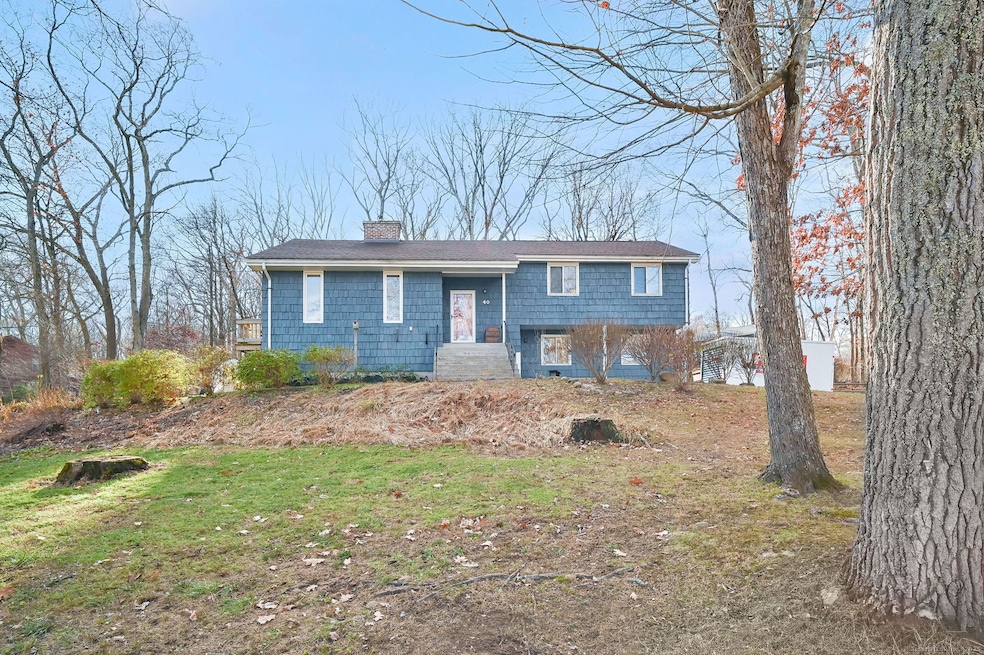
Open & Airy Multi-Level Home in a Picture-Perfect Neighborhood! Step inside this inviting, light-filled home featuring vaulted ceilings, multi-level living, and a dramatic floor to ceiling brick fireplace that creates an unforgettable focal point. The living room boasts a cozy pellet stove, perfect for keeping warm all winter, and flows effortlessly into the dining room and kitchen, creating an ideal layout for everyday living and entertaining. A charming side balcony offers the perfect spot to enjoy morning coffee and fresh air. The kitchen features freshly painted white cabinets with space for a dinette or island, while the dining room showcases wood-beam accents, views of the fireplace, and sliders leading to the deck-a great extension of your living space outdoors. On the main level, you'll find three bedrooms, including a primary suite with an updated private half bath. The main full bath has been tastefully updated with a tiled shower, a new vanity, and modern light fixtures. The lower walkout level offers additional living space, including a cozy family room with a whitewashed fireplace, a half bathroom combined with laundry, and convenient garage access. Outside, enjoy the spacious yard, perfect for play and relaxation-plus an upscale chicken coop ready for your feathered friends! Recent big-ticket updates include a brand-new furnace, new roof, and updated chimney for peace of mind. All in a setting that you will love coming home to! Highest & Best EOD Thursday 12/4
Last Agent to Sell the Property
Coldwell Banker Realty Brokerage Phone: (860) 805-7722 License #RES.0773156 Listed on: 11/26/2025
| Date | Type | Sale Price | Title Company |
|---|---|---|---|
| Warranty Deed | $405,000 | -- | |
| Warranty Deed | $193,700 | -- | |
| Warranty Deed | $193,700 | -- |
| Date | Status | Loan Amount | Loan Type |
|---|---|---|---|
| Open | $390,521 | New Conventional | |
| Previous Owner | $193,700 | Purchase Money Mortgage | |
| Previous Owner | $4,700 | No Value Available |
| Date | Event | Price | List to Sale | Price per Sq Ft |
|---|---|---|---|---|
| 01/08/2026 01/08/26 | Sold | $405,000 | +12.5% | $242 / Sq Ft |
| 12/06/2025 12/06/25 | Pending | -- | -- | -- |
| 12/01/2025 12/01/25 | For Sale | $359,900 | -- | $215 / Sq Ft |
| Year | Tax Paid | Tax Assessment Tax Assessment Total Assessment is a certain percentage of the fair market value that is determined by local assessors to be the total taxable value of land and additions on the property. | Land | Improvement |
|---|---|---|---|---|
| 2025 | $5,389 | $226,800 | $60,700 | $166,100 |
| 2024 | $4,727 | $141,900 | $50,200 | $91,700 |
| 2023 | $4,504 | $141,900 | $50,200 | $91,700 |
| 2022 | $4,420 | $141,900 | $50,200 | $91,700 |
| 2021 | $4,420 | $141,900 | $50,200 | $91,700 |
| 2020 | $4,423 | $141,900 | $50,200 | $91,700 |
| 2019 | $4,572 | $142,000 | $50,200 | $91,800 |
| 2018 | $4,295 | $133,400 | $50,200 | $83,200 |
| 2017 | $4,269 | $133,400 | $50,200 | $83,200 |
| 2016 | $4,162 | $133,400 | $50,200 | $83,200 |
| 2015 | $4,162 | $133,400 | $50,200 | $83,200 |
| 2014 | $4,302 | $151,100 | $60,800 | $90,300 |
Seller's Agent in 2026
Lisa Gordon
Coldwell Banker Realty
(860) 805-7722
4 in this area
180 Total Sales
Buyer's Agent in 2026
Kimberly Mauro
Coldwell Banker Realty
(860) 644-2461
1 in this area
54 Total Sales
Source: SmartMLS
MLS Number: 24142273
APN: COVE-000000-B000028-000082
Disclaimer: Certain information contained herein is derived from information provided by parties other than Homes.com. All information provided is deemed reliable, but is not guaranteed to be accurate and should be independently verified.
![]() IDX information is provided exclusively for personal, non-commercial use, and may not be used for any purpose other than to identify prospective properties consumers may be interested in purchasing. Information is deemed reliable but not guaranteed.
IDX information is provided exclusively for personal, non-commercial use, and may not be used for any purpose other than to identify prospective properties consumers may be interested in purchasing. Information is deemed reliable but not guaranteed.
Ask me questions while you tour the home.