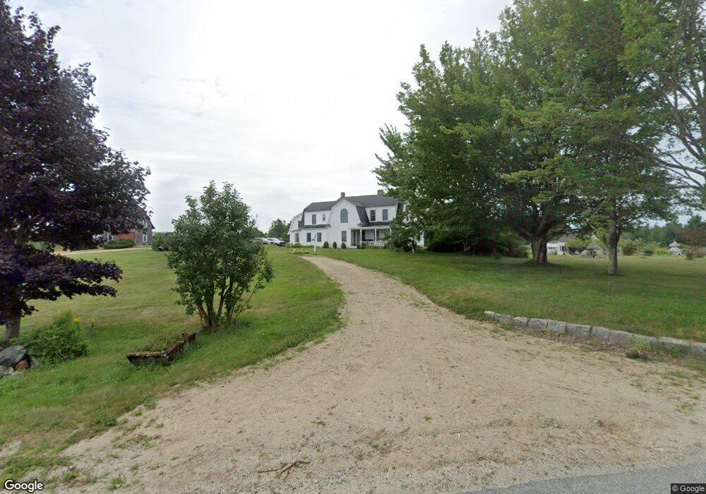
40 Dunham Point Rd Deer Isle, ME 04627
Estimated Value: $410,000 - $667,813
--
Bed
--
Bath
1,392
Sq Ft
$376/Sq Ft
Est. Value
About This Home
This home is located at 40 Dunham Point Rd, Deer Isle, ME 04627 and is currently estimated at $523,953, approximately $376 per square foot. 40 Dunham Point Rd is a home with nearby schools including Deer Isle-Stonington Elementary School and Deer Isle-Stonington High School.
Ownership History
Date
Name
Owned For
Owner Type
Purchase Details
Closed on
Aug 2, 2024
Sold by
Kydd Claudette O
Bought by
Claudette O Kydd Ret and Kydd
Current Estimated Value
Purchase Details
Closed on
Jul 31, 2024
Sold by
Kydd Loring S
Bought by
Kydd Claudette O
Create a Home Valuation Report for This Property
The Home Valuation Report is an in-depth analysis detailing your home's value as well as a comparison with similar homes in the area
Home Values in the Area
Average Home Value in this Area
Purchase History
| Date | Buyer | Sale Price | Title Company |
|---|---|---|---|
| Claudette O Kydd Ret | -- | None Available | |
| Claudette O Kydd Ret | -- | None Available | |
| Kydd Claudette O | -- | None Available | |
| Kydd Claudette O | -- | None Available |
Source: Public Records
Tax History Compared to Growth
Tax History
| Year | Tax Paid | Tax Assessment Tax Assessment Total Assessment is a certain percentage of the fair market value that is determined by local assessors to be the total taxable value of land and additions on the property. | Land | Improvement |
|---|---|---|---|---|
| 2024 | $4,595 | $531,800 | $210,400 | $321,400 |
| 2023 | $4,297 | $531,800 | $210,400 | $321,400 |
| 2022 | $4,121 | $531,800 | $210,400 | $321,400 |
| 2021 | $4,068 | $531,800 | $210,400 | $321,400 |
| 2020 | $3,133 | $151,000 | $46,400 | $104,600 |
| 2019 | $3,039 | $140,700 | $46,400 | $94,300 |
| 2018 | $3,088 | $140,700 | $46,400 | $94,300 |
| 2017 | $2,990 | $140,700 | $46,400 | $94,300 |
| 2016 | $2,955 | $140,700 | $46,400 | $94,300 |
| 2015 | $3,081 | $140,700 | $46,400 | $94,300 |
| 2014 | $3,108 | $136,200 | $46,400 | $89,800 |
| 2013 | $3,108 | $136,200 | $46,400 | $89,800 |
Source: Public Records
Map
Nearby Homes
- 113 Pressey Village Rd
- 15 SW Harbor Rd
- 31 Pressey Village Rd
- 005-054 Bridge St
- Sheephead Island
- Lot 001 Sheephead Island
- 13 Dow Rd
- 41 Church St
- 0 Quaco Rd Unit 1625807
- 191 Sunset Cross Rd
- M3L66&66-2 Sunset Cross Rd
- 36 Treasure Ln
- 27 Spofford Dr
- 17 Barbour Farm Rd
- 145 Stanley Field Rd
- 594 N Deer Isle Rd
- 36 Greenlaw District Rd
- 18 Davids Way
- 30 Hardys Hill Rd
- 70 Owens Way
- 20 Dunham Point Rd
- 43 Dunham Point Rd
- 16 Dunham Point Rd
- 66 Dunham Point Rd
- 0 Dunham Point Rd Unit 969559
- 0 Dunham Point Rd Unit 997984
- 0 Dunham's Point Rd Unit 1055543
- 0 Dunham Point Rd Unit 1055539
- 511 Pressey Village Rd
- 0 Perez Cross Rd Unit 1055914
- 42 Perez Crossroad
- 54 Perez Crossroad
- 1 Dunham Point Rd
- Lot #77 Perez Cross Rd
- 00 Perez Crossroad
- 252 Pressey Village Rd
- 76 Atkins Ln
- Lot 77 Perez Cross Rd
- 257 Pressey Village Rd
- 253 Pressey Village Rd