R
Seller's Agent in 2025
Robert Fichtel
LAER Realty Partners
(978) 827-6303
9 in this area
18 Total Sales
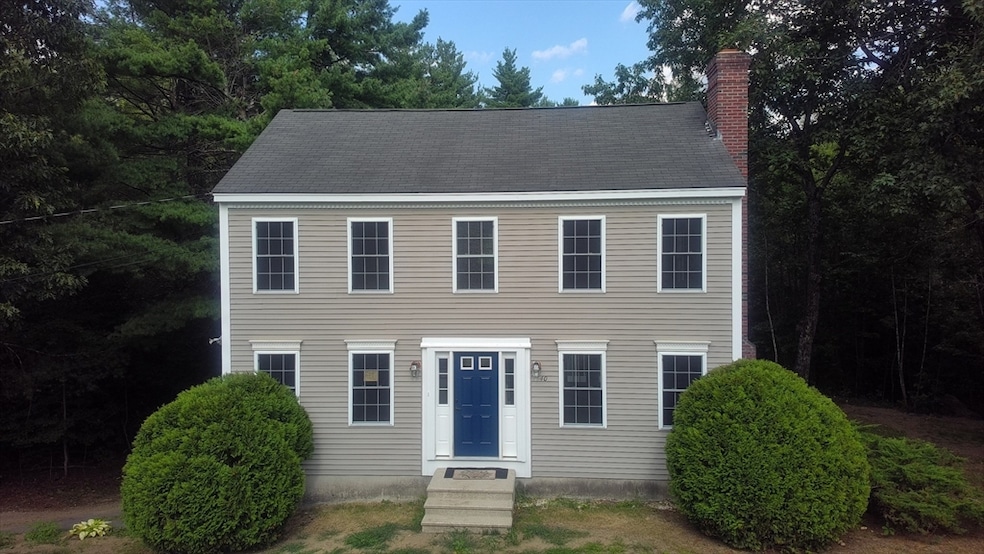
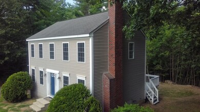

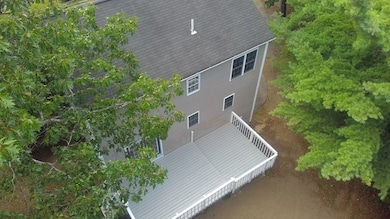
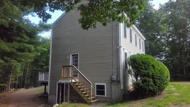
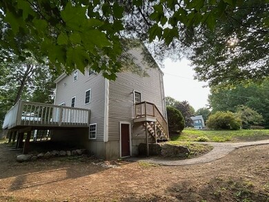
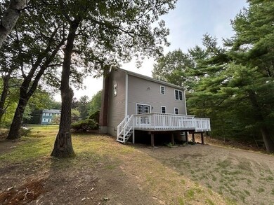
Sitting on a large 3.96 acre lot in a quiet neighborhood with plenty of privacy and abutting conservation land. Its convenient location is right off Rt. 12 and close to Rt. 140. The property offers a blend of practical design and tranquil surroundings. House is move in ready with fresh paint, refinished hardwood floors, and new ceramic tile. Nothing to do but sit back and enjoy your new home. Large front to back living room with fire place and direct access to the privacy of your back deck looking out into the forest behind. Additionally there's a partially finished office/playroom in the cellar. Beyond the interior, the expansive almost 4 acre lot offers restful solitude for outdoor enjoyment and is ready for your creative landscaping. Envision creating an inviting patio for al fresco dining, or simply reveling in the beauty and serenity of the surrounding landscape. Brand new boiler! Don't let this one slip by. Ready for immediate occupancy!
| Date | Event | Price | List to Sale | Price per Sq Ft |
|---|---|---|---|---|
| 12/23/2025 12/23/25 | Sold | $485,000 | -0.8% | $303 / Sq Ft |
| 11/20/2025 11/20/25 | Pending | -- | -- | -- |
| 10/22/2025 10/22/25 | Price Changed | $489,000 | -2.0% | $306 / Sq Ft |
| 09/26/2025 09/26/25 | For Sale | $499,000 | 0.0% | $312 / Sq Ft |
| 09/21/2025 09/21/25 | Pending | -- | -- | -- |
| 09/15/2025 09/15/25 | Price Changed | $499,000 | -3.9% | $312 / Sq Ft |
| 08/19/2025 08/19/25 | For Sale | $519,000 | -- | $324 / Sq Ft |
| Year | Tax Paid | Tax Assessment Tax Assessment Total Assessment is a certain percentage of the fair market value that is determined by local assessors to be the total taxable value of land and additions on the property. | Land | Improvement |
|---|---|---|---|---|
| 2025 | $5,096 | $342,700 | $52,300 | $290,400 |
| 2024 | $4,883 | $310,000 | $52,200 | $257,800 |
| 2023 | $4,775 | $288,500 | $47,600 | $240,900 |
| 2022 | $5,016 | $265,700 | $45,900 | $219,800 |
| 2021 | $4,985 | $242,600 | $45,900 | $196,700 |
| 2020 | $4,876 | $242,600 | $45,900 | $196,700 |
| 2019 | $4,467 | $212,700 | $45,900 | $166,800 |
| 2018 | $4,736 | $202,400 | $43,600 | $158,800 |
| 2017 | $4,541 | $197,700 | $40,800 | $156,900 |
| 2016 | $4,450 | $195,600 | $40,200 | $155,400 |
R
Seller's Agent in 2025
Robert Fichtel
LAER Realty Partners
(978) 827-6303
9 in this area
18 Total Sales

Buyer's Agent in 2025
Kara Strunjo
Real Broker MA, LLC
(978) 895-3157
1 in this area
52 Total Sales
Source: MLS Property Information Network (MLS PIN)
MLS Number: 73419877
APN: ASHB M:0014 B:000083
Disclaimer: Certain information contained herein is derived from information provided by parties other than Homes.com. All information provided is deemed reliable, but is not guaranteed to be accurate and should be independently verified.
![]() The property listing data and information, or the Images, set forth herein were provided to MLS Property Information Network, Inc. from third party sources, including sellers, lessors and public records, and were compiled by MLS Property Information Network, Inc. The property listing data and information, and the Images, are for the personal, non-commercial use of consumers having a good faith interest in purchasing or leasing listed properties of the type displayed to them and may not be used for any purpose other than to identify prospective properties which such consumers may have a good faith interest in purchasing or leasing. MLS Property Information Network, Inc. and its subscribers disclaim any and all representations and warranties as to the accuracy of the property listing data and information, or as to the accuracy of any of the Images, set forth herein.
The property listing data and information, or the Images, set forth herein were provided to MLS Property Information Network, Inc. from third party sources, including sellers, lessors and public records, and were compiled by MLS Property Information Network, Inc. The property listing data and information, and the Images, are for the personal, non-commercial use of consumers having a good faith interest in purchasing or leasing listed properties of the type displayed to them and may not be used for any purpose other than to identify prospective properties which such consumers may have a good faith interest in purchasing or leasing. MLS Property Information Network, Inc. and its subscribers disclaim any and all representations and warranties as to the accuracy of the property listing data and information, or as to the accuracy of any of the Images, set forth herein.
Ask me questions while you tour the home.