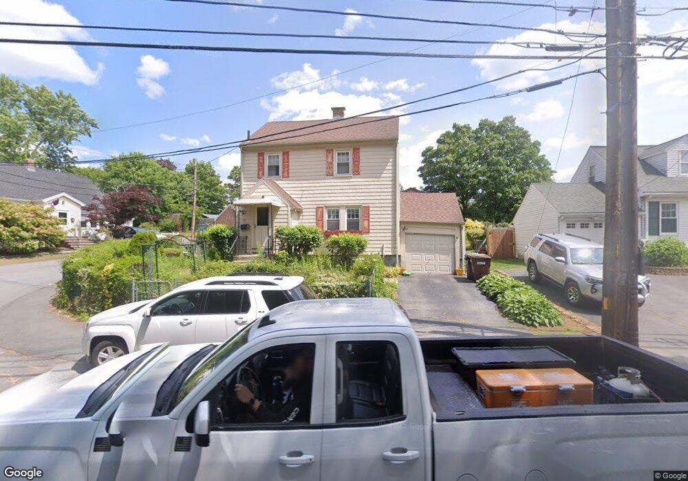
40 Lower East St Dedham, MA 02026
East Dedham NeighborhoodEstimated Value: $644,000 - $731,000
3
Beds
1
Bath
1,248
Sq Ft
$550/Sq Ft
Est. Value
About This Home
This home is located at 40 Lower East St, Dedham, MA 02026 and is currently estimated at $685,899, approximately $549 per square foot. 40 Lower East St is a home located in Norfolk County with nearby schools including Avery, Dedham Middle School, and Dedham High School.
Ownership History
Date
Name
Owned For
Owner Type
Purchase Details
Closed on
Mar 10, 2025
Sold by
Olympia Rt and Moniz
Bought by
Moniz Mary M and Pennie Robert L
Current Estimated Value
Purchase Details
Closed on
Sep 30, 2016
Sold by
Moniz Mary M
Bought by
Olympia Rt and Moniz
Purchase Details
Closed on
Nov 1, 1994
Sold by
Pelletier Nancy P and Pelletier Richard E
Bought by
Montz Mary M
Home Financials for this Owner
Home Financials are based on the most recent Mortgage that was taken out on this home.
Original Mortgage
$101,000
Interest Rate
8.65%
Mortgage Type
Purchase Money Mortgage
Create a Home Valuation Report for This Property
The Home Valuation Report is an in-depth analysis detailing your home's value as well as a comparison with similar homes in the area
Home Values in the Area
Average Home Value in this Area
Purchase History
| Date | Buyer | Sale Price | Title Company |
|---|---|---|---|
| Moniz Mary M | -- | None Available | |
| Moniz Mary M | -- | None Available | |
| Olympia Rt | -- | -- | |
| Olympia Rt | -- | -- | |
| Montz Mary M | $116,000 | -- | |
| Montz Mary M | $116,000 | -- |
Source: Public Records
Mortgage History
| Date | Status | Borrower | Loan Amount |
|---|---|---|---|
| Previous Owner | Montz Mary M | $61,000 | |
| Previous Owner | Montz Mary M | $94,000 | |
| Previous Owner | Montz Mary M | $99,000 | |
| Previous Owner | Montz Mary M | $101,000 |
Source: Public Records
Tax History Compared to Growth
Tax History
| Year | Tax Paid | Tax Assessment Tax Assessment Total Assessment is a certain percentage of the fair market value that is determined by local assessors to be the total taxable value of land and additions on the property. | Land | Improvement |
|---|---|---|---|---|
| 2025 | $7,068 | $560,100 | $255,900 | $304,200 |
| 2024 | $6,940 | $555,200 | $242,300 | $312,900 |
| 2023 | $6,225 | $484,800 | $215,100 | $269,700 |
| 2022 | $5,951 | $445,800 | $210,600 | $235,200 |
| 2021 | $5,672 | $414,900 | $206,000 | $208,900 |
| 2020 | $5,532 | $403,200 | $196,900 | $206,300 |
| 2019 | $5,149 | $363,900 | $171,300 | $192,600 |
| 2018 | $5,039 | $346,300 | $153,700 | $192,600 |
| 2017 | $4,807 | $325,700 | $144,100 | $181,600 |
| 2016 | $4,828 | $311,700 | $125,800 | $185,900 |
| 2015 | $4,534 | $285,700 | $117,900 | $167,800 |
| 2014 | $4,398 | $273,500 | $115,200 | $158,300 |
Source: Public Records
Map
Nearby Homes
- 235 Curve St
- 25R Rockland St Unit 6
- 57 Rockland St
- 5245 Washington St Unit 5
- 94 Rockland St
- 70 Birchwood St
- 83 Mount Hope St
- 199 Glenellen Rd
- 191 Glenellen Rd
- 11 Cheriton Rd Unit 102B
- 8 Fort Ln
- 110 New Haven St
- 42 Churchill Place
- 150 Grove St
- 2 Cocci Way
- 55 Cottage Rd
- 115 Grove St Unit 11
- 111 Grove St Unit 6
- 321 East St
- 108 High St