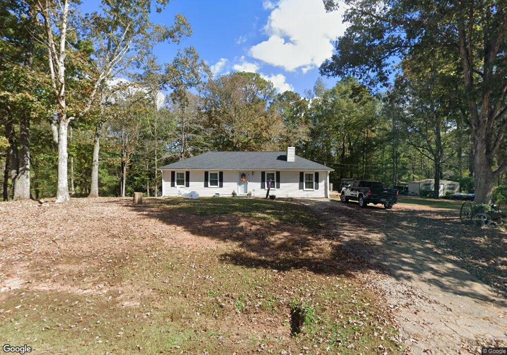
40 Maefield Dr Lagrange, GA 30240
Estimated Value: $154,953 - $186,000
3
Beds
2
Baths
1,336
Sq Ft
$128/Sq Ft
Est. Value
About This Home
This home is located at 40 Maefield Dr, Lagrange, GA 30240 and is currently estimated at $170,988, approximately $127 per square foot. 40 Maefield Dr is a home located in Troup County with nearby schools including Long Cane Elementary School, Berta Weathersbee Elementary School, and Whitesville Road Elementary School.
Ownership History
Date
Name
Owned For
Owner Type
Purchase Details
Closed on
Aug 30, 2021
Sold by
Heath Michael D
Bought by
Pittman John Monroe and Pittman Faye Melissa
Current Estimated Value
Home Financials for this Owner
Home Financials are based on the most recent Mortgage that was taken out on this home.
Original Mortgage
$97,375
Outstanding Balance
$72,275
Interest Rate
2.8%
Mortgage Type
New Conventional
Estimated Equity
$98,713
Purchase Details
Closed on
Oct 5, 1998
Sold by
Barbara Siterlet
Bought by
Heath Michael D and Heath Laura J
Purchase Details
Closed on
Dec 8, 1993
Sold by
Butler L
Bought by
Barbara Siterlet
Purchase Details
Closed on
Feb 18, 1992
Sold by
Jones Cheryl
Bought by
Butler L
Purchase Details
Closed on
Sep 5, 1980
Bought by
Jones Cheryl
Purchase Details
Closed on
Nov 27, 1979
Purchase Details
Closed on
Jul 16, 1979
Purchase Details
Closed on
Jul 1, 1979
Purchase Details
Closed on
Sep 25, 1978
Purchase Details
Closed on
May 30, 1975
Create a Home Valuation Report for This Property
The Home Valuation Report is an in-depth analysis detailing your home's value as well as a comparison with similar homes in the area
Purchase History
| Date | Buyer | Sale Price | Title Company |
|---|---|---|---|
| Pittman John Monroe | $102,500 | -- | |
| Heath Michael D | $69,900 | -- | |
| Barbara Siterlet | $54,000 | -- | |
| Butler L | -- | -- | |
| Jones Cheryl | -- | -- | |
| -- | $39,200 | -- | |
| -- | -- | -- | |
| -- | $4,500 | -- | |
| -- | -- | -- | |
| -- | -- | -- |
Source: Public Records
Mortgage History
| Date | Status | Borrower | Loan Amount |
|---|---|---|---|
| Open | Pittman John Monroe | $97,375 |
Source: Public Records
Tax History
| Year | Tax Paid | Tax Assessment Tax Assessment Total Assessment is a certain percentage of the fair market value that is determined by local assessors to be the total taxable value of land and additions on the property. | Land | Improvement |
|---|---|---|---|---|
| 2025 | $1,414 | $60,456 | $6,560 | $53,896 |
| 2024 | $1,086 | $41,816 | $6,560 | $35,256 |
| 2023 | $1,083 | $41,696 | $6,560 | $35,136 |
| 2022 | $1,061 | $40,016 | $6,560 | $33,456 |
| 2021 | $1,093 | $36,240 | $6,560 | $29,680 |
| 2020 | $1,093 | $36,240 | $6,560 | $29,680 |
| 2019 | $1,132 | $37,520 | $6,560 | $30,960 |
| 2018 | $898 | $29,760 | $6,560 | $23,200 |
| 2017 | $898 | $29,760 | $6,560 | $23,200 |
| 2016 | $874 | $28,984 | $6,560 | $22,424 |
| 2015 | $839 | $27,789 | $6,560 | $21,229 |
| 2014 | $807 | $26,672 | $6,560 | $20,112 |
| 2013 | -- | $27,985 | $6,560 | $21,425 |
Source: Public Records
Map
Nearby Homes
- 105 Redwood Dr
- 3009 Old West Point Rd
- 0 Glass Bridge Rd Unit 10679358
- 22 Freeman Rd
- 640 Hudson Rd
- 266 Glass Bridge Rd
- 288 Bradfield Dr
- 808 S Fling Rd
- 2239 Pegasus Pkwy
- 0 Bradfield Dr Unit 10568803
- 112 Foxdale Dr
- 8 Horace Carter Rd
- 509 Connie Dr
- 427 Fling Rd
- 119 Plymouth Dr
- 102 Bridgewater Dr
- 402 Ginger Cir
- 113 Colonial Ct Unit 100
- 311 Cumberland Dr
- 124 Lincoln Ln
- 147 Rob Roy Rd
- 49 Maefield Dr
- 145 Rob Roy Rd
- 5042 Old West Point Rd
- 35 Maefield Dr
- 5040 Old West Point Rd
- 76 Maefield Dr
- 6000 Old West Point Rd
- 55 Maefield Dr
- 146 Rob Roy Rd
- 5038 Old West Point Rd
- 143 Rob Roy Rd
- 6002 Old West Point Rd
- 5036 Old West Point Rd
- 5036 Old Point W
- 6004 Old West Point Rd
- 142 Rob Roy Rd
- 5043 Old West Point Rd
- 5041 Old West Point Rd
- 5037 Old West Point Rd
Your Personal Tour Guide
Ask me questions while you tour the home.