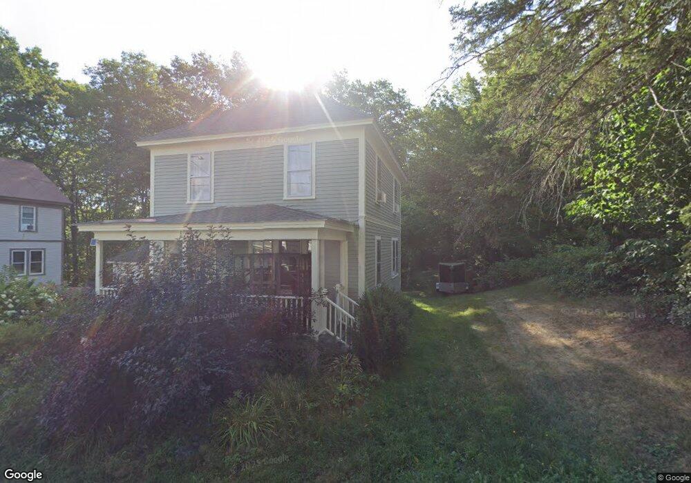
40 Maple St Limerick, ME 04048
Estimated Value: $331,287 - $366,000
3
Beds
1
Bath
880
Sq Ft
$392/Sq Ft
Est. Value
About This Home
This home is located at 40 Maple St, Limerick, ME 04048 and is currently estimated at $344,572, approximately $391 per square foot. 40 Maple St is a home located in York County with nearby schools including Massabesic High School and Ossipee Valley Christian School.
Ownership History
Date
Name
Owned For
Owner Type
Purchase Details
Closed on
May 10, 2006
Sold by
Newell Lawrence A
Bought by
Roberts Elizabeth A and Roberts David E
Current Estimated Value
Home Financials for this Owner
Home Financials are based on the most recent Mortgage that was taken out on this home.
Original Mortgage
$142,400
Outstanding Balance
$81,568
Interest Rate
6.4%
Mortgage Type
Purchase Money Mortgage
Estimated Equity
$263,004
Create a Home Valuation Report for This Property
The Home Valuation Report is an in-depth analysis detailing your home's value as well as a comparison with similar homes in the area
Home Values in the Area
Average Home Value in this Area
Purchase History
| Date | Buyer | Sale Price | Title Company |
|---|---|---|---|
| Roberts Elizabeth A | -- | -- |
Source: Public Records
Mortgage History
| Date | Status | Borrower | Loan Amount |
|---|---|---|---|
| Open | Roberts Elizabeth A | $142,400 | |
| Closed | Roberts Elizabeth A | $35,600 |
Source: Public Records
Tax History
| Year | Tax Paid | Tax Assessment Tax Assessment Total Assessment is a certain percentage of the fair market value that is determined by local assessors to be the total taxable value of land and additions on the property. | Land | Improvement |
|---|---|---|---|---|
| 2025 | $2,731 | $287,422 | $71,400 | $216,022 |
| 2024 | $2,699 | $284,107 | $71,400 | $212,707 |
| 2023 | $2,354 | $154,890 | $35,750 | $119,140 |
| 2022 | $2,199 | $154,890 | $35,750 | $119,140 |
| 2021 | $2,057 | $123,912 | $28,600 | $95,312 |
| 2020 | $4,494 | $123,912 | $28,600 | $95,312 |
| 2019 | $1,952 | $123,912 | $28,600 | $95,312 |
| 2018 | $4,296 | $123,912 | $28,600 | $95,312 |
| 2017 | $3,876 | $123,912 | $28,600 | $95,312 |
| 2016 | $1,865 | $123,912 | $28,600 | $95,312 |
| 2015 | $1,809 | $123,912 | $28,600 | $95,312 |
| 2014 | $1,753 | $123,912 | $28,600 | $95,312 |
Source: Public Records
Map
Nearby Homes
- 5 Wescott St
- 0 Quarry Rd
- 24 Emery Corner Rd
- 16 Whiteley Rd
- 71 Quarry Rd
- 110 Pleasant Hill Rd
- 87 Pleasant Hill Rd
- 14 Pleasant Hill Rd
- LOT# 8 Business Park Rd
- Lot# 11 Business Park Rd
- 4 Deer Crossing Rd
- 6 Moose Dr
- 175 Deer Crossing Rd
- 240 Leisure Ln
- 8 & 40 Durgin Farm Rd
- 48 King Hill Rd
- 50 Island Rd
- 0 Stone Hill Rd
- 26 Old Country Way
- MP42LT232 Nob Hill Rd
Your Personal Tour Guide
Ask me questions while you tour the home.