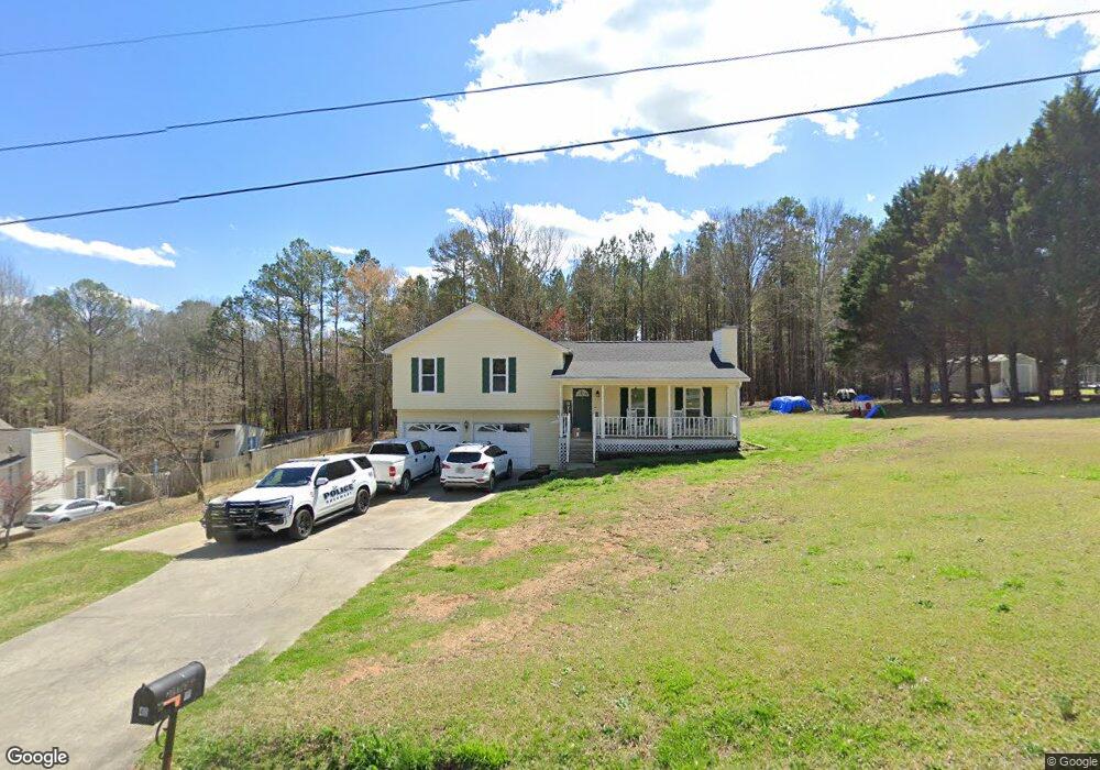
40 Paula Ct Cedartown, GA 30125
Estimated Value: $229,000 - $285,000
3
Beds
2
Baths
1,375
Sq Ft
$187/Sq Ft
Est. Value
About This Home
This home is located at 40 Paula Ct, Cedartown, GA 30125 and is currently estimated at $256,922, approximately $186 per square foot. 40 Paula Ct is a home located in Polk County.
Ownership History
Date
Name
Owned For
Owner Type
Purchase Details
Closed on
Dec 22, 2020
Sold by
Golden Frank T
Bought by
Golden Frank T and Huff Mary Elizabeth
Current Estimated Value
Purchase Details
Closed on
Sep 25, 2020
Sold by
Golden Travis K
Bought by
Golden Frank T
Home Financials for this Owner
Home Financials are based on the most recent Mortgage that was taken out on this home.
Original Mortgage
$106,700
Interest Rate
2.9%
Mortgage Type
New Conventional
Purchase Details
Closed on
May 24, 2002
Sold by
Farrister Ralph Scott and Terry Marie
Bought by
Golden Travis K
Purchase Details
Closed on
Jul 14, 1997
Sold by
Montgomery Thomas L
Bought by
Farrister Ralph Scott and Terry Marie
Purchase Details
Closed on
Jan 31, 1997
Sold by
Igel Lusia Trustee
Bought by
Montgomery Thomas L
Purchase Details
Closed on
Dec 31, 1996
Sold by
Liverant Jacob
Bought by
Montgomery Thomas L
Purchase Details
Closed on
Apr 14, 1995
Sold by
Igel Stanley
Bought by
Igel Stanley Living Trust (Stanley Igel
Purchase Details
Closed on
Oct 30, 1973
Sold by
Adams Charles W
Bought by
Igel Stanley
Create a Home Valuation Report for This Property
The Home Valuation Report is an in-depth analysis detailing your home's value as well as a comparison with similar homes in the area
Home Values in the Area
Average Home Value in this Area
Purchase History
| Date | Buyer | Sale Price | Title Company |
|---|---|---|---|
| Golden Frank T | -- | -- | |
| Golden Frank T | $110,000 | -- | |
| Golden Travis K | $94,400 | -- | |
| Farrister Ralph Scott | $78,000 | -- | |
| Montgomery Thomas L | $6,300 | -- | |
| Montgomery Thomas L | $6,300 | -- | |
| Igel Stanley Living Trust (Stanley Igel | -- | -- | |
| Igel Stanley | -- | -- |
Source: Public Records
Mortgage History
| Date | Status | Borrower | Loan Amount |
|---|---|---|---|
| Previous Owner | Golden Frank T | $106,700 |
Source: Public Records
Tax History Compared to Growth
Tax History
| Year | Tax Paid | Tax Assessment Tax Assessment Total Assessment is a certain percentage of the fair market value that is determined by local assessors to be the total taxable value of land and additions on the property. | Land | Improvement |
|---|---|---|---|---|
| 2024 | $1,864 | $91,171 | $16,000 | $75,171 |
| 2023 | $1,500 | $65,212 | $16,000 | $49,212 |
| 2022 | $1,033 | $45,530 | $2,800 | $42,730 |
| 2021 | $1,095 | $45,530 | $2,800 | $42,730 |
| 2020 | $1,097 | $45,530 | $2,800 | $42,730 |
| 2019 | $1,157 | $43,080 | $4,000 | $39,080 |
| 2018 | $1,098 | $39,844 | $4,000 | $35,844 |
| 2017 | $1,084 | $39,844 | $4,000 | $35,844 |
| 2016 | $1,084 | $39,844 | $4,000 | $35,844 |
| 2015 | $1,104 | $40,436 | $4,000 | $36,436 |
| 2014 | $1,098 | $41,945 | $4,082 | $37,862 |
Source: Public Records
Map
Nearby Homes
- 424 Michael Blvd
- 383 Valley Grove Rd
- 100 Lee Ave
- 0 Cave Spring Rd Unit 10631588
- 0 Cave Spring Rd Unit 7671027
- 600 Miller Rd
- 1200 N Cave Spring St
- 727 Cherokee Rd
- 39 Summerwind Dr
- 217 Cherokee Cir
- 208 Silverthorn Way
- LOT 21 Cherokee Cir
- 828 N College Dr
- 88 Sequoyah Ct
- 621 N College Dr
- 113 Cherokee Estates Dr
- 00 Oak Crest Dr
- 521 W John Hand Rd
- 232 Stephens Rd
- 112 College Cir
- 24 Paula Ct
- 41 Paula Ct
- 23 Paula Ct
- 21 Paula Ct
- 591 Michael Blvd
- 623 Michael Blvd
- 519 Michael Blvd
- 612 Michael Blvd
- 491 Michael Blvd
- 480 Michael Blvd
- 401 Michael Blvd
- 403 Michael Blvd
- 36 Jenni Ln
- 620 Michael Blvd
- 391 Michael Blvd
- 421 Michael Blvd
- 51 Jenni Ln
- 522 Michael Blvd
- 337 Valley Grove Rd
- 20 Jenni Ln