NOT LISTED FOR SALE

40 S 1st E Driggs, ID 83422

Estimated Value: $617,000

0.18 Acre
$3,427,778 Price per Acre
7,841 Sq Ft Lot

Last Sold December 01, 2017

Current estimated payment $3,306/month

5 Days on Market

Highlights

  • Mountain View
  • No HOA
  • Level Lot

About This Lot

As of December 2017

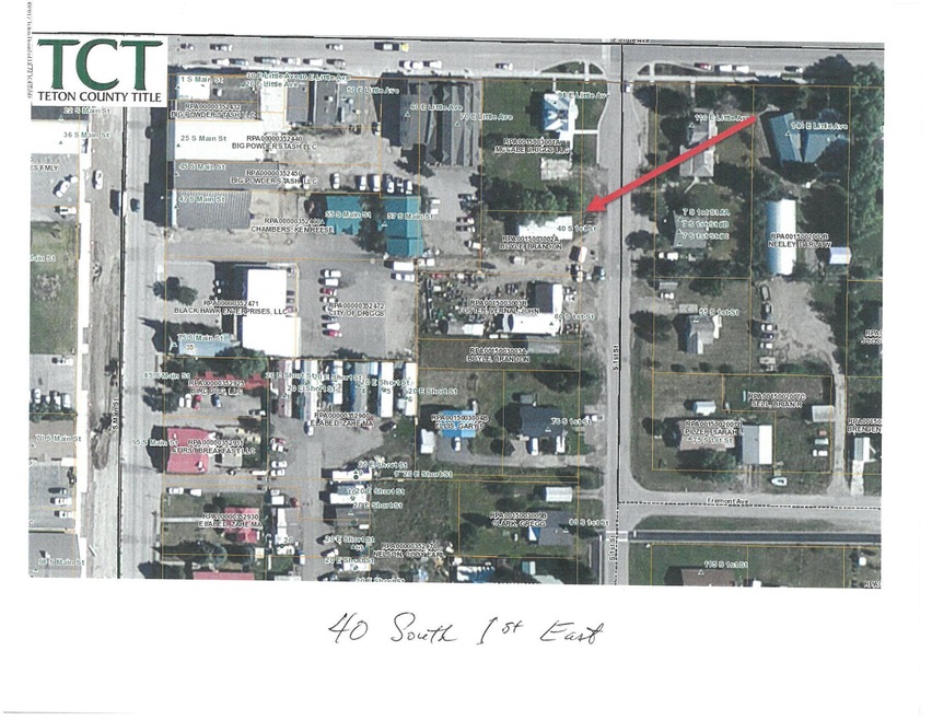
Well located near the Driggs Downtown Core, this commercial lot fronts on 1st South Street East for 70 feet, is Zoned DX Downtown Mixed Use, subject to both Downtown Parking and Design Review Overlays. A Public Parking is located not adjacent, but just to the SW in the center of Block, behind Blackhawk Building. Existing 1969 doublewide mobile home currently leases the lot and a presumed month to month basis, unless written lease is produced.

Last Agent to Sell the Property

Mark Rockefeller

Teton Valley Realty License #753 Listed on: 11/11/2017

Last Buyer's Agent

Mark Rockefeller

Teton Valley Realty License #753 Listed on: 11/11/2017

Property Details

Property Type

  • Land

Est. Annual Taxes

  • $888

Year Built

  • 1969

Lot Details

  • 7,841 Sq Ft Lot
  • Year Round Access
  • Level Lot
  • Zoning described as Commercial

Property Views

  • Mountain Views

Utilities

  • Electricity To Lot Line
  • Phone Available

Community Details

  • No Home Owners Association

Listing and Financial Details

  • Assessor Parcel Number RPA0015003002A

Property Details

Property Type

Land

Est. Annual Taxes

$888

Year Built

1969

Lot Details

0

Listing Details

  • Prop. Type: Building Site
  • Horses: No
  • Lot Size Acres: 0.18
  • Road Surface Type: Paved
  • Subdivision Name: None
  • Directions: From Driggs traffic light, east on Little Ave one block, turn South, second property on right.
  • Property Info:Horses Allowed: No
  • Property Features:Flat: Yes
  • Property Features:Year Round Access: Yes
  • View:Mountain View: Yes
  • Property Info:_pound_ Horses Allowed: 0
  • Sale Status:Potential Short Sale: No
  • Property Features:Electric to Property: Yes
  • Property Features:Phone to Lot Line: Yes
  • Water:Public: Yes
  • Sewer:Public2: Yes
  • Special Features: None
  • Property Sub Type: LotsLands
  • Year Built (Public Record): 1969

Exterior Features

  • Lot Features: Year Round Access, Level
  • View: Mountain(s)

Utilities

  • Electricity On Property: Yes
  • Sewer: Public Sewer
  • Utilities: Phone to Lot Line
  • Water Source: Public

Condo/Co-op/Association

  • Association: No

Lot Info

  • Lot Size Sq Ft: 7840.8
  • Parcel #: RPA0015003002A
  • Zoning Description: Commercial
  • ResoLotSizeUnits: Acres

Tax Info

  • Tax Annual Amount: 888.0
  • Tax Year: 2016

Ownership History

Date Name Owned For Owner Type

Purchase Details

Closed on
Mar 11, 2021
Sold by
Kehl Jon A
Bought by
Weinbrandt Richard and Weinbrandt Trust
Total Days on Market
5
Current Estimated Value
$617,000

Purchase Details

Listed on
Nov 11, 2017
Closed on
Dec 2, 2017
Sold by
Boyle Brandon
Bought by
Kehl Jon A
Seller's Agent
Mark Rockefeller
Teton Valley Realty
Buyer's Agent
Mark Rockefeller
Teton Valley Realty
List Price
$80,000
Sold Price
$70,000
Premium/Discount to List
-$10,000
-12.5%

Home Financials for this Owner

Home Financials are based on the most recent Mortgage that was taken out on this home.
Original Mortgage
$55,000
Interest Rate
3.88%
Mortgage Type
Commercial
Source: Public Records

Range of Values:

Collateral Analytics

Collateral Analytics Collateral Analytics AVMs (Automated Valuation Model) employ a number of statistical approaches combined with neighborhood-specific comparable selection guarantees the most up-to-date and precise valuations.

Not Available

Collateral Analytics does not have data for the current month. Please view the chart for historical values.

ICE

ICE Mortgage Technology ICE Mortgage Technology’s AVM (Automated Valuation Model) is a state-of-the-art online residential property valuation tool that provides a quick and accurate estimate of the value of almost any home in the U.S.

Not Available

ICE Mortgage Technology does not have data for the current month. Please view the chart for historical values.

First American

First American First American Data & Analytics’ next-generation AVM combines unrivaled data assets with a blended ensemble of valuation models to produce highly accurate, reliable valuations you can trust.

Not Available

First American does not have data for the current month. Please view the chart for historical values.

Quantarium

Quantarium Quantarium’s valuation service, repeatedly proven the industry’s most accurate and comprehensive, is supercharged with a self-learning and auto-tuning AI engine that continually becomes smarter and more accurate as it processes daily inputs from the industry’s leading RE data lake.

Not Available

Quantarium does not have data for the current month. Please view the chart for historical values.

Average Value
Not Available
List Price
Sold Price
Create a Home Valuation Report for This Property
The Home Valuation Report is an in-depth analysis detailing your home's value as well as a comparison with similar homes in the area

Home Values in the Area

Source: Public Records

Average Home Value in this Area


Source: Public Records

Purchase History

Date Buyer Sale Price Title Company
Weinbrandt Richard -- Alliance Title Driggs Office
Kehl Jon A -- Teton County Title
Source: Public Records

Mortgage History

Date Status Borrower Loan Amount
Previous Owner Kehl Jon A $55,000
Source: Public Records

Property History

Date Event Price Change Sq Ft Price
12/01/2017 12/01/17 Sold -- -- --
11/17/2017 11/17/17 Pending -- -- --
11/11/2017 11/11/17 For Sale $80,000 -- --
Source: Teton Board of REALTORS®

Tax History Compared to Growth

Source: Public Records

Tax History

Year Tax Paid Tax Assessment Tax Assessment Total Assessment is a certain percentage of the fair market value that is determined by local assessors to be the total taxable value of land and additions on the property. Land Improvement
2024 $383 $94,000 $94,000 $0
2023 $383 $94,000 $94,000 $0
2022 $211 $42,100 $42,100 $0
2021 $342 $42,100 $42,100 $0
2020 $417 $42,100 $42,100 $0
2019 $383 $39,000 $39,000 $0
2018 $415 $39,000 $39,000 $0
2017 $79 $39,000 $39,000 $0
2016 $888 $74,880 $21,680 $53,200
2015 $966 $74,880 $21,680 $53,200
2011 -- $72,106 $47,926 $24,180
Source: Public Records

Agents Affiliated with this Home

  • Section Image
See All Agents

Map

Source: Teton Board of REALTORS®

MLS Number: 17-3182

APN: RPA0015003002A