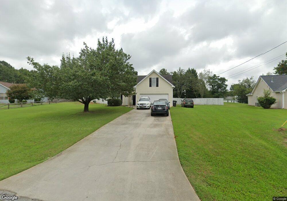
40 Sable Cir Covington, GA 30016
Estimated Value: $221,000 - $240,000
3
Beds
2
Baths
1,337
Sq Ft
$174/Sq Ft
Est. Value
About This Home
This home is located at 40 Sable Cir, Covington, GA 30016 and is currently estimated at $232,961, approximately $174 per square foot. 40 Sable Cir is a home located in Newton County with nearby schools including South Salem Elementary School, Liberty Middle School, and Alcovy High School.
Ownership History
Date
Name
Owned For
Owner Type
Purchase Details
Closed on
Sep 30, 2016
Sold by
Fannie Mae
Bought by
Docmars Enterprises Llc
Current Estimated Value
Purchase Details
Closed on
Jun 1, 2016
Sold by
Ditech Financial Llc
Bought by
Federal National Mortgage Association
Purchase Details
Closed on
May 3, 2016
Sold by
Beshears Michael Darrell
Bought by
Ditech Fiancial Llc
Purchase Details
Closed on
May 31, 1996
Sold by
Thompson Bldrsinc
Bought by
Beshears Michael Jennessa
Create a Home Valuation Report for This Property
The Home Valuation Report is an in-depth analysis detailing your home's value as well as a comparison with similar homes in the area
Home Values in the Area
Average Home Value in this Area
Purchase History
| Date | Buyer | Sale Price | Title Company |
|---|---|---|---|
| Docmars Enterprises Llc | $78,000 | -- | |
| Federal National Mortgage Association | $83,800 | -- | |
| Ditech Fiancial Llc | $83,800 | -- | |
| Beshears Michael Jennessa | $77,600 | -- |
Source: Public Records
Mortgage History
| Date | Status | Borrower | Loan Amount |
|---|---|---|---|
| Closed | Beshears Michael Jennessa | $0 |
Source: Public Records
Tax History
| Year | Tax Paid | Tax Assessment Tax Assessment Total Assessment is a certain percentage of the fair market value that is determined by local assessors to be the total taxable value of land and additions on the property. | Land | Improvement |
|---|---|---|---|---|
| 2025 | $2,298 | $92,360 | $14,000 | $78,360 |
| 2024 | $2,169 | $85,640 | $14,000 | $71,640 |
| 2023 | $2,251 | $82,960 | $6,000 | $76,960 |
| 2022 | $1,814 | $66,840 | $6,000 | $60,840 |
| 2021 | $1,618 | $53,360 | $6,000 | $47,360 |
| 2020 | $1,535 | $45,680 | $6,000 | $39,680 |
| 2019 | $1,362 | $39,920 | $6,000 | $33,920 |
| 2018 | $662 | $38,560 | $6,000 | $32,560 |
| 2017 | $1,232 | $35,880 | $6,000 | $29,880 |
| 2016 | $935 | $31,120 | $3,800 | $27,320 |
| 2015 | $819 | $27,760 | $3,200 | $24,560 |
| 2014 | $575 | $20,640 | $0 | $0 |
Source: Public Records
Map
Nearby Homes
- 415 Rosser Rd
- 275 Roberts Rd
- 417 Rosser Rd
- 75 Tulip Dr
- 615 St Annes Place
- 7 Glynnshire Ct
- 30 Freedom Ct
- 800 Mills Dr
- 50 Freedom Ct
- 115 Branchwood Dr
- 40 Freebia Walk
- 165 Tulip Dr
- 10 Logans Run
- 70 Countryside Ln
- 35 Charity Chase
- 113 St Annes Place
- 149 St Annes Place
- 161 Geranium Ln
- 45 Geranium Ln
- 100 Creekside Ln
- 50 Sable Cir Unit 3
- 30 Sable Cir
- 205 Falcon Ridge Dr Unit 1
- 55 Sable Cir Unit 3
- 60 Sable Cir
- 195 Falcon Ridge Dr Unit UN 1
- 195 Falcon Ridge Dr
- 215 Falcon Ridge Dr
- 70 Sable Cir
- 15 Sable Cir Unit 1
- 15 Sable Cir Unit 3
- 305 Sable Cir Unit 3
- 15 Falcons Crossing
- 85 Sable Cir Unit 3
- 185 Falcon Ridge Dr Unit 1
- 200 Falcon Ridge Dr Unit 1
- 220 Falcon Ridge Dr
- 80 Sable Cir Unit 3
- 330 Sable Cir Unit 3
- 285 Sable Cir Unit 3
Your Personal Tour Guide
Ask me questions while you tour the home.