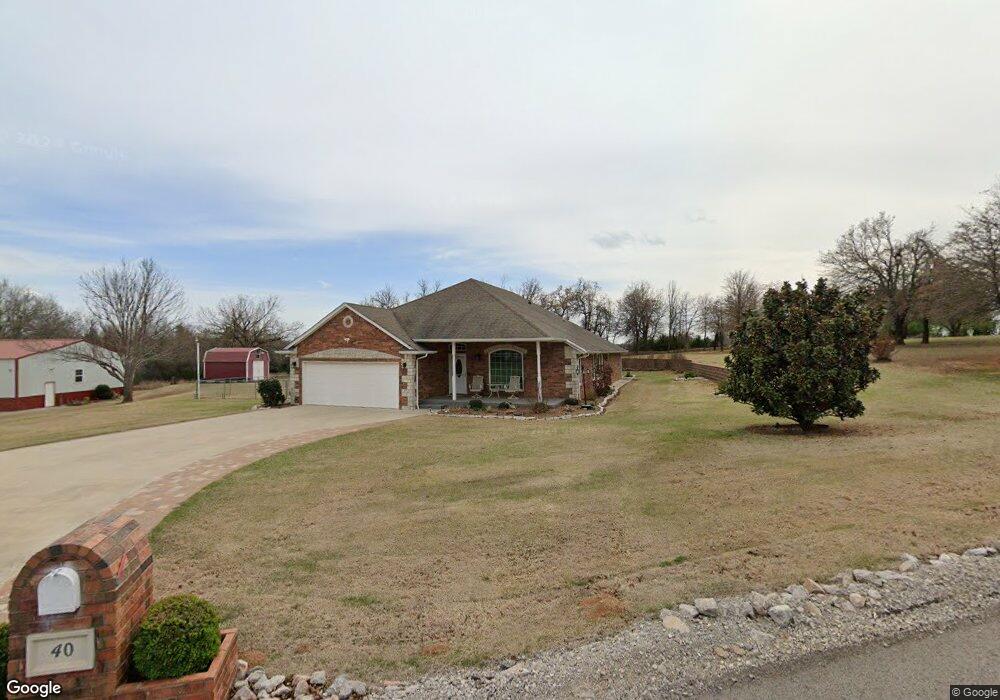
40 Shady Grove Rd McLoud, OK 74851
Estimated Value: $289,000 - $384,036
3
Beds
2
Baths
2,391
Sq Ft
$145/Sq Ft
Est. Value
About This Home
This home is located at 40 Shady Grove Rd, McLoud, OK 74851 and is currently estimated at $347,509, approximately $145 per square foot. 40 Shady Grove Rd is a home located in Pottawatomie County with nearby schools including McLoud Elementary School, McLoud Intermediate School, and McLoud Junior High School.
Ownership History
Date
Name
Owned For
Owner Type
Purchase Details
Closed on
Jun 10, 2015
Sold by
Mastagni Martin and Mastagni Cahtleen
Bought by
Mastagni Martin Allen and Mastagni Cathleen Kay
Current Estimated Value
Purchase Details
Closed on
Jul 18, 2006
Sold by
Mastagni Martin and Mastagni Cathleen
Bought by
Mastagni Martin and Mastagni Cathleen K
Home Financials for this Owner
Home Financials are based on the most recent Mortgage that was taken out on this home.
Original Mortgage
$172,700
Outstanding Balance
$101,500
Interest Rate
6.66%
Mortgage Type
New Conventional
Estimated Equity
$246,009
Purchase Details
Closed on
Aug 21, 2003
Sold by
Claude West Building Inc
Bought by
Mastagni Martin and Mastagni Cathlen
Purchase Details
Closed on
Sep 22, 1995
Sold by
The Bank Of Commerce
Bought by
Click Brian and Click Rhonda
Create a Home Valuation Report for This Property
The Home Valuation Report is an in-depth analysis detailing your home's value as well as a comparison with similar homes in the area
Home Values in the Area
Average Home Value in this Area
Purchase History
| Date | Buyer | Sale Price | Title Company |
|---|---|---|---|
| Mastagni Martin Allen | -- | None Available | |
| Mastagni Martin | -- | None Available | |
| Mastagni Martin | $195,500 | -- | |
| Click Brian | $6,000 | -- |
Source: Public Records
Mortgage History
| Date | Status | Borrower | Loan Amount |
|---|---|---|---|
| Open | Mastagni Martin | $172,700 |
Source: Public Records
Tax History
| Year | Tax Paid | Tax Assessment Tax Assessment Total Assessment is a certain percentage of the fair market value that is determined by local assessors to be the total taxable value of land and additions on the property. | Land | Improvement |
|---|---|---|---|---|
| 2025 | $2,397 | $27,948 | $1,251 | $26,697 |
| 2023 | $2,304 | $26,345 | $1,140 | $25,205 |
| 2022 | $2,336 | $26,345 | $1,140 | $25,205 |
| 2021 | $3,038 | $26,345 | $1,140 | $25,205 |
| 2020 | $2,360 | $26,589 | $1,140 | $25,449 |
| 2019 | $2,458 | $26,838 | $1,140 | $25,698 |
| 2018 | $2,634 | $27,082 | $1,140 | $25,942 |
| 2017 | $2,688 | $27,241 | $2,400 | $24,841 |
| 2016 | $2,334 | $26,447 | $2,400 | $24,047 |
| 2015 | $2,123 | $25,677 | $2,400 | $23,277 |
| 2014 | $2,123 | $24,929 | $2,400 | $22,529 |
Source: Public Records
Map
Nearby Homes
- 3129 Janet Ln Unit HAR
- 29805 SE 29th St
- 29353 Oklahoma St
- 113 Summer Oaks Dr
- 22072 Melissa Ln
- 3872 Ada Ave
- 3856 Ada Ave
- 3881 Ada Ave
- 29049 Oilfield Trash Rd
- 0 S Pottawatomie Rd
- 3864 Louthea Ln
- 3833 Dove Ave
- 10116 SE Pennington St
- 4629 Lincoln Landing
- 4332 Titan Terrace
- 4637 Lincoln Landing
- 3144 Pennington St
- 3128 Pennington St
- 3140 Pennington St
- 3120 Pennington St
- 44 Shady Grove Rd
- 33 Shady Grove Rd
- 23 Shady Grove Rd
- 38 Shady Grove Rd
- 46 Shady Grove Rd
- 34 Shady Grove Rd Unit MCL
- 32 Shady Grove Rd
- 24 Shady Grove Rd
- 4010 Bingham Dr
- 26 Shady Grove Rd
- 22 Shady Grove Rd
- 3930 Bingham Dr
- 11 Shady Grove Rd
- 0 Bingham Dr
- 30 Shady Grove Rd
- 3828 Bingham Dr
- 3828 Bingham Dr
- 4035 Bingham Dr
- 02 Bingham Dr
- 4101 Bingham Dr
Your Personal Tour Guide
Ask me questions while you tour the home.