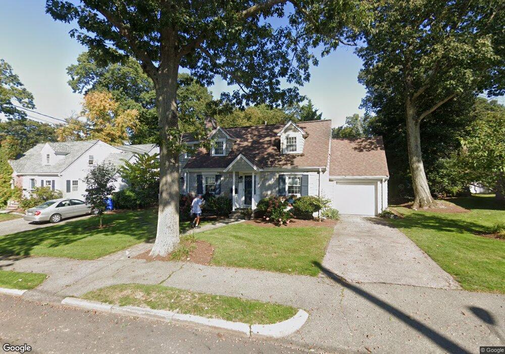
40 White Pine Rd Newton Upper Falls, MA 02464
Newton Upper Falls NeighborhoodEstimated Value: $1,401,000 - $1,685,000
4
Beds
4
Baths
2,479
Sq Ft
$598/Sq Ft
Est. Value
About This Home
This home is located at 40 White Pine Rd, Newton Upper Falls, MA 02464 and is currently estimated at $1,483,637, approximately $598 per square foot. 40 White Pine Rd is a home located in Middlesex County with nearby schools including Zervas Elementary School, Angier Elementary School, and Charles E Brown Middle School.
Ownership History
Date
Name
Owned For
Owner Type
Purchase Details
Closed on
Jun 24, 2019
Sold by
Catherine Hayes Ret and Hayes
Bought by
Hayes Cathareine
Current Estimated Value
Home Financials for this Owner
Home Financials are based on the most recent Mortgage that was taken out on this home.
Original Mortgage
$610,000
Outstanding Balance
$530,717
Interest Rate
4%
Mortgage Type
New Conventional
Estimated Equity
$952,920
Purchase Details
Closed on
Oct 9, 2013
Sold by
Hayes Catherine
Bought by
Catherine Hayes Ret and Hayes
Purchase Details
Closed on
Jun 22, 1995
Sold by
Tartaro Victor M and Miller-Tartaro Randi
Bought by
Hayes Catherine
Purchase Details
Closed on
Feb 20, 1990
Sold by
Tartaro Frank M
Bought by
Tartaro Victor M
Create a Home Valuation Report for This Property
The Home Valuation Report is an in-depth analysis detailing your home's value as well as a comparison with similar homes in the area
Home Values in the Area
Average Home Value in this Area
Purchase History
| Date | Buyer | Sale Price | Title Company |
|---|---|---|---|
| Hayes Cathareine | -- | -- | |
| Catherine Hayes Ret | -- | -- | |
| Catherine Hayes Ret | -- | -- | |
| Hayes Catherine | $245,000 | -- | |
| Tartaro Victor M | $185,000 | -- |
Source: Public Records
Mortgage History
| Date | Status | Borrower | Loan Amount |
|---|---|---|---|
| Open | Hayes Cathareine | $610,000 | |
| Previous Owner | Tartaro Victor M | $20,000 |
Source: Public Records
Tax History
| Year | Tax Paid | Tax Assessment Tax Assessment Total Assessment is a certain percentage of the fair market value that is determined by local assessors to be the total taxable value of land and additions on the property. | Land | Improvement |
|---|---|---|---|---|
| 2025 | $11,187 | $1,141,500 | $851,100 | $290,400 |
| 2024 | $10,817 | $1,108,300 | $826,300 | $282,000 |
| 2023 | $10,211 | $1,003,000 | $627,000 | $376,000 |
| 2022 | $9,770 | $928,700 | $580,600 | $348,100 |
| 2021 | $9,427 | $876,100 | $547,700 | $328,400 |
| 2020 | $9,146 | $876,100 | $547,700 | $328,400 |
| 2019 | $8,889 | $850,600 | $531,700 | $318,900 |
| 2018 | $6,743 | $623,200 | $478,700 | $144,500 |
| 2017 | $5,973 | $537,100 | $451,600 | $85,500 |
| 2016 | $5,713 | $502,000 | $422,100 | $79,900 |
| 2015 | $5,447 | $469,200 | $394,500 | $74,700 |
Source: Public Records
Map
Nearby Homes
- 29 Cottage St Unit 29
- 51 Pettee St Unit 31
- 5 Summer St
- 30 Circuit Ave Unit 30
- 302 Elliot St Carriage House N Unit 3
- 304 Elliot St Carriage House S Unit 4
- 1077 Boylston St Unit 1
- 300 Elliot St Unit 2
- 1003 Chestnut St
- 18 Josselyn Place Unit 18
- 16-18 Josselyn Place Unit 16
- 16-18 Josselyn Place Unit 18
- 12 Bemuth Rd
- 10 Pennsylvania Ave Unit 1
- 20 Pennsylvania Ave
- 20 Pennsylvania Ave Unit 20
- 873 Chestnut St
- 54 Indiana Terrace
- 27 Hamilton Place
- 829 Chestnut St
- 34 White Pine Rd
- 46 White Pine Rd
- 39 Hickory Cliff Rd
- 33 Hickory Cliff Rd
- 45 Hickory Cliff Rd
- 39 White Pine Rd
- 16 White Pine Rd
- 27 Hickory Cliff Rd
- 47 White Pine Rd
- 29 White Pine Rd
- 56 White Pine Rd
- 40 Hickory Cliff Rd
- 12 Tamarac Rd
- 46 Hickory Cliff Rd
- 55 White Pine Rd
- 32 Hickory Cliff Rd
- 140 Roundwood Rd
- 11 Tamarac Rd
- 24 Hickory Cliff Rd
- 15 White Pine Rd
Your Personal Tour Guide
Ask me questions while you tour the home.