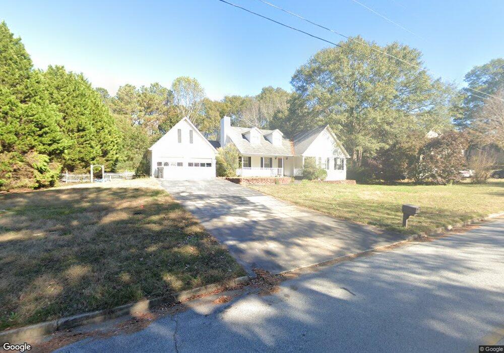
40 Windsong Dr Covington, GA 30016
Estimated Value: $271,000 - $319,000
3
Beds
2
Baths
1,964
Sq Ft
$147/Sq Ft
Est. Value
About This Home
This home is located at 40 Windsong Dr, Covington, GA 30016 and is currently estimated at $289,472, approximately $147 per square foot. 40 Windsong Dr is a home located in Newton County with nearby schools including Newton County Theme School at Ficquett, Clements Middle School, and Newton High School.
Ownership History
Date
Name
Owned For
Owner Type
Purchase Details
Closed on
Dec 6, 2017
Sold by
Deutsche Bank National Tru
Bought by
Docmars Enterprise Llc
Current Estimated Value
Purchase Details
Closed on
May 2, 2017
Sold by
Huff Donald
Bought by
Deutsche Bank National Trust C
Purchase Details
Closed on
Dec 3, 1997
Sold by
Easler Const Co Inc
Bought by
Huff Donald
Home Financials for this Owner
Home Financials are based on the most recent Mortgage that was taken out on this home.
Original Mortgage
$108,282
Interest Rate
7.26%
Mortgage Type
FHA
Create a Home Valuation Report for This Property
The Home Valuation Report is an in-depth analysis detailing your home's value as well as a comparison with similar homes in the area
Home Values in the Area
Average Home Value in this Area
Purchase History
| Date | Buyer | Sale Price | Title Company |
|---|---|---|---|
| Docmars Enterprise Llc | $100,000 | -- | |
| Deutsche Bank National Trust C | -- | -- | |
| Huff Donald | $109,900 | -- |
Source: Public Records
Mortgage History
| Date | Status | Borrower | Loan Amount |
|---|---|---|---|
| Previous Owner | Huff Donald | $108,282 |
Source: Public Records
Tax History
| Year | Tax Paid | Tax Assessment Tax Assessment Total Assessment is a certain percentage of the fair market value that is determined by local assessors to be the total taxable value of land and additions on the property. | Land | Improvement |
|---|---|---|---|---|
| 2025 | $2,975 | $118,160 | $18,000 | $100,160 |
| 2024 | $2,919 | $113,840 | $18,000 | $95,840 |
| 2023 | $3,018 | $109,960 | $7,200 | $102,760 |
| 2022 | $2,581 | $93,840 | $7,200 | $86,640 |
| 2021 | $2,045 | $66,280 | $7,200 | $59,080 |
| 2020 | $1,889 | $55,240 | $7,200 | $48,040 |
| 2019 | $1,706 | $49,040 | $7,200 | $41,840 |
| 2018 | $828 | $47,280 | $7,200 | $40,080 |
| 2017 | $1,032 | $32,960 | $6,000 | $26,960 |
| 2016 | $1,032 | $32,960 | $6,000 | $26,960 |
| 2015 | $1,084 | $34,520 | $6,000 | $28,520 |
| 2014 | $973 | $31,320 | $0 | $0 |
Source: Public Records
Map
Nearby Homes
- 90 Windsong Dr
- 35 Rolling Ridge Dr
- 50 Evelyn Rd
- 275 Hoglen Dr
- 30 Silver Peak Dr
- 40 Princeton Ct
- 65 Rosewood Cir
- 40 Bermuda Cir
- 40 Quiet Water Ct
- 115 Tanners Ct
- 365 Silver Ridge Rd
- 100 Arlington Dr Unit 2
- 200 Syracuse Ln
- 3462 Fairview Rd
- 200 Queensland Ln
- 70 Camerons Way
- 20 Fair Forest Terrace
- 105 Queensland Ln
- 40 Oak Terrace Dr
- 160 Princeton Way
- 70 Windsong Dr
- 70 Windsong Dr
- 70 Windsong Dr Unit 5
- 30 Windsong Dr
- 40 Rolling Ridge Ct
- 35 Windsong Dr
- 80 Windsong Dr
- 20 Windsong Dr
- 45 Rolling Ridge Ct
- 45 Windsong Dr
- 30 Rolling Ridge Ct
- 25 Windsong Dr
- 75 Windsong Dr
- 65 Windsong Dr
- 15 Windsong Dr
- 35 Rolling Ridge Ct
- 10 Windsong Dr
- 85 Windsong Dr
- 100 Windsong Dr
- 350 Jack Neely Rd
Your Personal Tour Guide
Ask me questions while you tour the home.