Estimated Value: $588,000 - $653,600
3
Beds
2
Baths
1,436
Sq Ft
$433/Sq Ft
Est. Value
About This Home
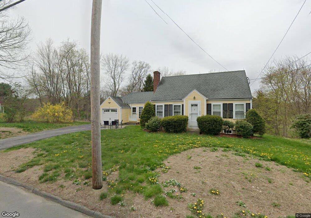
This home is located at 400 Central St, Acton, MA 01720 and is currently estimated at $621,650, approximately $432 per square foot. 400 Central St is a home located in Middlesex County with nearby schools including Acton-Boxborough Regional High School.
Ownership History
Date
Name
Owned For
Owner Type
Purchase Details
Closed on
Dec 17, 2021
Sold by
Mason Allan E Est
Bought by
Mason Glenn
Current Estimated Value
Purchase Details
Closed on
Nov 22, 1993
Sold by
Noftle John A and Noftle Randall S
Bought by
Boudreau Mark G and Boudreau Nancie J
Home Financials for this Owner
Home Financials are based on the most recent Mortgage that was taken out on this home.
Original Mortgage
$96,200
Interest Rate
6.77%
Mortgage Type
Purchase Money Mortgage
Create a Home Valuation Report for This Property
The Home Valuation Report is an in-depth analysis detailing your home's value as well as a comparison with similar homes in the area
Home Values in the Area
Average Home Value in this Area
Purchase History
| Date | Buyer | Sale Price | Title Company |
|---|---|---|---|
| Mason Glenn | -- | None Available | |
| Boudreau Mark G | $120,250 | -- |
Source: Public Records
Mortgage History
| Date | Status | Borrower | Loan Amount |
|---|---|---|---|
| Previous Owner | Boudreau Mark G | $96,200 |
Source: Public Records
Tax History Compared to Growth
Tax History
| Year | Tax Paid | Tax Assessment Tax Assessment Total Assessment is a certain percentage of the fair market value that is determined by local assessors to be the total taxable value of land and additions on the property. | Land | Improvement |
|---|---|---|---|---|
| 2025 | $9,511 | $554,600 | $272,600 | $282,000 |
| 2024 | $9,005 | $540,200 | $272,600 | $267,600 |
| 2023 | $9,050 | $515,400 | $247,800 | $267,600 |
| 2022 | $8,214 | $422,300 | $215,400 | $206,900 |
| 2021 | $7,926 | $391,800 | $199,400 | $192,400 |
| 2020 | $7,344 | $381,700 | $199,400 | $182,300 |
| 2019 | $6,967 | $359,700 | $199,400 | $160,300 |
| 2018 | $6,864 | $354,200 | $199,400 | $154,800 |
| 2017 | $6,751 | $354,200 | $199,400 | $154,800 |
| 2016 | $6,463 | $336,100 | $199,400 | $136,700 |
| 2015 | $6,403 | $336,100 | $199,400 | $136,700 |
| 2014 | $6,294 | $323,600 | $199,400 | $124,200 |
Source: Public Records
Map
Nearby Homes
- 5 Elm St Unit 1
- 4 Huron Rd
- 285 Central St Unit 285
- 116 Windsor Ave
- 92 Willow St Unit 3
- 92 Willow St Unit 2
- 90 Willow St Unit 1
- 4,7,8 Crestwood Ln
- 246 Main St Unit 2
- 4 Omega Way
- 7 Kelley Rd
- 11 Braebrook
- 33 Meadowbrook Rd
- 46 Taylor Rd
- 19 Railroad St Unit D2
- 19 Railroad St Unit C2
- 605 Stow Rd
- 131 Main St
- 129 Main St Unit 129
- 305 Harwood Ave