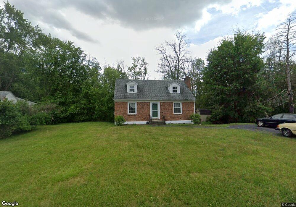
400 Consaul Rd Schenectady, NY 12304
Estimated Value: $228,457 - $313,000
2
Beds
1
Bath
850
Sq Ft
$311/Sq Ft
Est. Value
About This Home
This home is located at 400 Consaul Rd, Schenectady, NY 12304 and is currently estimated at $264,114, approximately $310 per square foot. 400 Consaul Rd is a home located in Albany County with nearby schools including Veeder Elementary School, Lisha Kill Middle School, and Colonie Central High School.
Ownership History
Date
Name
Owned For
Owner Type
Purchase Details
Closed on
May 16, 2012
Sold by
Oconnor Kevin and Oconnor Daniel
Bought by
Oconnor Kevin
Current Estimated Value
Home Financials for this Owner
Home Financials are based on the most recent Mortgage that was taken out on this home.
Original Mortgage
$132,000
Outstanding Balance
$17,903
Interest Rate
3.13%
Estimated Equity
$246,211
Purchase Details
Closed on
May 25, 2006
Sold by
Ryan James
Bought by
O'Connor Kevin
Home Financials for this Owner
Home Financials are based on the most recent Mortgage that was taken out on this home.
Original Mortgage
$166,674
Interest Rate
6.62%
Purchase Details
Closed on
Jan 3, 2006
Sold by
Besson Christopher
Bought by
Ryan James
Purchase Details
Closed on
Nov 20, 1998
Sold by
Winston Robert S
Bought by
Besson Christopher and Besson Bonnie
Purchase Details
Closed on
Mar 1, 1996
Create a Home Valuation Report for This Property
The Home Valuation Report is an in-depth analysis detailing your home's value as well as a comparison with similar homes in the area
Home Values in the Area
Average Home Value in this Area
Purchase History
| Date | Buyer | Sale Price | Title Company |
|---|---|---|---|
| Oconnor Kevin | -- | Chicago Title Insurance Co | |
| O'Connor Kevin | $168,000 | -- | |
| Oconnor Kevin | $168,000 | None Available | |
| Ryan James | $105,700 | -- | |
| Besson Christopher | $95,000 | -- | |
| -- | -- | -- |
Source: Public Records
Mortgage History
| Date | Status | Borrower | Loan Amount |
|---|---|---|---|
| Open | Oconnor Kevin | $132,000 | |
| Previous Owner | Oconnor Kevin | $166,674 |
Source: Public Records
Tax History
| Year | Tax Paid | Tax Assessment Tax Assessment Total Assessment is a certain percentage of the fair market value that is determined by local assessors to be the total taxable value of land and additions on the property. | Land | Improvement |
|---|---|---|---|---|
| 2024 | $3,869 | $79,800 | $19,900 | $59,900 |
| 2023 | $3,753 | $79,800 | $19,900 | $59,900 |
| 2022 | $3,593 | $79,800 | $19,900 | $59,900 |
| 2021 | $3,546 | $79,800 | $19,900 | $59,900 |
| 2020 | $5,314 | $79,800 | $19,900 | $59,900 |
| 2019 | $1,677 | $79,800 | $19,900 | $59,900 |
| 2018 | $3,711 | $79,800 | $19,900 | $59,900 |
| 2017 | $0 | $79,800 | $19,900 | $59,900 |
| 2016 | $2,771 | $79,800 | $19,900 | $59,900 |
| 2015 | -- | $79,800 | $19,900 | $59,900 |
| 2014 | -- | $79,800 | $19,900 | $59,900 |
Source: Public Records
Map
Nearby Homes
- 647 Pearse Rd
- 4 Kings Mill Ct
- 362 Ferris Rd
- 31 Amelia Dr
- 26 Sussex Way
- 31 Saint George Place
- 2167 Central Ave
- 4110 Consaul Rd
- 2115 Central Ave Unit 1
- 2115 Central Ave Unit 9
- 2115 Central Ave Unit 49
- 256 N Alandale Ave
- 3 Mather Ave
- 28 Fullerton Ave
- 245 N Alandale Ave
- 707 Lois Ln
- 2220 Central Ave
- 151 Fieldstone Dr
- 16 Warwick Way
- 1 Squire Rd
Your Personal Tour Guide
Ask me questions while you tour the home.