NOT LISTED FOR SALE

400 Forest Point Dr Unit 46 Brandon, MS 39047

Estimated Value: $623,845

0.73 Acre
$854,582 Price per Acre
31,799 Sq Ft Lot

Last Sold September 23, 2021

Current estimated payment $4,149/month

121 Days on Market

Highlights

  • Private Dock
  • Reservoir Front
  • Views
  • Oakdale Elementary School Rated A
  • Hiking Trails
  • Park

About This Lot

As of September 2021

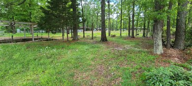
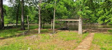
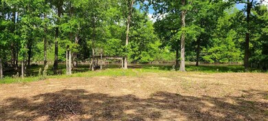
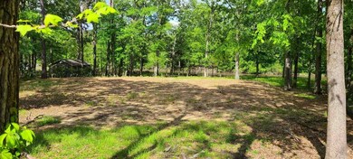
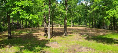
WATERFRONT LOT! Come and view this residential lot for your chance to DESIGN THAT DREAM by building your personalized home on the water at the Rez. Great location with the Reservoir walking/biking trail just down the street, a nature area-park a few doors down, multiple neighborhood parks for members of the local homeowners group, and near shopping, dining, and entertainment. Lot is level, with dirt work done, soil test in place, surveyed, with 170+ feet of waterfrontage of the Bay. Seawall and boat slip. Suburban neighborhood with appreciating housing of various ages and styles. All the Reservoir has to offer : RV, camp sights, fishing, parks, concerts, and festivals. Inquire with your REALTOR today!

Last Agent to Sell the Property

Carl Merck

Merck Team Realty, Inc. License #B13250 Listed on: 04/27/2021

Co-Listed By

Chris Merck

Merck Team Realty, Inc. License #B24103

Last Buyer's Agent

Susannah Fielder

McKee Realty, Inc. License #S40026

Property Details

Property Type

  • Land

Est. Annual Taxes

  • $1,195

Year Built

  • 2023

Lot Details

  • 0.73 Acre Lot
  • Lot Dimensions are 261.5x172.9x223.2x100
  • Reservoir Front
  • Partially Fenced Property

Schools

  • Oakdale Elementary School
  • Northwest Rankin Middle School
  • Northwest Rankin High School

Utilities

  • Phone Available
  • Cable TV Available

Additional Features

  • Property Views

Listing and Financial Details

  • Assessor Parcel Number H12C000003 00460

Community Details

Overview

  • Property has a Home Owners Association
  • Association fees include ground maintenance
  • Forest Point Subdivision

Recreation

  • Park
  • Hiking Trails
  • Bike Trail
  • Private Dock

Property Details

Property Type

Land

Est. Annual Taxes

$1,195

Year Built

2023

Lot Details

0

Listing Details

  • Lot Size: 261.5x172.9x223.2x100
  • Property Sub Type: Single Family Residence Lot
  • Prop. Type: Land
  • Road Frontage Type: County Road, Other
  • Road Surface Type: Paved
  • Lot Size Acres: 0.73
  • Co List Office Mls Id: 1527
  • Co List Office Phone: 601-919-8326
  • Subdivision Name: Forest Point
  • Directions: Spillway Road (between Grants Ferry and HughWard) to Oak Dr. Take Oak North to Forest Point Drive. Turn Right (South) and lot will be on the left on the water.
  • Special Features: None
  • Year Built (Public Record): 2023

Interior Features

  • Possible Use: Residential
  • Community Features:Other10: Yes
  • Community Features:Park: Yes
  • Community Features:HikingWalking Trails: Yes
  • Community Features:Biking Trails: Yes

Exterior Features

  • Fencing: Partial
  • Lot Features: Level, Views
  • Other Structures: Other
  • Waterfront Features: Boat Dock, Reservoir, Waterfront, Other, Walk-To
  • WaterfrontFeaturesWaterfront: Yes
  • Waterfront: Yes
  • Lot Features:Views: Yes
  • Waterfront Features:Walk-To: Yes
  • Lot Features:Level: Yes
  • Waterfront Features:Waterfront2: Yes
  • Waterfront Features:Other14: Yes
  • Waterfront Features:Boat Dock: Yes
  • Waterfront Features:Reservoir: Yes

Utilities

  • Sewer: Public Sewer
  • Utilities: Cable Available, Electricity Available, Natural Gas Available, Phone Available, Water Available, Other
  • Water Source: Public

Condo/Co-op/Association

  • Community Features: Biking Trails, Hiking/Walking Trails, Park, Other
  • Association: Yes

Association/Amenities

  • Tax and Financial Information:Association: No
  • Association Fee Includes:Maintenance Grounds: Yes

Fee Information

  • Association Fee Includes: Maintenance Grounds

Schools

  • Elementary School: Oakdale
  • High School: Northwest Rankin
  • Middle Or Junior School: Northwest Rankin Middle

Lot Info

  • Current Use: Residential, None
  • Parcel #: H12C000003 00460
  • Lot Size Sq Ft: 31798.8
  • ResoLotSizeUnits: Acres

Tax Info

  • Tax Annual Amount: 1195.0
  • Tax Year: 2020

Ownership History

Date Name Owned For Owner Type

Purchase Details

Closed on
Aug 22, 2016
Sold by
Gentry Robin
Bought by
Gentry Charles and Gentry Robin
Total Days on Market
121
Current Estimated Value
$623,845
Source: Public Records

Range of Values:

Collateral Analytics

Collateral Analytics Collateral Analytics AVMs (Automated Valuation Model) employ a number of statistical approaches combined with neighborhood-specific comparable selection guarantees the most up-to-date and precise valuations.

Not Available

Collateral Analytics does not have data for the current month. Please view the chart for historical values.

ICE

ICE Mortgage Technology ICE Mortgage Technology’s AVM (Automated Valuation Model) is a state-of-the-art online residential property valuation tool that provides a quick and accurate estimate of the value of almost any home in the U.S.

Not Available

ICE Mortgage Technology does not have data for the current month. Please view the chart for historical values.

First American

First American First American Data & Analytics’ next-generation AVM combines unrivaled data assets with a blended ensemble of valuation models to produce highly accurate, reliable valuations you can trust.

Not Available

First American does not have data for the current month. Please view the chart for historical values.

Quantarium

Quantarium Quantarium’s valuation service, repeatedly proven the industry’s most accurate and comprehensive, is supercharged with a self-learning and auto-tuning AI engine that continually becomes smarter and more accurate as it processes daily inputs from the industry’s leading RE data lake.

Not Available

Quantarium does not have data for the current month. Please view the chart for historical values.

Average Value
Not Available
List Price
Sold Price
Create a Home Valuation Report for This Property
The Home Valuation Report is an in-depth analysis detailing your home's value as well as a comparison with similar homes in the area

Home Values in the Area

Source: Public Records

Average Home Value in this Area


Source: Public Records

Purchase History

Date Buyer Sale Price Title Company
Gentry Charles -- None Available
Source: Public Records

Property History

Date Event Price Change Sq Ft Price
09/23/2021 09/23/21 Sold -- -- --
08/26/2021 08/26/21 Pending -- -- --
04/26/2021 04/26/21 For Sale $154,900 -- --
Source: MLS United

Tax History Compared to Growth

Source: Public Records

Tax History

Year Tax Paid Tax Assessment Tax Assessment Total Assessment is a certain percentage of the fair market value that is determined by local assessors to be the total taxable value of land and additions on the property. Land Improvement
2024 $7,769 $74,925 $0 $0
2023 $1,212 $11,250 $0 $0
2022 $1,195 $11,250 $0 $0
2021 $1,195 $11,250 $0 $0
2020 $1,195 $11,250 $0 $0
2019 $1,226 $11,250 $0 $0
2018 $1,203 $11,250 $0 $0
2017 $2,306 $21,558 $0 $0
2016 $2,978 $21,705 $0 $0
2015 $711 $14,470 $0 $0
2014 $696 $14,470 $0 $0
2013 -- $14,470 $0 $0
Source: Public Records

Agents Affiliated with this Home

  • Section Image
  • Section Image
  • Section Image
See All Agents

Map

Source: MLS United

MLS Number: 1339982

MLS United

APN: H12C-000003-00460