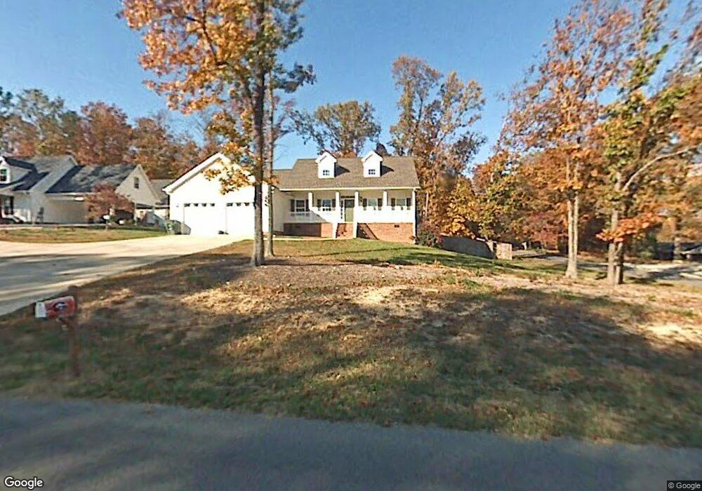
400 Forrest Park Rd Dalton, GA 30721
Estimated Value: $334,000 - $383,000
Studio
3
Baths
2,694
Sq Ft
$132/Sq Ft
Est. Value
About This Home
This home is located at 400 Forrest Park Rd, Dalton, GA 30721 and is currently estimated at $356,735, approximately $132 per square foot. 400 Forrest Park Rd is a home located in Whitfield County with nearby schools including Pleasant Grove Elementary School, New Hope Middle School, and Northwest Whitfield County High School.
Ownership History
Date
Name
Owned For
Owner Type
Purchase Details
Closed on
Jul 12, 2005
Sold by
Not Provided
Bought by
Redmond David Andrew and Redmond Lisa Treadwell
Current Estimated Value
Purchase Details
Closed on
Aug 2, 2004
Sold by
Rogers Randy
Bought by
Redmond David and Redmond Lisa
Purchase Details
Closed on
Jan 15, 2004
Sold by
Mcmillan Larry and Sylvia Jean
Bought by
Rogers Randy
Purchase Details
Closed on
Jan 22, 2003
Sold by
Berry April H
Bought by
Mcmillan Larry and Sylvia Jean
Purchase Details
Closed on
Apr 1, 1999
Bought by
Berry April H
Create a Home Valuation Report for This Property
The Home Valuation Report is an in-depth analysis detailing your home's value as well as a comparison with similar homes in the area
Purchase History
| Date | Buyer | Sale Price | Title Company |
|---|---|---|---|
| Redmond David Andrew | -- | -- | |
| Redmond David | $230,000 | -- | |
| Rogers Randy | $31,000 | -- | |
| Mcmillan Larry | $29,000 | -- | |
| Berry April H | $22,000 | -- |
Source: Public Records
Tax History
| Year | Tax Paid | Tax Assessment Tax Assessment Total Assessment is a certain percentage of the fair market value that is determined by local assessors to be the total taxable value of land and additions on the property. | Land | Improvement |
|---|---|---|---|---|
| 2025 | $3,481 | $159,478 | $15,600 | $143,878 |
| 2024 | $3,481 | $159,478 | $15,600 | $143,878 |
| 2023 | $3,459 | $115,647 | $10,600 | $105,047 |
| 2022 | $2,625 | $89,017 | $10,600 | $78,417 |
| 2021 | $2,627 | $89,017 | $10,600 | $78,417 |
| 2020 | $2,716 | $89,017 | $10,600 | $78,417 |
| 2019 | $2,760 | $89,017 | $10,600 | $78,417 |
| 2018 | $2,569 | $81,548 | $10,600 | $70,948 |
| 2017 | $2,571 | $81,548 | $10,600 | $70,948 |
| 2016 | $2,441 | $80,524 | $12,600 | $67,924 |
| 2014 | $2,167 | $80,524 | $12,600 | $67,924 |
| 2013 | -- | $85,107 | $12,600 | $72,507 |
Source: Public Records
Map
Nearby Homes
- 522 Westbrook Rd
- 507 Riderwood Dr
- 4046 Sydney Cir
- 503 Moore Dr
- 302 Ricky Dr
- 397 Woodlawn Ave
- 2502 E Hillview Dr
- 1903 Summit View Dr Unit 188
- 1903 Middle Summit Dr
- 629 Mahogany Ln NW
- 649 Neely Rd NW
- 2609 E Hillview Dr
- 1896 Summit House Dr Unit 239
- 1709 Willow Oak Ln Unit 53
- 1706 Chestnut Oak Dr Unit 91
- 1702 Chestnut Oak Dr Unit 81
- 1702 Chestnut Oak Dr Unit 83
- 1702 Chestnut Oak Dr
- 627 Fox Den Cir
- 621 Fox Den Cir
- 00 Greenleaf Cir
- 402 Forrest Park Rd
- 402 Forrest Park Rd
- 75 Green Leaf Cir
- 306 Forrest Park Rd
- 107 Green Leaf Cir
- 404 Forrest Park Rd
- 401 Forrest Park Rd
- 309 Forrest Park Rd
- 309 Forrest Park Rd
- 100 Greenleaf Cir
- 402 Forest Park Rd
- 0 Greenleaf Cir Unit RTC2721569
- 0 Greenleaf Cir Unit 116546
- 0 Greenleaf Cir Unit RTC2335434
- 100 Green Leaf Cir
- 304 Forrest Park Rd
- 403 Forrest Park Rd
- 305 Forrest Park Rd
- 109 Green Leaf Cir
Your Personal Tour Guide
Ask me questions while you tour the home.