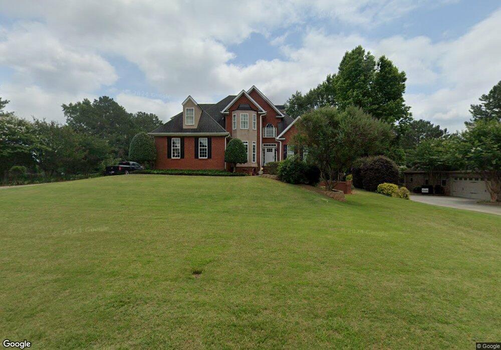
400 Mcgarity Dr McDonough, GA 30252
Estimated Value: $464,000 - $532,000
5
Beds
4
Baths
2,656
Sq Ft
$186/Sq Ft
Est. Value
About This Home
This home is located at 400 Mcgarity Dr, McDonough, GA 30252 and is currently estimated at $493,017, approximately $185 per square foot. 400 Mcgarity Dr is a home located in Henry County with nearby schools including Ola Elementary School, Ola Middle School, and Ola High School.
Ownership History
Date
Name
Owned For
Owner Type
Purchase Details
Closed on
May 19, 2006
Sold by
Eaves Creed W
Bought by
Collier Christopher S and Collier Christina T
Current Estimated Value
Home Financials for this Owner
Home Financials are based on the most recent Mortgage that was taken out on this home.
Original Mortgage
$254,615
Outstanding Balance
$148,304
Interest Rate
6.5%
Mortgage Type
New Conventional
Estimated Equity
$344,713
Purchase Details
Closed on
Jan 29, 1998
Sold by
Evergreen Homes Inc
Bought by
Eaves Creed William
Home Financials for this Owner
Home Financials are based on the most recent Mortgage that was taken out on this home.
Original Mortgage
$190,000
Interest Rate
7.07%
Mortgage Type
New Conventional
Create a Home Valuation Report for This Property
The Home Valuation Report is an in-depth analysis detailing your home's value as well as a comparison with similar homes in the area
Home Values in the Area
Average Home Value in this Area
Purchase History
| Date | Buyer | Sale Price | Title Company |
|---|---|---|---|
| Collier Christopher S | $279,900 | -- | |
| Eaves Creed William | $237,500 | -- |
Source: Public Records
Mortgage History
| Date | Status | Borrower | Loan Amount |
|---|---|---|---|
| Open | Collier Christopher S | $254,615 | |
| Previous Owner | Eaves Creed William | $190,000 |
Source: Public Records
Tax History Compared to Growth
Tax History
| Year | Tax Paid | Tax Assessment Tax Assessment Total Assessment is a certain percentage of the fair market value that is determined by local assessors to be the total taxable value of land and additions on the property. | Land | Improvement |
|---|---|---|---|---|
| 2025 | $5,884 | $193,080 | $25,000 | $168,080 |
| 2024 | $5,884 | $192,040 | $25,000 | $167,040 |
| 2023 | $5,339 | $188,240 | $23,520 | $164,720 |
| 2022 | $5,239 | $162,640 | $23,520 | $139,120 |
| 2021 | $4,601 | $135,640 | $22,520 | $113,120 |
| 2020 | $4,439 | $128,760 | $20,000 | $108,760 |
| 2019 | $4,339 | $124,560 | $20,000 | $104,560 |
| 2018 | $4,170 | $117,400 | $18,400 | $99,000 |
| 2016 | $3,630 | $99,520 | $19,200 | $80,320 |
| 2015 | $3,456 | $92,560 | $19,200 | $73,360 |
| 2014 | $3,240 | $86,240 | $16,600 | $69,640 |
Source: Public Records
Map
Nearby Homes
- 804 Eggie Ct
- 2400 Honey Ct
- 2407 Honey Ct
- 702 Euel Dr
- 240 Huiet Dr Unit 8
- 0 Huiet Unit 10486750
- 0 Huiet Unit 7546040
- 723 Euel Dr Unit 6
- 550 Mcgarity Dr Unit 6
- 660 Milton Dr
- 1006 Tez Ct
- 2110 Mcgarity Rd
- 1705 Lake Dow Rd
- 721 Milton Dr
- 105 Berry Ct
- 1170 Upchurch Rd
- 1120 Upchurch Rd Unit 3
- 1535 Lake Dow Rd
- 1330 Upchurch Rd
- 140 Wilson Dr
- 0 Mcgarity Dr Unit 2656402
- 0 Mcgarity Dr Unit 7052990
- 0 Mcgarity Dr Unit 7141643
- 0 Mcgarity Dr Unit 5111227
- 0 Mcgarity Dr Unit 8709361
- 0 Mcgarity Dr Unit 3220357
- 0 Mcgarity Dr Unit 8712672
- 0 Mcgarity Dr Unit 8970720
- 0 Mcgarity Dr Unit 8723219
- 0 Mcgarity Dr Unit 9040768
- 0 Mcgarity Dr Unit 9074397
- 0 Mcgarity Dr Unit 8789604
- 0 Mcgarity Dr Unit 8805528
- 0 Mcgarity Dr Unit 8830905
- 0 Mcgarity Dr Unit 2864555
- 0 Mcgarity Dr Unit 7207811
- 0 Mcgarity Dr Unit 7213458
- 0 Mcgarity Dr Unit 7220785
- 0 Mcgarity Dr Unit 7238724
- 0 Mcgarity Dr Unit 7267773