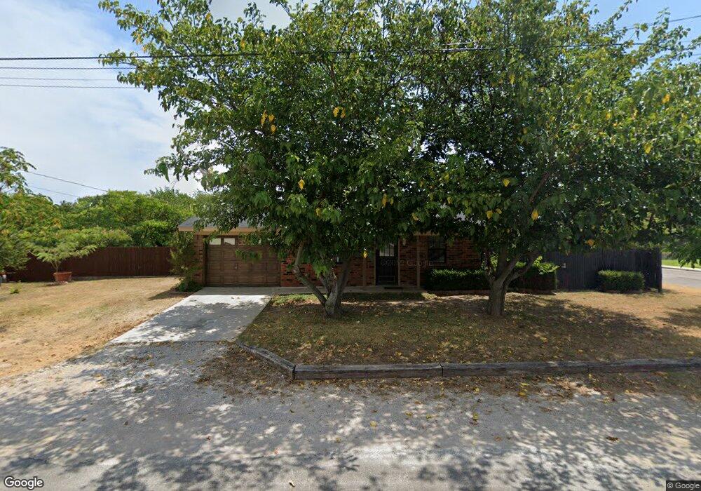
400 N Trenchard St Decatur, TX 76234
Estimated Value: $206,614 - $252,000
--
Bed
--
Bath
1,064
Sq Ft
$208/Sq Ft
Est. Value
About This Home
This home is located at 400 N Trenchard St, Decatur, TX 76234 and is currently estimated at $221,404, approximately $208 per square foot. 400 N Trenchard St is a home located in Wise County with nearby schools including Decatur High School and Victory Christian Academy.
Ownership History
Date
Name
Owned For
Owner Type
Purchase Details
Closed on
Sep 26, 2020
Sold by
Inguanzo David and Inguanzo Maria
Bought by
Inguanzo Juan C and Guadiana Karina V
Current Estimated Value
Purchase Details
Closed on
Oct 28, 2010
Sold by
Bale Britney L
Bought by
Inguanzo David and Inguanzo Maria Amelia
Purchase Details
Closed on
Oct 2, 2003
Sold by
Messenger William C-Stoff
Bought by
Inguanzo David and Inguanzo Maria
Create a Home Valuation Report for This Property
The Home Valuation Report is an in-depth analysis detailing your home's value as well as a comparison with similar homes in the area
Home Values in the Area
Average Home Value in this Area
Purchase History
| Date | Buyer | Sale Price | Title Company |
|---|---|---|---|
| Inguanzo Juan C | -- | None Available | |
| Inguanzo David | -- | -- | |
| Inguanzo David | -- | -- |
Source: Public Records
Tax History Compared to Growth
Tax History
| Year | Tax Paid | Tax Assessment Tax Assessment Total Assessment is a certain percentage of the fair market value that is determined by local assessors to be the total taxable value of land and additions on the property. | Land | Improvement |
|---|---|---|---|---|
| 2025 | $2,081 | $186,020 | -- | -- |
| 2024 | $2,081 | $169,109 | $0 | $0 |
| 2023 | $3,532 | $194,730 | $51,750 | $142,980 |
| 2022 | $3,203 | $146,261 | $34,500 | $111,761 |
| 2021 | $2,899 | $127,050 | $34,500 | $92,550 |
| 2020 | $2,843 | $121,200 | $32,340 | $88,860 |
| 2019 | $2,885 | $116,400 | $32,340 | $84,060 |
| 2018 | $2,692 | $104,100 | $12,940 | $91,160 |
| 2017 | $2,121 | $81,730 | $10,780 | $70,950 |
| 2016 | $2,124 | $81,830 | $10,780 | $71,050 |
| 2015 | -- | $72,760 | $10,780 | $61,980 |
| 2014 | -- | $71,350 | $8,630 | $62,720 |
Source: Public Records
Map
Nearby Homes
- 407 N Lane St
- 0 N Hwy 287 Unit 25379920
- 606 W Mulberry St
- 601 W Brady St
- 1 S Martin Extension
- 401 S Holman St
- 304 Cyndilu Ln
- 101 E Mulberry St
- 700 N Church St
- 802 N Church St
- 305 E Shoemaker St
- 204 W Collins St
- TBD Farm To Market 51
- 903 N Miller St
- 602 N Cates St
- 709 S Church St
- W W Rose Ave
- 4112 U S 380
- 50+/- acres U S 380
- 114 Sondra Lin Blvd