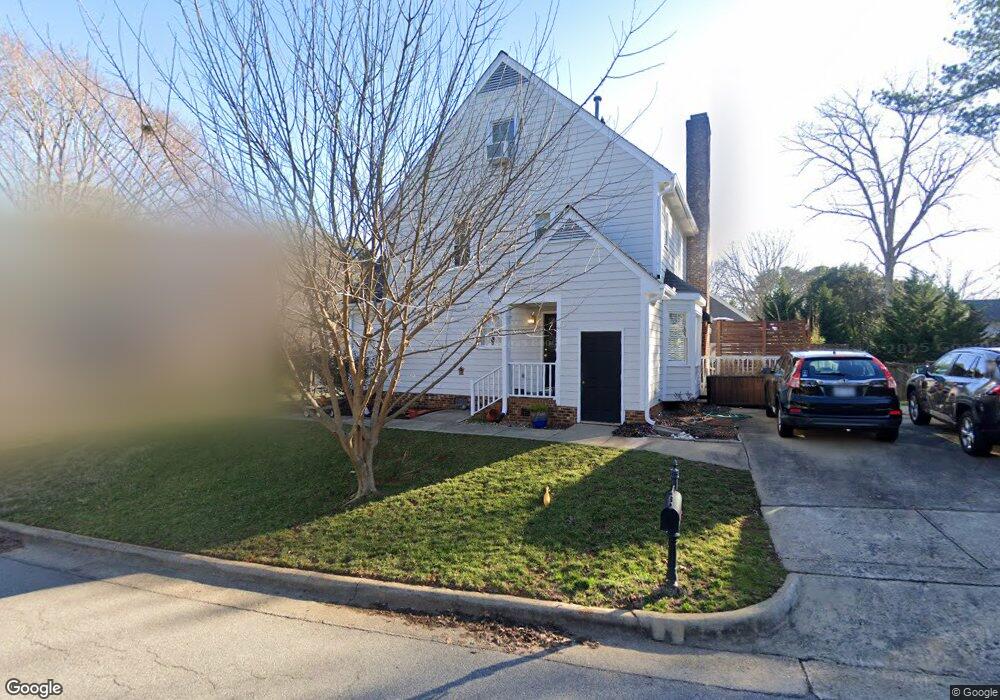
400 Robb Ct Raleigh, NC 27615
North Hills NeighborhoodEstimated Value: $454,000 - $575,000
About This Home
This home is located at 400 Robb Ct, Raleigh, NC 27615 and is currently estimated at $526,521, approximately $240 per square foot. 400 Robb Ct is a home located in Wake County with nearby schools including North Ridge Elementary School, West Millbrook Middle School, and Sanderson High School.
Ownership History
We collect this data history from publicly available records. To have your information removed, we recommend requesting removal directly through your county’s website.
Purchase Details
Purchase Details
Home Financials for this Owner
Home Financials are based on the most recent Mortgage that was taken out on this home.Home Values in the Area
Average Home Value in this Area
Purchase History
We collect this data history from publicly available records. To have your information removed, we recommend requesting removal directly through your county’s website.
| Date | Buyer | Sale Price | Title Company |
|---|---|---|---|
| -- | None Listed On Document | ||
| $303,500 | None Available |
Mortgage History
We collect this data history from publicly available records. To have your information removed, we recommend requesting removal directly through your county’s website.
| Date | Status | Borrower | Loan Amount |
|---|---|---|---|
| Previous Owner | $242,800 |
Tax History
We collect this data history from publicly available records. To have your information removed, we recommend requesting removal directly through your county’s website.
| Year | Tax Paid | Tax Assessment Tax Assessment Total Assessment is a certain percentage of the fair market value that is determined by local assessors to be the total taxable value of land and additions on the property. | Land | Improvement |
|---|---|---|---|---|
| 2025 | $4,324 | $493,538 | $125,000 | $368,538 |
| 2024 | $4,306 | $493,538 | $125,000 | $368,538 |
| 2023 | $3,665 | $334,371 | $98,000 | $236,371 |
| 2022 | $3,406 | $334,371 | $98,000 | $236,371 |
| 2021 | $3,273 | $334,371 | $98,000 | $236,371 |
| 2020 | $3,214 | $334,371 | $98,000 | $236,371 |
| 2019 | $3,176 | $272,331 | $100,000 | $172,331 |
| 2018 | $2,995 | $272,331 | $100,000 | $172,331 |
| 2017 | $2,853 | $266,115 | $100,000 | $166,115 |
| 2016 | $2,598 | $253,064 | $100,000 | $153,064 |
| 2015 | $2,490 | $238,561 | $84,000 | $154,561 |
| 2014 | $2,362 | $238,561 | $84,000 | $154,561 |
Map
- 405 Lynchester Ct
- 412 Thyme Place
- 300 Ashebrook Dr
- 6709 van Haven Dr
- 252 Ashton Hall Ln
- 7010 Sandy Forks Rd Unit 106
- 6625 Suburban Dr
- 6103 Tipping Cir
- 6012 Tenter Banks Square
- 803 The Village Cir
- 5867 Branchwood Rd
- 200 Northclift Dr
- 5918 Windham Dr
- 6001 Applewood Ln
- 221 Dublin Rd
- 6523 New Market Way Unit 6523
- 5904 Applewood Ln
- 6423 New Market Way Unit 6423
- 6561 New Market Way Unit 6561
- 5813 Branchwood Rd
- 404 Robb Ct
- 408 Maylands Ave
- 408 Robb Ct
- 421 Maylands Ave
- 425 Maylands Ave
- 417 Maylands Ave
- 429 Maylands Ave
- 409 Robb Ct
- 404 Maylands Ave
- 401 Robb Ct
- 413 Maylands Ave
- 6605 Portsmouth Ln
- 501 Maylands Ave
- 405 Robb Ct
- 6601 Portsmouth Ln
- 509 Sierra Vista Way
- 505 Sierra Vista Way
- 504 Sierra Vista Way
- 6609 Portsmouth Ln
- 505 Maylands Ave
Ask me questions while you tour the home.