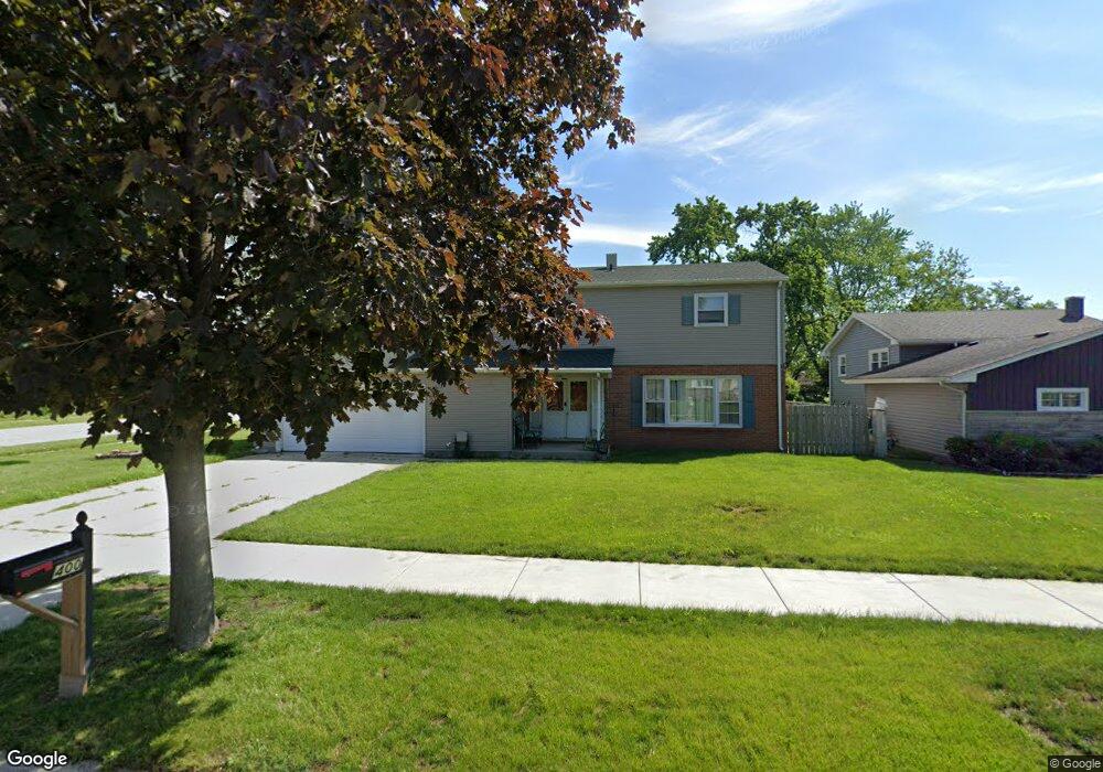
400 Sherwood Dr Crown Point, IN 46307
Estimated Value: $302,762 - $351,000
5
Beds
2
Baths
1,940
Sq Ft
$169/Sq Ft
Est. Value
About This Home
This home is located at 400 Sherwood Dr, Crown Point, IN 46307 and is currently estimated at $326,941, approximately $168 per square foot. 400 Sherwood Dr is a home located in Lake County with nearby schools including Dwight D. Eisenhower Elementary School, Robert Taft Middle School, and Crown Point High School.
Ownership History
Date
Name
Owned For
Owner Type
Purchase Details
Closed on
Mar 26, 2025
Sold by
Susanne Marie Living Trust and Neal Susanne Marie
Bought by
Neal Susanne M
Current Estimated Value
Purchase Details
Closed on
Apr 30, 2018
Sold by
Neal Susanne M
Bought by
The Susanne Marie Neal Living Trust
Purchase Details
Closed on
Jul 28, 2016
Sold by
Antal George W and Antal Margaret S
Bought by
Neal Susanne M and Barton Theresa M
Purchase Details
Closed on
Jun 11, 2012
Sold by
Antal George W and Antal Margaret S
Bought by
Neal Susanne M and Barton Theresa M
Create a Home Valuation Report for This Property
The Home Valuation Report is an in-depth analysis detailing your home's value as well as a comparison with similar homes in the area
Home Values in the Area
Average Home Value in this Area
Purchase History
| Date | Buyer | Sale Price | Title Company |
|---|---|---|---|
| Neal Susanne M | -- | None Listed On Document | |
| The Susanne Marie Neal Living Trust | -- | None Available | |
| Neal Susanne M | -- | None Available | |
| Neal Susanne M | -- | None Available |
Source: Public Records
Tax History Compared to Growth
Tax History
| Year | Tax Paid | Tax Assessment Tax Assessment Total Assessment is a certain percentage of the fair market value that is determined by local assessors to be the total taxable value of land and additions on the property. | Land | Improvement |
|---|---|---|---|---|
| 2024 | $2,178 | $243,900 | $40,500 | $203,400 |
| 2023 | $2,292 | $221,000 | $40,500 | $180,500 |
| 2022 | $2,292 | $215,800 | $40,500 | $175,300 |
| 2021 | $1,978 | $200,300 | $27,200 | $173,100 |
| 2020 | $2,020 | $197,900 | $27,200 | $170,700 |
| 2019 | $1,935 | $188,500 | $27,200 | $161,300 |
| 2018 | $1,931 | $182,200 | $27,200 | $155,000 |
| 2017 | $1,886 | $178,100 | $27,200 | $150,900 |
| 2016 | $1,886 | $176,200 | $27,200 | $149,000 |
| 2014 | $1,645 | $170,200 | $27,200 | $143,000 |
| 2013 | $1,717 | $173,400 | $27,200 | $146,200 |
Source: Public Records
Map
Nearby Homes
- 300 Omega Dr
- 425 Sherwood Dr
- 1152 S Ridge St
- 642 Omega Dr
- 924 W Crestview Ct
- 217 Crestview Ln
- 801 Courtney Dr
- 780 Williams Ct
- 1002 Gordon Ct
- 244 Sawgrass Dr
- 246 Sawgrass Dr
- 248 Sawgrass Dr
- 991 Greenview Dr
- 744 S Court St
- The Ganby Plan at Sawgrass
- The Monarch Plan at Sawgrass
- The Keystone Plan at Sawgrass
- The Breckenridge Plan at Sawgrass
- 2439 W 127th Ave
- 11498 Hancock Dr
- 410 Sherwood Dr
- 1204 Pettibone St
- 320 Sherwood Dr
- 416 Sherwood Dr
- 323 Sherwood Dr
- 401 Sherwood Dr
- 1231 Maxwell St
- 1221 Maxwell St
- 319 Sherwood Dr
- 413 Sherwood Dr
- 311 Las Olas Dr
- 403 Las Olas Dr
- 422 Sherwood Dr
- 314 Sherwood Dr
- 1211 Maxwell St
- 315 Sherwood Dr
- 417 Sherwood Dr
- 307 Las Olas Dr
- 419 Las Olas Dr
- 310 Magnolia Dr