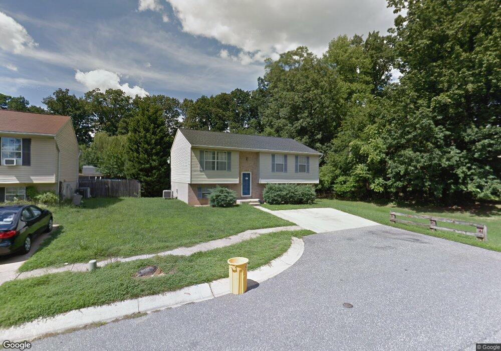
400 Strathspey Rd Glen Burnie, MD 21061
Estimated Value: $348,021 - $469,000
--
Bed
2
Baths
1,188
Sq Ft
$343/Sq Ft
Est. Value
About This Home
This home is located at 400 Strathspey Rd, Glen Burnie, MD 21061 and is currently estimated at $408,005, approximately $343 per square foot. 400 Strathspey Rd is a home located in Anne Arundel County with nearby schools including George T. Cromwell Elementary School, Lindale Middle School, and North County High School.
Ownership History
Date
Name
Owned For
Owner Type
Purchase Details
Closed on
Jun 29, 1998
Sold by
Henson Robert L
Bought by
Henson Robert L and Henson Gail D
Current Estimated Value
Purchase Details
Closed on
Oct 5, 1992
Sold by
Inverness Woods Dev Corp
Bought by
Henson Robert L
Home Financials for this Owner
Home Financials are based on the most recent Mortgage that was taken out on this home.
Original Mortgage
$127,200
Interest Rate
7.93%
Purchase Details
Closed on
Jun 30, 1992
Sold by
Brooks Et Al Ella I
Bought by
Inverness Woods Dev Corp
Create a Home Valuation Report for This Property
The Home Valuation Report is an in-depth analysis detailing your home's value as well as a comparison with similar homes in the area
Home Values in the Area
Average Home Value in this Area
Purchase History
| Date | Buyer | Sale Price | Title Company |
|---|---|---|---|
| Henson Robert L | -- | -- | |
| Henson Robert L | $133,900 | -- | |
| Inverness Woods Dev Corp | $400,000 | -- |
Source: Public Records
Mortgage History
| Date | Status | Borrower | Loan Amount |
|---|---|---|---|
| Previous Owner | Henson Robert L | $127,200 |
Source: Public Records
Tax History Compared to Growth
Tax History
| Year | Tax Paid | Tax Assessment Tax Assessment Total Assessment is a certain percentage of the fair market value that is determined by local assessors to be the total taxable value of land and additions on the property. | Land | Improvement |
|---|---|---|---|---|
| 2025 | $3,038 | $359,800 | $161,100 | $198,700 |
| 2024 | $3,038 | $335,033 | $0 | $0 |
| 2023 | $2,933 | $310,267 | $0 | $0 |
| 2022 | $2,721 | $285,500 | $128,600 | $156,900 |
| 2021 | $5,356 | $282,100 | $0 | $0 |
| 2020 | $2,596 | $278,700 | $0 | $0 |
| 2019 | $2,557 | $275,300 | $94,900 | $180,400 |
| 2018 | $2,792 | $275,300 | $94,900 | $180,400 |
| 2017 | $2,426 | $275,300 | $0 | $0 |
| 2016 | -- | $280,300 | $0 | $0 |
| 2015 | -- | $259,033 | $0 | $0 |
| 2014 | -- | $237,767 | $0 | $0 |
Source: Public Records
Map
Nearby Homes
- 1611 Tieman Dr
- 1603 Sunshine St
- 1614 Tieman Dr
- 904 Pleasantville Dr
- 1509 Baby Baer Ct
- 1515 Baby Baer Ct
- 307 Shipley Ave
- 114 Wellham Ave NW
- 30 W Furnace Branch Rd
- 103 Janelin Dr
- 607 Wellham Ave
- 103 Vista Ave
- 2 Woods Ave
- 898 Brighton Place
- 613 Wellham Ave
- 6420 Jefferson Place
- 114 Olen Dr
- 6516 Jefferson Place
- 7231 Baltimore Annapolis Blvd
- 7121 Baltimore Annapolis Blvd
- 402 Strathspey Rd
- 1523 Lochaber Ct
- 1519 Lochaber Ct
- 1521 Lochaber Ct
- 1517 Lochaber Ct
- 401 Strathspey Rd
- 1540 Brookhill Terrace
- 1525 Lochaber Ct
- 403 Strathspey Rd
- 1527 Lochaber Ct
- 319 Ryan Rd
- 1513 Lochaber Ct
- 321 Ryan Rd
- 1541 Brookhill Terrace
- 1509 Lochaber Ct
- 1518 Lochaber Ct
- 1516 Lochaber Ct
- 317 Ryan Rd
- 1528 Lochaber Ct
- 1511 Lochaber Ct