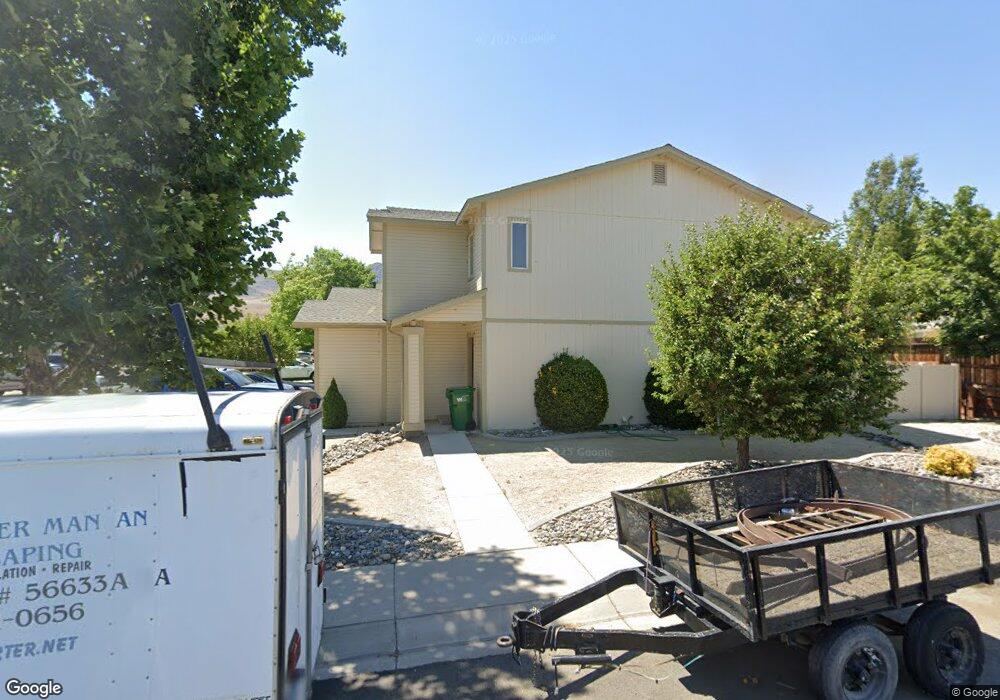
400 Valley Cir Dayton, NV 89403
Estimated Value: $453,949 - $566,000
6
Beds
4
Baths
2,474
Sq Ft
$206/Sq Ft
Est. Value
About This Home
This home is located at 400 Valley Cir, Dayton, NV 89403 and is currently estimated at $510,737, approximately $206 per square foot. 400 Valley Cir is a home located in Lyon County with nearby schools including Sutro Elementary School, Dayton Intermediate School, and Dayton High School.
Ownership History
Date
Name
Owned For
Owner Type
Purchase Details
Closed on
Jan 24, 2011
Sold by
Pilkinton John L
Bought by
Pilkinton John L and The John L Pilkinton Living Trust
Current Estimated Value
Home Financials for this Owner
Home Financials are based on the most recent Mortgage that was taken out on this home.
Original Mortgage
$129,125
Outstanding Balance
$88,075
Interest Rate
4.79%
Mortgage Type
VA
Estimated Equity
$422,662
Create a Home Valuation Report for This Property
The Home Valuation Report is an in-depth analysis detailing your home's value as well as a comparison with similar homes in the area
Home Values in the Area
Average Home Value in this Area
Purchase History
| Date | Buyer | Sale Price | Title Company |
|---|---|---|---|
| Pilkinton John L | -- | Northern Nevada Title Co | |
| Pilkinton John L | $125,000 | Northern Nevada Title Co |
Source: Public Records
Mortgage History
| Date | Status | Borrower | Loan Amount |
|---|---|---|---|
| Open | Pilkinton John L | $129,125 |
Source: Public Records
Tax History Compared to Growth
Tax History
| Year | Tax Paid | Tax Assessment Tax Assessment Total Assessment is a certain percentage of the fair market value that is determined by local assessors to be the total taxable value of land and additions on the property. | Land | Improvement |
|---|---|---|---|---|
| 2025 | $2,383 | $105,534 | $36,628 | $68,907 |
| 2024 | $2,206 | $107,896 | $36,627 | $71,268 |
| 2023 | $2,206 | $98,858 | $36,628 | $62,230 |
| 2022 | $1,763 | $94,856 | $36,628 | $58,228 |
| 2021 | $1,633 | $93,885 | $36,628 | $57,257 |
| 2020 | $1,511 | $97,907 | $36,630 | $61,277 |
| 2019 | $1,416 | $96,171 | $36,630 | $59,541 |
| 2018 | $1,375 | $86,288 | $28,180 | $58,108 |
| 2017 | $1,335 | $82,169 | $24,500 | $57,669 |
| 2016 | $1,301 | $46,526 | $10,630 | $35,896 |
| 2015 | $1,298 | $42,987 | $10,630 | $32,357 |
| 2014 | -- | $39,487 | $10,640 | $28,847 |
Source: Public Records
Map
Nearby Homes
- 628 Rock Island Dr
- 463 Sheep Camp Dr
- 300 Golden Pick Dr
- 467 Sheep Camp Dr
- 469 Sheep Camp Dr
- 471 Sheep Camp Dr Unit Lot 139
- 470 Sheep Camp Dr
- 473 Sheep Camp Dr Unit Lot 140
- 298 Monte Cristo Dr
- 475 Sheep Camp Dr
- 475 Sheep Camp Dr Unit Lot 141
- 618 Union Rd
- 618 Union Rd Unit Lot 67
- 201 Crown Point Dr
- 502 Russell Rd
- 502 Russell Rd Unit Lot 93
- WASHOE Plan at Amber Ridge
- YOSEMITE Plan at Amber Ridge
- TAHOE Plan at Amber Ridge
- TOPAZ Plan at Amber Ridge
- 400 Valley Cir Unit A
- 400 Valley Cir Unit B
- 402 Valley Cir
- 101 Southend Dr
- 103 Southend Dr
- 139 Dayton Village Pkwy
- 404 Valley Cir
- 105 Southend Dr
- 340 Sweetwater Cir Unit A B C D
- 500 Northgate Dr
- 403 Valley Cir
- 107 Southend Dr
- 343 Sweetwater Cir Unit A B C D
- 102 Southend Dr
- 104 Southend Dr
- 406 Valley Cir
- 136 Dayton Village Pkwy
- 502 Northgate Dr
- 109 Southend Dr
- 336 Sweetwater Cir