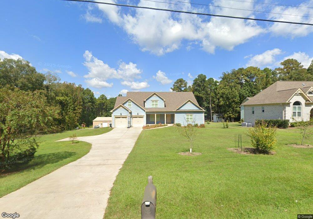
4001 Laurel Dr Durham, NC 27703
Bethesda NeighborhoodEstimated Value: $844,000 - $1,217,649
6
Beds
6
Baths
4,424
Sq Ft
$232/Sq Ft
Est. Value
About This Home
This home is located at 4001 Laurel Dr, Durham, NC 27703 and is currently estimated at $1,024,662, approximately $231 per square foot. 4001 Laurel Dr is a home located in Durham County with nearby schools including Bethesda Elementary School, John W Neal Middle School, and Southern School of Energy & Sustainability.
Ownership History
Date
Name
Owned For
Owner Type
Purchase Details
Closed on
May 21, 2015
Sold by
Jackson Pedro and Jackson Laurie Clay
Bought by
Jackson Pedro and Jackson Laurie Clay
Current Estimated Value
Home Financials for this Owner
Home Financials are based on the most recent Mortgage that was taken out on this home.
Original Mortgage
$349,000
Outstanding Balance
$269,538
Interest Rate
3.75%
Mortgage Type
Construction
Estimated Equity
$755,124
Purchase Details
Closed on
Jul 7, 2014
Sold by
Ferguson Donald M and Ferguson Anne D
Bought by
Jackson Pedro and Clay Laurie
Create a Home Valuation Report for This Property
The Home Valuation Report is an in-depth analysis detailing your home's value as well as a comparison with similar homes in the area
Home Values in the Area
Average Home Value in this Area
Purchase History
| Date | Buyer | Sale Price | Title Company |
|---|---|---|---|
| Jackson Pedro | -- | Attorney | |
| Jackson Pedro | $39,000 | None Available |
Source: Public Records
Mortgage History
| Date | Status | Borrower | Loan Amount |
|---|---|---|---|
| Open | Jackson Pedro | $349,000 |
Source: Public Records
Tax History
| Year | Tax Paid | Tax Assessment Tax Assessment Total Assessment is a certain percentage of the fair market value that is determined by local assessors to be the total taxable value of land and additions on the property. | Land | Improvement |
|---|---|---|---|---|
| 2025 | $8,020 | $1,200,292 | $223,720 | $976,572 |
| 2024 | $5,601 | $567,702 | $69,355 | $498,347 |
| 2023 | $5,390 | $567,702 | $69,355 | $498,347 |
| 2022 | $5,240 | $567,702 | $69,355 | $498,347 |
| 2021 | $4,979 | $567,702 | $69,355 | $498,347 |
| 2020 | $4,866 | $567,702 | $69,355 | $498,347 |
| 2019 | $4,809 | $567,702 | $69,355 | $498,347 |
| 2018 | $4,666 | $505,533 | $30,443 | $475,090 |
| 2017 | $4,320 | $483,706 | $30,431 | $453,275 |
| 2016 | $263 | $30,431 | $30,431 | $0 |
| 2015 | $475 | $36,399 | $36,399 | $0 |
| 2014 | $477 | $36,399 | $36,399 | $0 |
Source: Public Records
Map
Nearby Homes
- 2159 Mica Ridge Ln
- 2157 Mica Ridge Ln
- 2203 Mica Ridge Ln
- 3311 Gypsum Dr
- 3301 Gypsum Dr
- 3215 Opal Dr
- 3217 Gypsum Dr
- 3215 Gypsum Dr
- 3303 Gypsum Dr
- 3213 Gypsum Dr
- 3211 Gypsum Dr
- 3309 Gypsum Dr
- 3207 Gypsum Dr
- 3205 Gypsum Dr
- 3302 Gypsum Dr
- 3224 Gypsum Dr
- 3226 Gypsum Dr
- 3222 Gypsum Dr
- 3218 Gypsum Dr
- 3216 Gypsum Dr
- 4001 Laurel Dr Unit 6
- 4007 Laurel Dr
- 4007 Laurel Dr Unit 5
- 3901 Laurel Dr
- 3946 Laurel Dr
- 4009 Laurel Dr
- 4000 Laurel Dr
- 3903 Laurel Dr
- 4008 Laurel Dr
- 4017 Laurel Dr
- 4012 Laurel Dr
- 1308 Bungalow Ave
- 1313 Bungalow Ave
- 1309 Audrey Dr
- 1315 Bungalow Ave
- 1312 Bungalow Ave
- 1311 Audrey Dr
- 1313 Audrey Dr
- 1318 Audrey St
- 1311 Audrey St
Your Personal Tour Guide
Ask me questions while you tour the home.