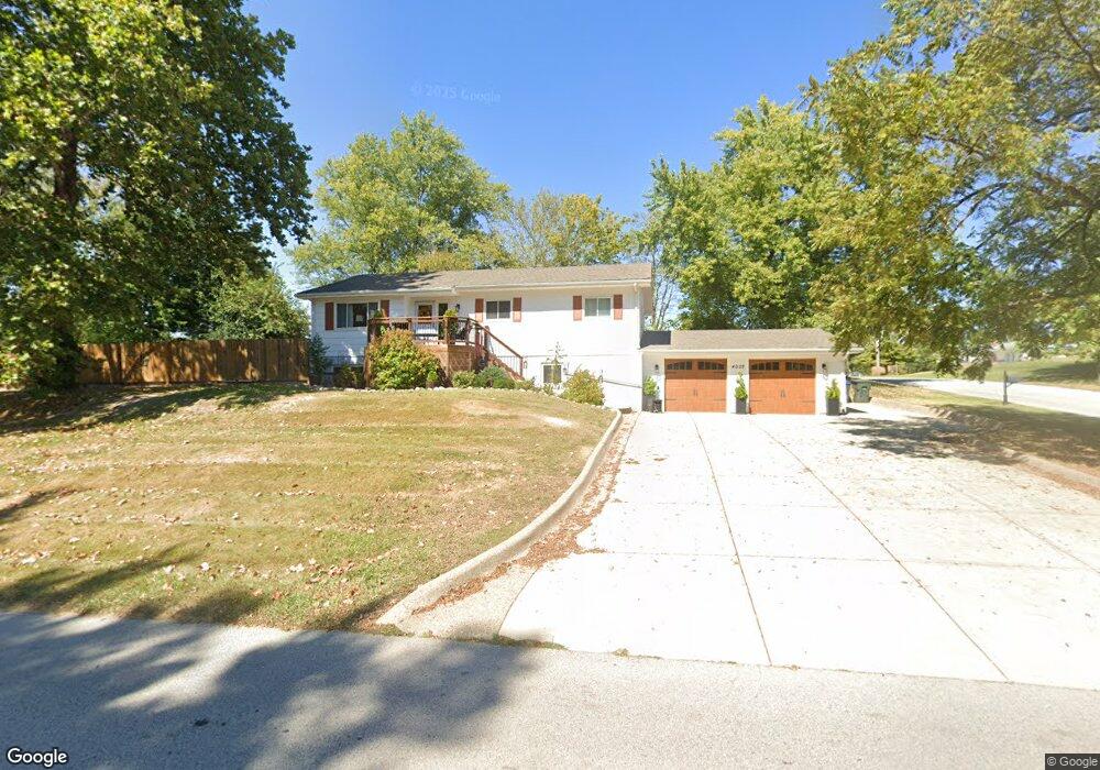
4002 West Dr Saint Peters, MO 63376
Estimated Value: $254,000 - $327,000
3
Beds
2
Baths
1,314
Sq Ft
$226/Sq Ft
Est. Value
About This Home
This home is located at 4002 West Dr, Saint Peters, MO 63376 and is currently estimated at $297,281, approximately $226 per square foot. 4002 West Dr is a home located in St. Charles County with nearby schools including Harris Elementary School, Jefferson Intermediate School, and Hardin Middle School.
Ownership History
Date
Name
Owned For
Owner Type
Purchase Details
Closed on
Jun 9, 2017
Sold by
Lent Sharon Ann and Dale And Patricia Gilman Trust
Bought by
Matteson Damion and Matteson Nicole
Current Estimated Value
Home Financials for this Owner
Home Financials are based on the most recent Mortgage that was taken out on this home.
Original Mortgage
$123,500
Outstanding Balance
$102,754
Interest Rate
4.03%
Mortgage Type
New Conventional
Estimated Equity
$194,527
Purchase Details
Closed on
Feb 26, 2001
Sold by
Gilman Billy D and Gilman Patricia A
Bought by
Gilman B Dale and Gilman Patricia Ann
Create a Home Valuation Report for This Property
The Home Valuation Report is an in-depth analysis detailing your home's value as well as a comparison with similar homes in the area
Home Values in the Area
Average Home Value in this Area
Purchase History
| Date | Buyer | Sale Price | Title Company |
|---|---|---|---|
| Matteson Damion | -- | None Available | |
| Gilman B Dale | -- | -- |
Source: Public Records
Mortgage History
| Date | Status | Borrower | Loan Amount |
|---|---|---|---|
| Open | Matteson Damion | $123,500 |
Source: Public Records
Tax History
| Year | Tax Paid | Tax Assessment Tax Assessment Total Assessment is a certain percentage of the fair market value that is determined by local assessors to be the total taxable value of land and additions on the property. | Land | Improvement |
|---|---|---|---|---|
| 2025 | $3,269 | $53,286 | -- | -- |
| 2023 | $3,262 | $43,697 | $0 | $0 |
| 2022 | $3,175 | $39,787 | $0 | $0 |
| 2021 | $3,170 | $39,787 | $0 | $0 |
| 2020 | $2,745 | $33,563 | $0 | $0 |
| 2019 | $2,726 | $33,563 | $0 | $0 |
| 2018 | $2,524 | $29,844 | $0 | $0 |
| 2017 | $2,513 | $29,844 | $0 | $0 |
| 2016 | $2,246 | $26,634 | $0 | $0 |
| 2015 | $2,242 | $26,634 | $0 | $0 |
| 2014 | $1,999 | $23,392 | $0 | $0 |
Source: Public Records
Map
Nearby Homes
- 4011 Kathleen Place
- 148 Brighton Park Dr
- 1504 Ticonderoga Dr
- 1824 Elm Tree St
- 182 S Brighton Park Ct
- 1359 Ticonderoga Dr
- 100 Gailwood Dr
- 758 Delray Dr Unit H
- 796 Delray Dr Unit J
- 2071 Hackmann Estates Dr
- 3009 Quail Run Ln
- 115 Timberidge Dr
- 88 Spencer Trail
- 2 Wells Fargo Ct
- 13 Greenfield Dr
- 7 Morning Mist Ct
- 2060 Lost Meadow Dr
- 26 Vanguard Dr
- 12 Voyager Dr
- 817 Greenridge Ln
- 0 Peach St Unit 90044413
- 0 Peach St Unit 10055467
- 1703 Cap Au Gris Dr
- 1801 Peach St
- 4006 West Dr
- 1704 Cap Au Gris Dr
- 4000 Kathleen Place
- 4004 Kathleen Place
- 1702 Cap Au Gris Dr
- 1802 Peach St
- 4004 Ridge Dr
- 4008 West Dr
- 4002 Ridge Dr
- 4006 Kathleen Place
- 3910 West Dr
- 3910 Kathleen Place
- 4006 Ridge Dr
- 3909 West Dr
- 4010 Kathleen Place
- 4010 West Dr
Your Personal Tour Guide
Ask me questions while you tour the home.