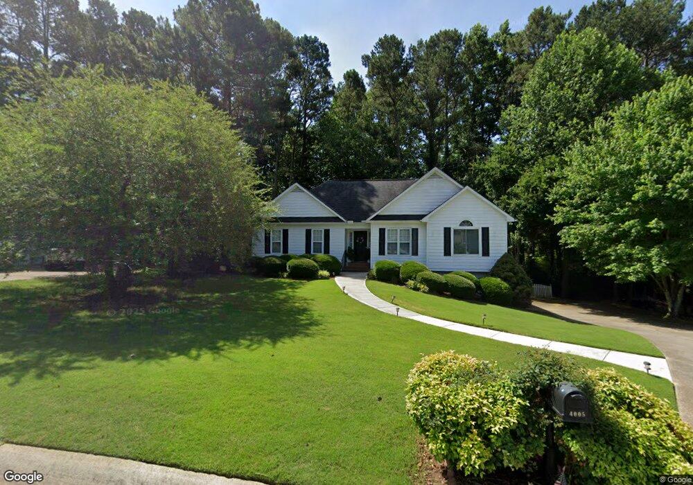
4005 Pheasant Run Trace Cumming, GA 30028
Estimated Value: $408,000 - $432,000
4
Beds
3
Baths
1,598
Sq Ft
$264/Sq Ft
Est. Value
About This Home
This home is located at 4005 Pheasant Run Trace, Cumming, GA 30028 and is currently estimated at $421,776, approximately $263 per square foot. 4005 Pheasant Run Trace is a home located in Forsyth County with nearby schools including Poole's Mill Elementary School, Liberty Middle School, and North Forsyth High School.
Ownership History
Date
Name
Owned For
Owner Type
Purchase Details
Closed on
Mar 7, 2022
Sold by
Betty Brow
Bought by
Betty Rose Brown Revocable Trust
Current Estimated Value
Purchase Details
Closed on
Sep 8, 2021
Sold by
Brown Betty Rose
Bought by
Brown Betty
Purchase Details
Closed on
May 17, 1996
Sold by
Rajala Homes Inc
Bought by
Brown Daniel Betty
Create a Home Valuation Report for This Property
The Home Valuation Report is an in-depth analysis detailing your home's value as well as a comparison with similar homes in the area
Home Values in the Area
Average Home Value in this Area
Purchase History
| Date | Buyer | Sale Price | Title Company |
|---|---|---|---|
| Betty Rose Brown Revocable Trust | -- | None Listed On Document | |
| Brown Betty | -- | None Listed On Document | |
| Brown Betty | -- | None Listed On Document | |
| Brown Betty Rose | -- | -- | |
| Brown Daniel Betty | $126,900 | -- |
Source: Public Records
Mortgage History
| Date | Status | Borrower | Loan Amount |
|---|---|---|---|
| Closed | Brown Daniel Betty | $0 |
Source: Public Records
Tax History Compared to Growth
Tax History
| Year | Tax Paid | Tax Assessment Tax Assessment Total Assessment is a certain percentage of the fair market value that is determined by local assessors to be the total taxable value of land and additions on the property. | Land | Improvement |
|---|---|---|---|---|
| 2025 | $408 | $178,516 | $48,000 | $130,516 |
| 2024 | $408 | $165,756 | $46,000 | $119,756 |
| 2023 | $310 | $151,504 | $38,000 | $113,504 |
| 2022 | $407 | $98,032 | $18,000 | $80,032 |
| 2021 | $386 | $98,032 | $18,000 | $80,032 |
| 2020 | $382 | $94,532 | $18,000 | $76,532 |
| 2019 | $385 | $93,076 | $18,000 | $75,076 |
| 2018 | $378 | $74,616 | $14,000 | $60,616 |
| 2017 | $382 | $72,084 | $14,000 | $58,084 |
| 2016 | $382 | $72,084 | $14,000 | $58,084 |
| 2015 | $374 | $66,644 | $14,000 | $52,644 |
| 2014 | $339 | $59,788 | $14,000 | $45,788 |
Source: Public Records
Map
Nearby Homes
- 3880 Deer Run Dr
- 3875 Deer Run Dr
- 3975 Silverthorn Trace
- 3945 Silverthorn Trace
- 3705 Williams Point Dr
- 3820 Pheasant Run Trace
- 3985 Haven Way
- 3975 Haven Way
- 4275 Hunters Walk Way
- 4020 Haven Way
- 4305 Hunters Walk Way
- BELLVIEW Plan at Haven Abbey
- WESTERLY Plan at Haven Abbey
- LYNNBROOK Plan at Haven Abbey
- 3905 Hurt Bridge Rd
- GRAYSON Plan at Haven Abbey
- 3435 Summerdale Walk
- 4150 Starr Creek Rd
- 4015 Pheasant Run Trace
- 3995 Pheasant Run Trace
- 3985 Pheasant Run Trace
- 4025 Pheasant Run Trace
- 4005 Seminole Trail
- 3940 Deer Run Dr Unit 145
- 3940 Deer Run Dr
- 3930 Deer Run Dr
- 3930 Deer Run Dr Unit 146
- 3950 Deer Run Dr Unit 144
- 3950 Deer Run Dr
- 3920 Deer Run Dr
- 3920 Deer Run Dr Unit 147
- 3990 Pheasant Run Trace
- 3910 Deer Run Dr Unit 3
- 3910 Deer Run Dr
- 3910 Deer Run Dr Unit 148
- 3960 Deer Run Dr Unit 143
- 3960 Deer Run Dr Unit 140
- 3960 Deer Run Dr