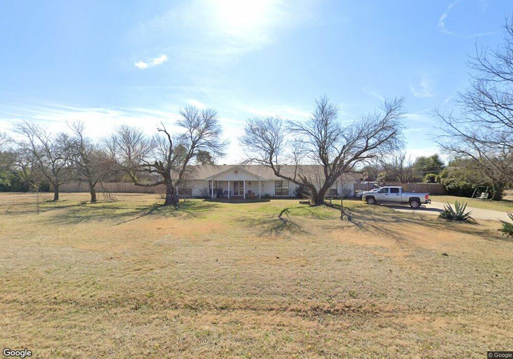
4007 Hampton Rd Denton, TX 76207
Estimated Value: $371,103 - $537,000
3
Beds
2
Baths
2,053
Sq Ft
$218/Sq Ft
Est. Value
About This Home
This home is located at 4007 Hampton Rd, Denton, TX 76207 and is currently estimated at $448,026, approximately $218 per square foot. 4007 Hampton Rd is a home located in Denton County with nearby schools including Evers Park Elementary School, Calhoun Middle School, and Denton High School.
Ownership History
Date
Name
Owned For
Owner Type
Purchase Details
Closed on
Oct 31, 2017
Sold by
Baker Austin G and Baker Russell
Bought by
Phillips Tina R and Ochoa Juan Jose
Current Estimated Value
Home Financials for this Owner
Home Financials are based on the most recent Mortgage that was taken out on this home.
Original Mortgage
$215,000
Outstanding Balance
$167,621
Interest Rate
3.78%
Mortgage Type
Purchase Money Mortgage
Estimated Equity
$280,405
Purchase Details
Closed on
Feb 16, 1994
Sold by
Eagle Farms Inc
Bought by
Baker Thomas
Create a Home Valuation Report for This Property
The Home Valuation Report is an in-depth analysis detailing your home's value as well as a comparison with similar homes in the area
Purchase History
| Date | Buyer | Sale Price | Title Company |
|---|---|---|---|
| Phillips Tina R | -- | Title Resources | |
| Baker Thomas | -- | -- |
Source: Public Records
Mortgage History
| Date | Status | Borrower | Loan Amount |
|---|---|---|---|
| Open | Phillips Tina R | $215,000 |
Source: Public Records
Tax History
| Year | Tax Paid | Tax Assessment Tax Assessment Total Assessment is a certain percentage of the fair market value that is determined by local assessors to be the total taxable value of land and additions on the property. | Land | Improvement |
|---|---|---|---|---|
| 2025 | $2,749 | $223,860 | $151,890 | $92,385 |
| 2024 | $3,944 | $204,351 | $0 | $0 |
| 2023 | $2,335 | $184,965 | $148,975 | $131,479 |
| 2022 | $4,603 | $216,832 | $91,960 | $124,872 |
| 2021 | $3,407 | $153,236 | $60,800 | $92,436 |
| 2020 | $3,670 | $160,579 | $60,800 | $99,779 |
| 2019 | $3,877 | $162,493 | $60,800 | $101,693 |
| 2018 | $3,983 | $164,884 | $60,800 | $104,084 |
| 2017 | $3,955 | $160,000 | $60,800 | $99,200 |
| 2016 | $4,163 | $168,420 | $60,800 | $107,620 |
| 2015 | $3,874 | $162,986 | $54,053 | $108,933 |
| 2013 | -- | $123,027 | $45,945 | $77,082 |
Source: Public Records
Map
Nearby Homes
- 2112 Windsor Farms Dr
- 2909 Savill Garden
- 2712 Claydon Dr
- 2905 Lakewood Dr
- 2904 Lakewood Dr
- 2717 Wendell Dr
- 9909 Morning Cloak Dr
- 2620 John Dr
- 8540 W University Dr
- 2316 Overlook Ln
- 2225 Southway
- 2324 Southway
- 1627 Kawati Way
- 5276 Albert Ct
- 3400 Kingsview Dr
- 5258 Albert Ct
- 334 Saddlebrook Dr
- 3616 Kingsgarden Rd
- 328 Saddlebrook Dr
- 492 Thomas j Egan Rd
- 4001 Hampton Rd
- 4109 Hampton Rd
- 2019 N Lariat Rd
- 3919 Hampton Rd
- 2013 N Lariat Rd
- 2018 N Lariat Rd
- 3913 Hampton Rd
- 2007 N Lariat Rd
- 4115 Hampton Rd
- 3907 Hampton Rd
- 2000 N Lariat Rd
- 1919 N Lariat Rd
- 1918 N Lariat Rd
- 3901 Hampton Rd
- 2013 Cindy Ln
- 1913 N Lariat Rd
- 2001 Cindy Ln
- 1912 N Lariat Rd
- 3819 Hampton Rd
- 4636 Hampton Rd
Your Personal Tour Guide
Ask me questions while you tour the home.