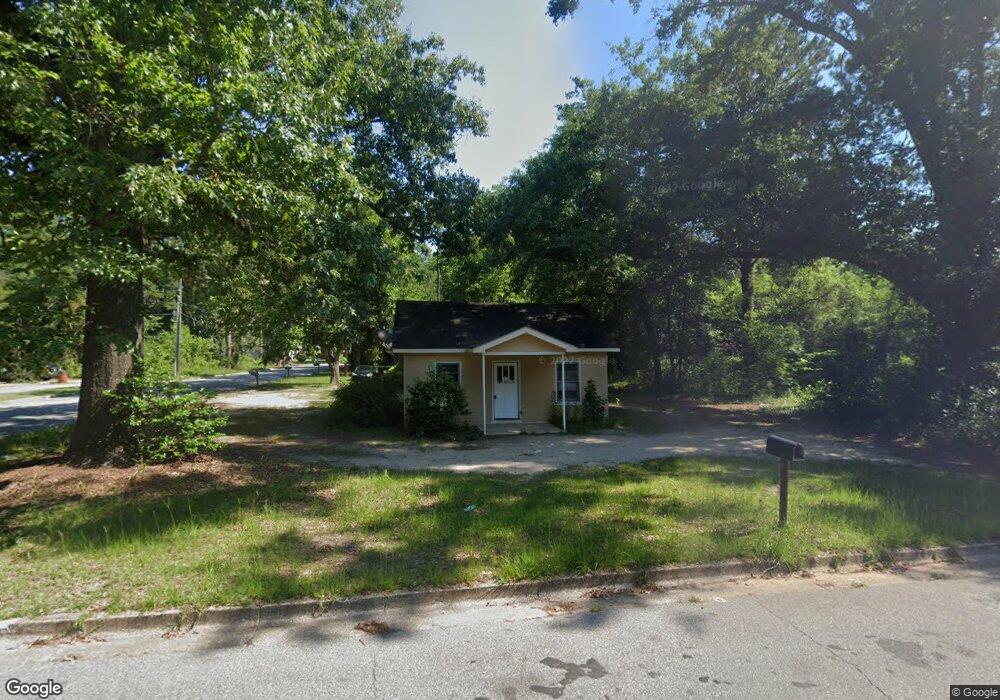
401 Bobbitt Dr Albany, GA 31705
Dixie Heights NeighborhoodEstimated Value: $50,187 - $77,000
2
Beds
1
Bath
624
Sq Ft
$97/Sq Ft
Est. Value
About This Home
This home is located at 401 Bobbitt Dr, Albany, GA 31705 and is currently estimated at $60,797, approximately $97 per square foot. 401 Bobbitt Dr is a home located in Dougherty County with nearby schools including Morningside Elementary School, Southside Middle School, and Monroe High School.
Ownership History
Date
Name
Owned For
Owner Type
Purchase Details
Closed on
Mar 9, 2015
Sold by
Mitchell Larry
Bought by
Honibee Properties Management
Current Estimated Value
Purchase Details
Closed on
Mar 29, 2000
Sold by
Hall Michael C and Wiley Hardwick
Bought by
Mitchell Larry Ed and Joyce Mitchell
Purchase Details
Closed on
Dec 31, 1997
Sold by
Skaggs Jonathan L Aka John
Bought by
Hardwick Wiley
Purchase Details
Closed on
Dec 22, 1993
Sold by
Rucker Est Carl& H W
Bought by
Skaggs Skaggs and Skaggs Hall
Purchase Details
Closed on
Dec 21, 1993
Sold by
Duke Lois
Bought by
Skaggs Skaggs and Skaggs Hall
Purchase Details
Closed on
May 6, 1982
Sold by
Rucker Carl
Bought by
Rucker Frances
Create a Home Valuation Report for This Property
The Home Valuation Report is an in-depth analysis detailing your home's value as well as a comparison with similar homes in the area
Home Values in the Area
Average Home Value in this Area
Purchase History
| Date | Buyer | Sale Price | Title Company |
|---|---|---|---|
| Honibee Properties Management | -- | -- | |
| Mitchell Larry Ed | $27,000 | -- | |
| Hardwick Wiley | $215,000 | -- | |
| Skaggs Skaggs | $12,400 | -- | |
| Skaggs Skaggs | -- | -- | |
| Rucker Frances | -- | -- |
Source: Public Records
Tax History Compared to Growth
Tax History
| Year | Tax Paid | Tax Assessment Tax Assessment Total Assessment is a certain percentage of the fair market value that is determined by local assessors to be the total taxable value of land and additions on the property. | Land | Improvement |
|---|---|---|---|---|
| 2024 | $685 | $14,360 | $2,160 | $12,200 |
| 2023 | $669 | $14,360 | $2,160 | $12,200 |
| 2022 | $672 | $14,360 | $2,160 | $12,200 |
| 2021 | $623 | $14,360 | $2,160 | $12,200 |
| 2020 | $624 | $14,360 | $2,160 | $12,200 |
| 2019 | $626 | $14,360 | $2,160 | $12,200 |
| 2018 | $629 | $14,360 | $2,160 | $12,200 |
| 2017 | $586 | $14,360 | $2,160 | $12,200 |
| 2016 | $586 | $14,360 | $2,160 | $12,200 |
| 2015 | $588 | $14,360 | $2,160 | $12,200 |
| 2014 | $556 | $13,760 | $1,560 | $12,200 |
Source: Public Records
Map
Nearby Homes
- 939 Crawford Dr
- 1013 Crawford Dr
- 916 Crawford Dr
- 502 Mitchell Ave
- 911 Mercedes St
- 925 Mercedes St
- 1102 Van Deman St
- 1304 Mobile Ave
- 111 Morningside Dr
- 113 Morningside Dr
- 403 Farkas Ln
- 1401 E Waddell Ave
- 211 Cannon Ave
- 1400 E Lincoln Ave
- 811 S Maple St
- 1411 E Gordon Ave
- 1408 E Mercer Ave
- 608 Cason St
- 211 Collins St
- 205 Collins St