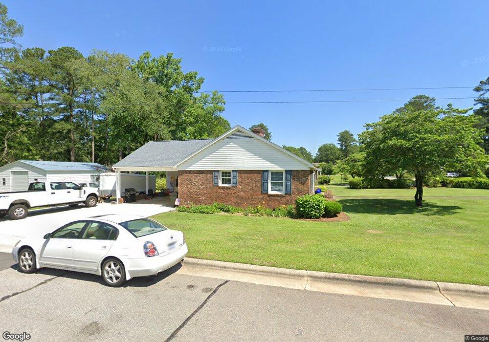
401 Curtis Dr Rockingham, NC 28379
Estimated Value: $236,000 - $340,000
Studio
--
Bath
1,756
Sq Ft
$157/Sq Ft
Est. Value
About This Home
This home is located at 401 Curtis Dr, Rockingham, NC 28379 and is currently estimated at $275,772, approximately $157 per square foot. 401 Curtis Dr is a home with nearby schools including L.J. Bell Elementary School, Rockingham Middle School, and Richmond Senior High School.
Ownership History
Date
Name
Owned For
Owner Type
Purchase Details
Closed on
Feb 24, 2022
Sold by
Campbell Iii George W and Barnes Martha
Bought by
Campbell George W and Campbell Martha Barnes
Current Estimated Value
Home Financials for this Owner
Home Financials are based on the most recent Mortgage that was taken out on this home.
Original Mortgage
$115,000
Outstanding Balance
$100,471
Interest Rate
3.69%
Mortgage Type
New Conventional
Estimated Equity
$175,301
Purchase Details
Closed on
Aug 27, 2004
Bought by
Campbell George W
Create a Home Valuation Report for This Property
The Home Valuation Report is an in-depth analysis detailing your home's value as well as a comparison with similar homes in the area
Purchase History
| Date | Buyer | Sale Price | Title Company |
|---|---|---|---|
| Campbell George W | -- | Chicago Title | |
| Campbell George W | -- | Chicago Title | |
| Campbell George W | $114,500 | -- |
Source: Public Records
Mortgage History
| Date | Status | Borrower | Loan Amount |
|---|---|---|---|
| Open | Campbell George W | $115,000 | |
| Closed | Campbell George W | $115,000 |
Source: Public Records
Tax History
| Year | Tax Paid | Tax Assessment Tax Assessment Total Assessment is a certain percentage of the fair market value that is determined by local assessors to be the total taxable value of land and additions on the property. | Land | Improvement |
|---|---|---|---|---|
| 2025 | $1,971 | $251,738 | $25,990 | $225,748 |
| 2024 | $2,022 | $251,738 | $25,990 | $225,748 |
| 2023 | $1,345 | $146,425 | $20,792 | $125,633 |
| 2022 | $1,345 | $146,425 | $20,792 | $125,633 |
| 2021 | $1,341 | $146,425 | $20,792 | $125,633 |
| 2020 | $1,337 | $146,425 | $20,792 | $125,633 |
| 2019 | $1,185 | $128,185 | $20,792 | $107,393 |
| 2018 | $1,185 | $128,185 | $20,792 | $107,393 |
| 2016 | $1,095 | $128,185 | $20,792 | $107,393 |
| 2014 | -- | $128,869 | $19,533 | $109,336 |
Source: Public Records
Map
Nearby Homes
- 417 Louise Ave
- 432 Lumyer Rd
- 1914 Crescent Dr
- 1907 Anthony Ave
- 321 Richmond Rd
- 1431 Cumberland Cir
- 609 Deweese Ave
- 710 Scotland Ave
- 1811 Sunset Belt
- 1707 Pine St
- 1615 Plum Nelly Rd
- TBD Hwy74 Bypass Hwy 74 Interchange
- 1206 Lancaster Ln
- 714 Richmond Rd
- 110 N Grove Ave
- 828 Chatham Rd
- 1113 Fayetteville Rd
- 106 Starlight Dr
- 1019 Fayetteville Rd
- 911 Ann St
Your Personal Tour Guide
Ask me questions while you tour the home.