
Seller's Agent in 2025
Dan Gutfreund
Signature Sotheby's International Realty Bham
(248) 497-4646
13 in this area
250 Total Sales
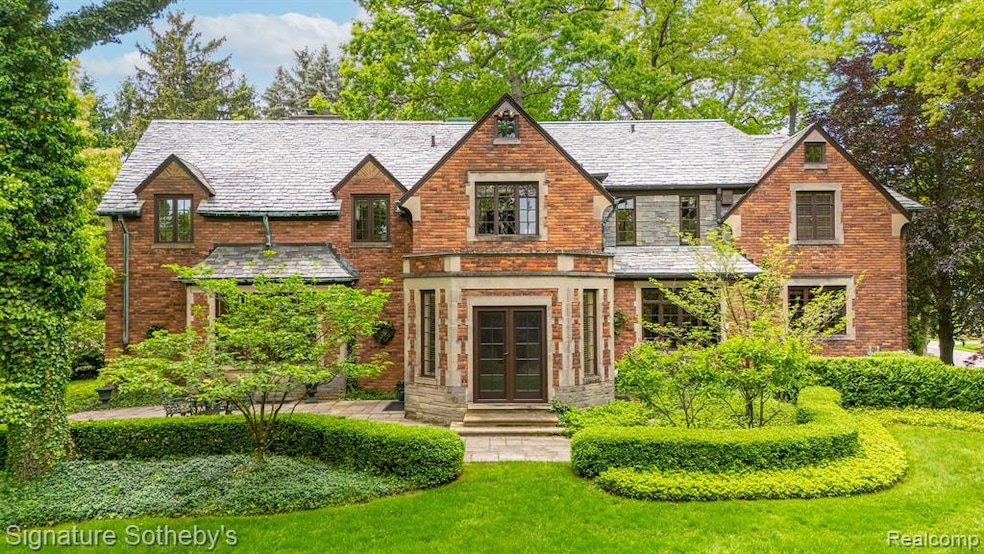
Tucked beneath a canopy of mature oak trees in the heart of Bloomfield Hills Proper, 401 Dunston Rd is a distinguished estate set on 2.1 private acres—offering timeless architecture and enduring presence just minutes from Cranbrook. This meticulously maintained 5-bed, 5.2-bath home offers nearly 5,000 sq ft plus a fully finished daylight lower level. A slate roof, hand-carved limestone entry, and leaded glass windows establish a stately tone on arrival. Inside, arched thresholds, detailed plasterwork, and hardwood flooring reveal craftsmanship rarely seen today. The formal living room is filled with natural light and anchored by a traditional fireplace, while the paneled library offers an intimate setting with custom millwork, built-in shelving, and a limestone hearth. The kitchen has been completely reimagined with custom cabinetry, intricate wood detailing, granite countertops, and high-end appliances. A restored icebox adds charm, while the sunlit breakfast nook offers panoramic garden views. The adjacent sunroom and richly styled formal dining room further elevate the main level. All five bedrooms are upstairs, each with its own private bathroom. The primary suite is tucked away with its own entry, vanity area, and spacious bath. The bathrooms have all been updated to reflect the home’s classic aesthetic while enhancing function. The finished daylight lower level includes a large living area, flexible rec space, and ample storage. A partial house generator adds peace of mind.
Outside, manicured hedges frame winding brick paths and stone patios, while mature trees and flowering shrubs offer year-round beauty and privacy. This rare offering blends architectural integrity, meaningful updates, and quiet sophistication on one of Bloomfield Hills’ most prestigious streets. Back on the market after the prior buyer withdrew for personal reasons—not due to condition. The home inspected exceptionally well with no issues.
Last Agent to Sell the Property
Signature Sotheby's International Realty Bham License #6501367800 Listed on: 06/16/2025
| Date | Type | Sale Price | Title Company |
|---|---|---|---|
| Warranty Deed | $3,700,000 | Title One | |
| Deed | -- | -- | |
| Warranty Deed | -- | -- |
| Date | Status | Loan Amount | Loan Type |
|---|---|---|---|
| Previous Owner | $1,240,000 | No Value Available |
| Date | Event | Price | List to Sale | Price per Sq Ft |
|---|---|---|---|---|
| 07/30/2025 07/30/25 | Sold | $3,700,000 | -2.6% | $740 / Sq Ft |
| 07/03/2025 07/03/25 | Pending | -- | -- | -- |
| 06/16/2025 06/16/25 | For Sale | $3,799,000 | -- | $760 / Sq Ft |
| Year | Tax Paid | Tax Assessment Tax Assessment Total Assessment is a certain percentage of the fair market value that is determined by local assessors to be the total taxable value of land and additions on the property. | Land | Improvement |
|---|---|---|---|---|
| 2024 | $26,886 | $1,159,510 | $0 | $0 |
| 2023 | $21,307 | $1,070,000 | $0 | $0 |
| 2022 | $23,010 | $1,061,380 | $0 | $0 |
| 2021 | $22,529 | $1,030,480 | $0 | $0 |
| 2020 | $20,101 | $977,450 | $0 | $0 |
| 2019 | $22,348 | $970,770 | $0 | $0 |
| 2018 | $22,123 | $941,970 | $0 | $0 |
| 2017 | $21,846 | $866,060 | $0 | $0 |
| 2016 | $21,863 | $810,670 | $0 | $0 |
| 2015 | -- | $759,510 | $0 | $0 |
| 2014 | -- | $611,270 | $0 | $0 |
| 2011 | -- | $579,800 | $0 | $0 |
Seller's Agent in 2025
Dan Gutfreund
Signature Sotheby's International Realty Bham
(248) 497-4646
13 in this area
250 Total Sales
E
Buyer's Agent in 2025
Erin O'neill
The Agency Hall & Hunter
(248) 644-6300
1 in this area
22 Total Sales
Source: Realcomp
MLS Number: 20251008684
APN: 19-23-352-018
Disclaimer: Certain information contained herein is derived from information provided by parties other than Homes.com. All information provided is deemed reliable, but is not guaranteed to be accurate and should be independently verified.
![]() IDX provided courtesy of Realcomp II Ltd. via Ten-X and MLS
IDX provided courtesy of Realcomp II Ltd. via Ten-X and MLS
Copyright 2025 Realcomp II Ltd. Shareholders
IDX information is provided exclusively for consumers' personal, noncommercial use and may not be used for any purpose other than to identify prospective properties consumers may be interested in purchasing. The accuracy of all information, regardless of source, is not guaranteed or warranted. All information should be independently verified.
Listing Information presented by local MLS brokerage: Ten-X, local REALTOR®- Arlene Richardson - (888)-952-6393