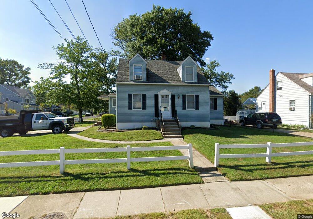
401 E Mill Rd Maple Shade, NJ 08052
Estimated Value: $318,765 - $384,000
Studio
--
Bath
1,755
Sq Ft
$197/Sq Ft
Est. Value
About This Home
This home is located at 401 E Mill Rd, Maple Shade, NJ 08052 and is currently estimated at $345,441, approximately $196 per square foot. 401 E Mill Rd is a home located in Burlington County with nearby schools including Maude M. Wilkins Elementary School, Ralph J Steinhauer Elementary School, and Howard R Yocum School.
Ownership History
Date
Name
Owned For
Owner Type
Purchase Details
Closed on
Sep 28, 2021
Sold by
Rathgeb C Doris C and Rathgeb Barbara
Bought by
Schoonover Jeffrey A
Current Estimated Value
Home Financials for this Owner
Home Financials are based on the most recent Mortgage that was taken out on this home.
Original Mortgage
$215,000
Outstanding Balance
$196,060
Interest Rate
2.8%
Mortgage Type
VA
Estimated Equity
$149,381
Create a Home Valuation Report for This Property
The Home Valuation Report is an in-depth analysis detailing your home's value as well as a comparison with similar homes in the area
Home Values in the Area
Average Home Value in this Area
Purchase History
| Date | Buyer | Sale Price | Title Company |
|---|---|---|---|
| Schoonover Jeffrey A | $215,000 | Presidential Title Agcy Inc |
Source: Public Records
Mortgage History
| Date | Status | Borrower | Loan Amount |
|---|---|---|---|
| Open | Schoonover Jeffrey A | $215,000 |
Source: Public Records
Tax History
| Year | Tax Paid | Tax Assessment Tax Assessment Total Assessment is a certain percentage of the fair market value that is determined by local assessors to be the total taxable value of land and additions on the property. | Land | Improvement |
|---|---|---|---|---|
| 2025 | $7,026 | $185,100 | $46,500 | $138,600 |
| 2024 | $6,823 | $185,100 | $46,500 | $138,600 |
| 2023 | $6,823 | $185,100 | $46,500 | $138,600 |
| 2022 | $6,692 | $184,400 | $45,800 | $138,600 |
| 2021 | $6,127 | $184,400 | $45,800 | $138,600 |
| 2020 | $6,646 | $184,400 | $45,800 | $138,600 |
| 2019 | $6,402 | $184,400 | $45,800 | $138,600 |
| 2018 | $6,292 | $184,400 | $45,800 | $138,600 |
| 2017 | $5,718 | $184,400 | $45,800 | $138,600 |
| 2016 | $5,626 | $184,400 | $45,800 | $138,600 |
| 2015 | $5,493 | $184,400 | $45,800 | $138,600 |
| 2014 | $5,310 | $184,400 | $45,800 | $138,600 |
Source: Public Records
Map
Nearby Homes
- 452 Elm Ave
- 115 S Walnut Ave
- 206 S Maple Ave
- 44 S Pine Ave
- 42 Spruce Ave
- 15 S Pine Ave
- 61 S Maple Ave
- 66 W Center Ave
- 47 S Lippincott Ave
- 26 Morris Ave
- 22 Theodore Ave
- 57 S Terrace Ave
- 115 E Kings Hwy Unit 187
- 115 E Kings Hwy Unit 125
- 207 E Park Ave
- 411 A3 Stiles Ave Unit A-3
- 411 C12 Stiles Ave Unit C-12
- 411 A2 Stiles Ave Unit A-2
- 169 Cherry Tree Ln
- 3005 Garfield Ave
Your Personal Tour Guide
Ask me questions while you tour the home.