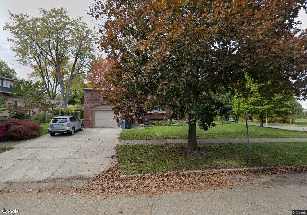
401 Moores River Dr Lansing, MI 48910
Moores Park NeighborhoodEstimated Value: $167,000 - $184,000
Studio
2
Baths
1,662
Sq Ft
$105/Sq Ft
Est. Value
About This Home
This home is located at 401 Moores River Dr, Lansing, MI 48910 and is currently estimated at $174,356, approximately $104 per square foot. 401 Moores River Dr is a home located in Ingham County with nearby schools including Averill Elementary School, Pattengill Academy, and J.W. Sexton High School.
Ownership History
Date
Name
Owned For
Owner Type
Purchase Details
Closed on
Feb 16, 2021
Sold by
Gualtieri Paul F and Marshall Michael G
Bought by
Gualtieri Paul F and Marshall Michael G
Current Estimated Value
Purchase Details
Closed on
May 18, 2006
Sold by
Gualtieri Paul F
Bought by
Gualtieri Paul F and Marshall Michael G
Purchase Details
Closed on
Mar 20, 2002
Sold by
Gualtieri Paul F
Bought by
Gualtieri Paul F and Marshall Michael G
Purchase Details
Closed on
May 1, 1995
Create a Home Valuation Report for This Property
The Home Valuation Report is an in-depth analysis detailing your home's value as well as a comparison with similar homes in the area
Home Values in the Area
Average Home Value in this Area
Purchase History
| Date | Buyer | Sale Price | Title Company |
|---|---|---|---|
| Gualtieri Paul F | -- | None Available | |
| Gualtieri Paul F | -- | None Available | |
| Gualtieri Paul F | -- | First American Title Ins Co | |
| -- | $76,000 | -- |
Source: Public Records
Tax History
| Year | Tax Paid | Tax Assessment Tax Assessment Total Assessment is a certain percentage of the fair market value that is determined by local assessors to be the total taxable value of land and additions on the property. | Land | Improvement |
|---|---|---|---|---|
| 2025 | $3,975 | $80,300 | $6,800 | $73,500 |
| 2024 | $32 | $82,400 | $6,800 | $75,600 |
| 2023 | $3,725 | $71,700 | $6,800 | $64,900 |
| 2022 | $3,355 | $66,800 | $9,700 | $57,100 |
| 2021 | $3,285 | $61,000 | $7,200 | $53,800 |
| 2020 | $3,266 | $58,900 | $7,200 | $51,700 |
| 2019 | $3,132 | $53,600 | $7,200 | $46,400 |
| 2018 | $2,933 | $52,100 | $7,200 | $44,900 |
| 2017 | $2,809 | $52,100 | $7,200 | $44,900 |
| 2016 | $2,679 | $51,100 | $7,200 | $43,900 |
| 2015 | $2,679 | $48,500 | $14,476 | $34,024 |
| 2014 | $2,679 | $48,000 | $8,444 | $39,556 |
Source: Public Records
Map
Nearby Homes
- 310 W Barnes Ave
- 227 Woodlawn Ave
- 205 Moores River Dr
- 139 Woodlawn Ave
- 202 Woodlawn Ave
- 1408 Reo Ave
- 1723 Osband Ave
- 1824 Davis Ave
- 1406 Reo Ave
- 147 Isbell St
- 612 W Mount Hope Ave
- 717 Smith Ave
- 1807 Teel Ave
- 1917 Teel Ave
- 712 Lenore Ave
- 1400 Pico Ave
- 315 E Mount Hope Ave
- 1017 W Barnes Ave
- 1839 Fletcher St
- 218 E Elm St
- 407 Moores River Dr
- 1610 Davis Ave
- 411 Moores River Dr
- 419 Moores River Dr
- Moores River Dr
- 1616 Davis Ave
- 327 Moores River Dr
- 1620 Davis Ave
- 323 Moores River Dr
- 1609 Davis Ave
- 1617 Davis Ave
- 414 W Barnes Ave
- 400 W Barnes Ave
- 319 Moores River Dr
- 416 W Barnes Ave
- 1621 Davis Ave
- 427 Moores River Dr
- 1611 Bradley Ave
- 1617 Bradley Ave
- 315 Moores River Dr