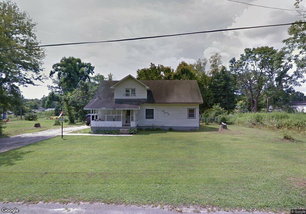
401 Oxford St Vineland, NJ 08360
Estimated Value: $260,000 - $369,000
--
Bed
--
Bath
1,794
Sq Ft
$169/Sq Ft
Est. Value
About This Home
This home is located at 401 Oxford St, Vineland, NJ 08360 and is currently estimated at $303,139, approximately $168 per square foot. 401 Oxford St is a home located in Cumberland County with nearby schools including Max Leuchter Elementary School, T.W. Wallace Middle School, and Vineland Senior High School.
Ownership History
Date
Name
Owned For
Owner Type
Purchase Details
Closed on
Aug 29, 1997
Sold by
Ritondaro Dominick
Bought by
Holmes Gregory T
Current Estimated Value
Home Financials for this Owner
Home Financials are based on the most recent Mortgage that was taken out on this home.
Original Mortgage
$82,000
Outstanding Balance
$12,585
Interest Rate
7.36%
Mortgage Type
FHA
Estimated Equity
$290,554
Create a Home Valuation Report for This Property
The Home Valuation Report is an in-depth analysis detailing your home's value as well as a comparison with similar homes in the area
Home Values in the Area
Average Home Value in this Area
Purchase History
| Date | Buyer | Sale Price | Title Company |
|---|---|---|---|
| Holmes Gregory T | $82,000 | -- |
Source: Public Records
Mortgage History
| Date | Status | Borrower | Loan Amount |
|---|---|---|---|
| Open | Holmes Gregory T | $82,000 |
Source: Public Records
Tax History Compared to Growth
Tax History
| Year | Tax Paid | Tax Assessment Tax Assessment Total Assessment is a certain percentage of the fair market value that is determined by local assessors to be the total taxable value of land and additions on the property. | Land | Improvement |
|---|---|---|---|---|
| 2025 | $5,082 | $159,600 | $33,200 | $126,400 |
| 2024 | $5,082 | $159,600 | $33,200 | $126,400 |
| 2023 | $5,048 | $159,600 | $33,200 | $126,400 |
| 2022 | $4,898 | $159,600 | $33,200 | $126,400 |
| 2021 | $4,426 | $146,900 | $33,200 | $113,700 |
| 2020 | $4,300 | $146,900 | $33,200 | $113,700 |
| 2019 | $4,241 | $146,900 | $33,200 | $113,700 |
| 2018 | $4,129 | $146,900 | $33,200 | $113,700 |
| 2017 | $3,922 | $146,900 | $33,200 | $113,700 |
| 2016 | $3,784 | $146,900 | $33,200 | $113,700 |
| 2015 | $3,645 | $146,900 | $33,200 | $113,700 |
| 2014 | $3,446 | $146,900 | $33,200 | $113,700 |
Source: Public Records
Map
Nearby Homes
- 550 Northwest Ave
- 108 W Park Ave
- 330 W Peach St
- 1298 W Cornell St
- 1267 Northeast Blvd
- 400 N 7th St
- 663 Wayne Ave
- 1143 N East Ave
- 636 E Pear St
- 818 E Pear St
- 411 N East Ave
- 409 N East Ave
- 1489 N Delsea Dr
- 1249 Sassafras Dr
- 785 E Oak Rd
- 48 N Myrtle St
- 711 Timber Brook Dr
- 329 W Grape St
- 511 E Grape St
- 1230 Ramblewood Dr