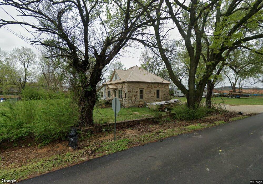
401 S Pittman St Prairie Grove, AR 72753
Estimated Value: $196,859 - $265,000
--
Bed
1
Bath
1,673
Sq Ft
$143/Sq Ft
Est. Value
About This Home
This home is located at 401 S Pittman St, Prairie Grove, AR 72753 and is currently estimated at $239,965, approximately $143 per square foot. 401 S Pittman St is a home located in Washington County with nearby schools including Prairie Grove Elementary School, Prairie Grove Middle School, and Prairie Grove Junior High School.
Ownership History
Date
Name
Owned For
Owner Type
Purchase Details
Closed on
Feb 1, 2012
Sold by
Lowery Nathan Lavon and Lowery Kasie Rhainnon
Bought by
Lowery Nathan Lavon and Lowery Cynthia Ann
Current Estimated Value
Purchase Details
Closed on
Feb 14, 1989
Bought by
Lowery Paul Guardian For Nath- and An Leavon Lowery,Paul As Guard
Purchase Details
Closed on
Jan 1, 1985
Bought by
Foren Ellnora I
Create a Home Valuation Report for This Property
The Home Valuation Report is an in-depth analysis detailing your home's value as well as a comparison with similar homes in the area
Home Values in the Area
Average Home Value in this Area
Purchase History
| Date | Buyer | Sale Price | Title Company |
|---|---|---|---|
| Lowery Nathan Lavon | -- | None Available | |
| Lowery Paul Guardian For Nath- | -- | -- | |
| Foren Ellnora I | -- | -- |
Source: Public Records
Tax History Compared to Growth
Tax History
| Year | Tax Paid | Tax Assessment Tax Assessment Total Assessment is a certain percentage of the fair market value that is determined by local assessors to be the total taxable value of land and additions on the property. | Land | Improvement |
|---|---|---|---|---|
| 2025 | $364 | $33,780 | $11,900 | $21,880 |
| 2024 | $437 | $33,780 | $11,900 | $21,880 |
| 2023 | $504 | $33,780 | $11,900 | $21,880 |
| 2022 | $509 | $19,020 | $4,900 | $14,120 |
| 2021 | $471 | $19,020 | $4,900 | $14,120 |
| 2020 | $429 | $19,020 | $4,900 | $14,120 |
| 2019 | $400 | $14,240 | $3,600 | $10,640 |
| 2018 | $425 | $14,240 | $3,600 | $10,640 |
| 2017 | $418 | $14,240 | $3,600 | $10,640 |
| 2016 | $418 | $14,240 | $3,600 | $10,640 |
| 2015 | $418 | $14,240 | $3,600 | $10,640 |
| 2014 | $468 | $15,180 | $3,600 | $11,580 |
Source: Public Records
Map
Nearby Homes
- 211 Boston St
- 308 S Summit St
- 304 S Summit St
- TBD Butler St
- 106 S Ozark St
- 107 S Ozark St
- 700 Marcella St
- 600 Kendra St
- 621 Kendra St
- 740 Kendra St
- 610 Kendra St
- 4.66 +/- AC Tract 5 Hwy 62 & S Mock St
- 901 E Buchanan St
- 881 E Buchanan St
- 720 Marcella St
- 661 Marcella St
- 611 Marcella St
- 651 Marcella St
- 630 Marcella St
- 621 Marcella St
- 404 S Pittman St
- 309 S Pittman St
- 313 Commercial St
- 408 S Pittman St
- 310 S Pittman St
- 311 Commercial St
- 311 Commercial St
- 412 S Pittman St
- 306 S Pittman St
- 306 S Pittman St Unit 1 & 2
- 312 Commercial St
- 310 Commercial St
- 305 S Pittman St
- 307 Commercial St
- 416 S Pittman St
- 321 E Thurman St
- 306 Commercial St
- 418 S Pittman St
- 301 S Pittman St
- 311 and 313 E Thurman St Unit 1-5